
University of Vermont University of Vermont
UVM ScholarWorks UVM ScholarWorks
Transportation Research Center Research
Reports
Research Centers and Institutes
9-13-2021
CCRPC Active Transportation Plan Evaluation CCRPC Active Transportation Plan Evaluation
Gregory Rowangould
UVM
, gregory[email protected]
Eliana Fox
UVM
Follow this and additional works at: https://scholarworks.uvm.edu/trc
Part of the Transportation Engineering Commons
Recommended Citation Recommended Citation
Rowangould, G. and E Fox. (September 2021). CCRPC Active Transportation Plan Evaluation. Prepared by
the University of Vermont Transportation Research Center for the Chittenden County Regional
Transportation Planning Commission, Winooski, VT.
This Report is brought to you for free and open access by the Research Centers and Institutes at UVM
ScholarWorks. It has been accepted for inclusion in Transportation Research Center Research Reports by an
authorized administrator of UVM ScholarWorks. For more information, please contact scholar[email protected].

CCRPC Active Transportation Plan Evaluation
September 13, 2021
Prepared by:
Dr. Gregory Rowangould and Eliana Fox
University of Vermont Transportation Research Center
25 Colchester Avenue, Burlington, VT 05405
www.uvm.edu/cems/trc
Prepared for:
Chittenden County Regional Planning Commission
10 West Canal Street, Suite 202
Winooski, Vermont 05404

UVM Transportation Research Center 2
CONTENTS
1 Introduction .......................................................................................................................................... 3
2 Implementation Status ......................................................................................................................... 4
2.1 Recommended Active Transportation Network ........................................................................... 4
2.2 Other Infrastructure Recommendations ...................................................................................... 8
2.2.1 Short Term/Immediate Recommendations .......................................................................... 8
2.2.2 Long-Term Recommendations ............................................................................................ 10
2.3 Engineering ................................................................................................................................. 13
2.4 Non-Infrastructure ...................................................................................................................... 17
3 Evaluating the Planning and Prioritization Process ............................................................................ 23
3.1 Proposed ATP Network ............................................................................................................... 23
3.1.1 Developing the Proposed ATP Network .............................................................................. 23
3.1.2 Prioritizing ATP Network Projects ....................................................................................... 25
3.2 Other Recommendations ............................................................................................................ 27
3.3 Performance Measures ............................................................................................................... 27
4 Recommendations .............................................................................................................................. 28
4.1 Use an Accessibility Focused Framework to Prioritize Infrastructure Projects .......................... 29
4.2 Evaluate and Prioritize Other Infrastructure, Policy and Programmatic Recommendations ..... 32
4.3 Use Consistent, Outcome Focused, Performance Measures...................................................... 34
4.4 Provide More Detailed Information to Guide Implementation of Specific Recommendations . 35
4.5 Additional Recommendations..................................................................................................... 36
5 References Cited ................................................................................................................................. 37
Appendix A – Infrastructure Project Status ................................................................................................ 39
TABLES
Table 1 Short Term Recommendations ........................................................................................................ 9
Table 2 Long Term Recommendations ....................................................................................................... 11
Table 3 Engineering Recommendations ..................................................................................................... 14
Table 4 Education Recommendations ........................................................................................................ 18
Table 5 Encouragement Recommendations ............................................................................................... 19
Table 6 Enforcement Recommendations ................................................................................................... 20
Table 7 Evaluation Recommendations ....................................................................................................... 21

UVM Transportation Research Center 3
1 INTRODUCTION
The UVM Transportation Research Center (“TRC”) evaluated the Chittenden County Regional Planning
Commission (“CCRPC”) 2017 Active Transportation Plan (“ATP”) to determine the current
implementation status of the plan’s recommendations and develop a strategy for implementing and
prioritizing the ATP’s remaining projects and recommendations.
We evaluated the implementation of each ATP recommendation through a combination of methods
including, visual inspection of roadway infrastructure through aerial imagery and field studies, a search
of records and policies on each municipality’s website, evaluation of recent Transportation
Improvement Program (TIP) projects, contacting municipal staff, conducting an electronic survey sent to
planning and/or public works staff in each municipality, and our research team’s local knowledge of the
region. Determining the implementation status of each ATP recommendation was extremely challenging
and not always possible. The ATP provides a wide range of recommendations including a proposed
active travel network (“ATP network”) along with many design, planning and policy recommendations. A
particular challenge in determining the implementation status of the proposed ATP network is the lack
of detail in what needs to be built. While the ATP identifies network links that lack sufficient bicycle
infrastructure, it does not include recommendations on what changes are required. Evaluating the
implementation status of the other ATP recommendations was even more difficult. Many
recommendations were described as “encouraging” or “assisting with” the implementation of a specific
recommendation and it was often unclear who was responsible for providing encouragement and
assistance or how encouragement and assistance should be provided. In many instances we were able
to identify municipalities that have adopted various recommendations, but we were often unable to
determine if their adoption was in response to the ATP or specific encouragement or assistance
activities.
After evaluating the implementation status of the recommendations in the plan, we considered how the
remaining ATP recommendations could be implemented and prioritized. We began by evaluating the
data and analytical methods used to generate and prioritize the current recommendations in the ATP.
Our review identified a number of limitations in the original planning and prioritization process that are
likely to limit the implementation of the ATP’s recommendations. One significant limitation is the lack of
an integrated and consistent accessibility-based framework for evaluating and prioritizing infrastructure
projects, including those making up the proposed ATP network. The main purpose of transportation
infrastructure, including bicycle and pedestrian infrastructure which are the focus of the ATP, is access
to destinations where people engage in various activities such as work and education and obtain goods
and services (Handy, 2020). Development and expansion of the region’s ATP network should therefore
aim to increase accessibility for pedestrians and bicyclists. Equity is also an important consideration and
can also be evaluated using an accessibility framework by quantifying how projects increase accessibility
for different communities or population groups (Kent & Karner, 2019).
Despite the challenges in evaluating the implementation status of the ATP’s recommendations and the
limitations we identify in some of the planning and prioritization methods, our evaluation finds that
many of the plan’s recommendations have been implemented and many of the region’s municipalities
do consult the plan. In short, we find that the plan is likely to be effective in guiding the region towards
the wider adoption of active travel infrastructure and supportive plans and polices; however, there are
opportunities to improve the plan, revisit some of the recommendations and develop a more strategic
project prioritization process. It will also be important to develop a more robust, outcome focused, set

UVM Transportation Research Center 4
of performance measures to ultimately determine if the plan is likely to achieve its goals. The remainder
of this report catalogs the implementation status of each recommendation to the extent we could
determine, identifies limitations in the planning and prioritization process that may limit the
implementation and performance of the ATP, and concludes with a series of recommendations to
address these shortcomings.
2 IMPLEMENTATION STATUS
2.1 Recommended Active Transportation Network
One of the main features of the ATP is a proposed regional active transportation network
1
. The ATP
network identifies network links that could be improved to create a regional bicycle travel network.
Walking is assumed to be a more localized, short distance, activity that is facilitated by local
infrastructure and therefore was not explicitly considered in the creation of the ATP network. We
evaluated each segment of the proposed ATP network to determine implementation status. We
considered the presence of any bicycle infrastructure on a proposed network segment to be an
indication that the proposed ATP network had been implemented there. Proposed ATP network
segments that currently lack bicycle infrastructure were recorded as not being implemented.
Implementation status was evaluated through the review of aerial imagery (e.g., google maps), archived
street level images (e.g., google street view) and site visits. We first reviewed imagery that was available
through online resources and noted segments of the active transportation network corridors where
bicycle specific infrastructure exists. We then evaluated the remaining active transportation network
corridors with site visits. Site visits were made by driving the network corridors in spring and early
summer of 2021 and recording the presence and type of bicycle infrastructure. We did not
systematically evaluate the quality or dimensions of infrastructure.
Our evaluation of the implementation status of the proposed ATP network has several important
limitations. Determining the implementation status of the proposed ATP network was challenging and
not always possible. A significant challenge was that the ATP provides very little information about
existing conditions of the proposed ATP network and what changes are needed to improve existing
conditions. While the ATP states that the lack of project detail was intentional because specific design
considerations depend on a range of local factors that were beyond the scope of a regional planning
exercise, the absence of these details makes it difficult to understand what, if anything, has changed
along a proposed ATP network segment and if changes were in response to the ATP and in line with the
ATP’s overall goals and objectives.
Rural roads and highways were particularly difficult to evaluate because the ATP suggests that facilities
in rural areas may not require any specific infrastructure
2
or that a paved shoulder
3
could be sufficient.
It is unclear, for example, what changes may be needed to rural, low volume, roads like Duxbury Road in
Bolton or Barber Farm Road in Jericho which are both part of the proposed ATP network and currently
have no bicycle infrastructure. Many rural roads and highways have a shoulder, but widths are often
variable. It is unclear if roadways in the proposed ATP network that currently have a shoulder were
upgraded in response to the ATP, if the shoulders were pre-existing, or if the current shoulders are wide
1
See figure 18 on page 58 of the ATP.
2
Discussion of shared roads on page 36 of the ATP.
3
Discussion of paved shoulders on page 35 of the ATP.
UVM Transportation Research Center 5
enough to satisfy the intent of the ATP. Most of the roadways we surveyed have shoulders and many
appeared to have widths between 3ft to 5ft
4
. Some shoulders were much narrower and a few were
wider for short lengths. A minimum 4ft shoulder width is a common design recommendation
5
, with
greater widths recommended for higher volume roads with greater truck traffic and higher speed
facilities. These guidelines are largely based on the minimum distance required to safely separate
bicyclists from moving traffic, rather than providing a low stress environment that is likely to promote
greater levels of bicycling in a community (Mekuria et al., 2017). Given these limitations and
uncertainties, in most cases we did not consider paved shoulders as bicycle infrastructure even though
shoulders may have been implemented as a response to the ATP. In a few cases where shoulders were
consistently wide throughout the corridor and in good condition (free of surface defects and well-
marked) we noted them but were not able to determine if they were constructed in response to the
ATP. All rural roads without any bicycle infrastructure or shoulders were recorded as not implemented.
We encountered similar challenges in urban areas. While we could observe current conditions, including
the presence of bicycle facilities such as bicycle lanes and shared use paths, we were not able to
determine if current facilities were implemented in response to the ATP or if the ATP envisioned
improved bicycle facilities. For example, a bicycle lane could be upgraded to a buffered bicycle lane (e.g.,
as recently implemented on portions of North Avenue in Burlington) or a separated shared use path
could also be provided (e.g., as was recently built on Colchester Avenue in Burlington). State Route 2
from the UVM campus in Burlington to Dorset Street in South Burlington has a bicycle lane or shared use
path, but is also identified as a major barrier. While this roadway segment is clearly not a low stress
facility, what level of improvement would satisfy the intent of the ATP is also unclear. Given these
limitations and uncertainties, we recorded any roadway
segment that currently has bicycle infrastructure as being
implemented. We did not consider shared use lane markings
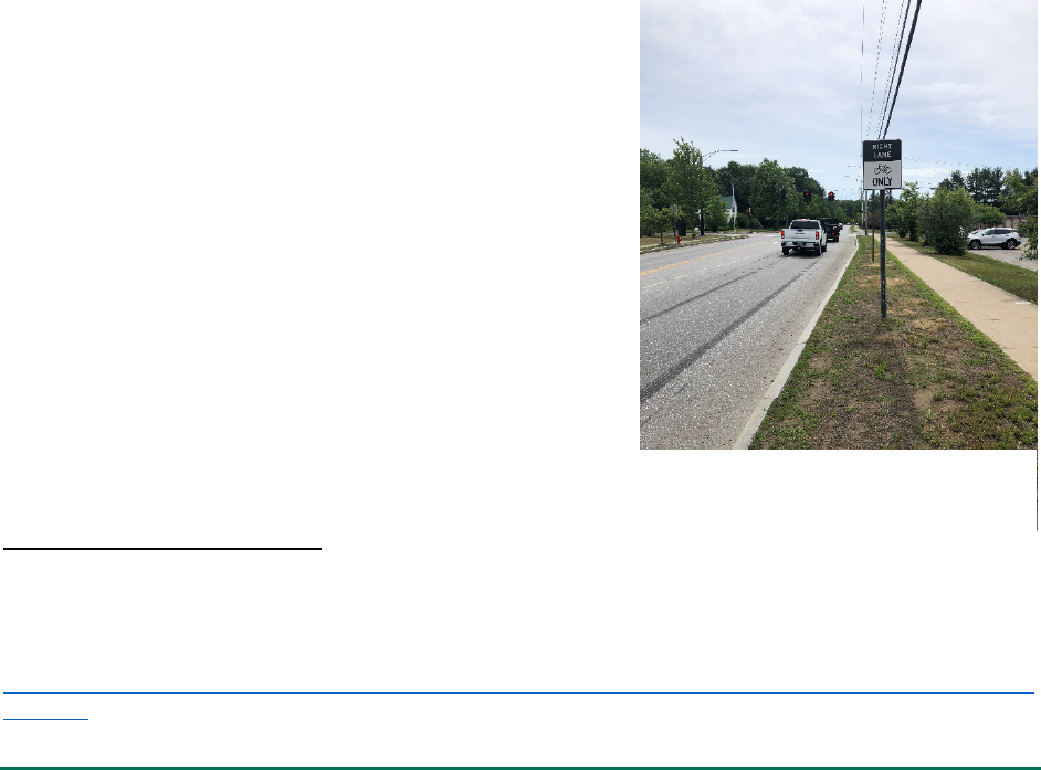
(“sharrows”) or signs indicating bicycle routes as bicycle
infrastructure since there is little evidence of their
effectiveness at increasing bicycling or traffic reducing stress
levels (Mekuria et al., 2017).
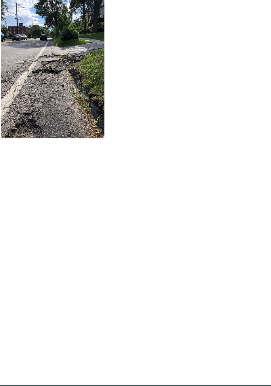
The condition of bicycle facilities was also observed to be
highly variable. We observed many instances of bicycle lane
markings that had completely worn away (see Figure 1 for an
example). The surface condition of most bicycle lanes outside
of Burlington was generally good. Pavement conditions in
Burlington were highly variable, in some cases causing
complete failure of bicycle infrastructure (Figure 2). Many flex
posts were missing from the protected bicycle lane on Union
Street in Burlington which we marked as a buffered bicycle
4
We did not measure and inventory the width of all bicycle infrastructure. This estimate is based on the
measurement of a few spot locations and estimation based on observations while driving proposed ATP network
segments.
5
This includes guidelines in the Vermont Agency of Transportation’s Pedestrian and Bicycle Design Manual:
https://vtrans.vermont.gov/sites/aot/files/highway/documents/publications/PedestrianandBicycleFacilityDesignM
anual.pdf
Figure 1 Faded Bicycle Lane on Kellogg
Road, Essex
UVM Transportation Research Center 6
lane rather than separated. The design of bicycle
infrastructure was also highly variable. The width of bicycle
lanes varied substantially, sometimes within the span of a
single block. While we did not measure the width of bicycle
lanes, some were clearly less than what is generally
recommended in most guidelines (4 ft to 5 ft). Some
roadways only have bicycle lanes on one side of two-way
streets. Shared use paths were sometimes marked with a
center dividing line, sometimes signed as a shared used path,
and sometimes were indistinguishable from sidewalks. We
marked bicycle facilities as present regardless of their
condition and design.
We did not conduct an inventory of intersection treatments
nor did we consider intersections when evaluating the
implementation status of the recommended ATP network
because the ATP had very little information about existing
intersection facilities and few design recommendations. We
observed that many on-road bicycles facilities lacked
treatments at major intersections. The most common
treatment was including a bicycle lane for through movements at intersections that did not have right
turn lanes. Very few intersections had infrastructure to protect bicyclists from right turning traffic or
accommodated left turns. A few intersections in Burlington have bicycle boxes which address some of
these issues, but even in Burlington most do not. Some intersection treatments, such as the intersection
of College St. and Prospect St. in Burlington create dangerous conditions for bicyclists (green right turn
arrow into a bicycle lane that allows through and left bicycle movement). Most intersections do not
have markings that indicate that the traffic control system detects bicyclists and where the bicyclist
should stop to activate the signal. The lack of comprehensive (allowing turning movements) low stress
accommodations for bicyclists at intersections is likely a major deterrent to increasing the amount of
bicycling along many routes included in the ATP.
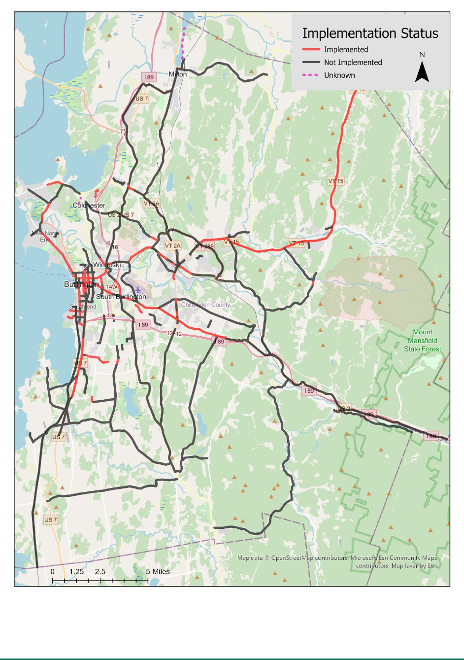
Overall, we observed that 20% (50.2 mi) of the proposed ATP network has been implemented
(considering the limitations discussed above). Figure 3 provides an overview of the proposed ATP
network implementation status, indicating that most of the implementation has been in more urbanized
areas. This may be partially a result of our decision to designate rural roads and highways with shoulders
as not being implemented, even though existing shoulders may have been in response to the ATP.
Appendix A provides a detailed table of roadway segment implementation status, including the type of
bicycle infrastructure provided and notes from our field study. UVM has also created a geospatial
database with this information to facilitate mapping and future updates.
Figure 2 Unmaintained Bicycle Lane on
College Street, Burlingt
on
UVM Transportation Research Center 7
Figure 3 ATP Network Implementation Status as of 2021

UVM Transportation Research Center 8
2.2 Other Infrastructure Recommendations
In addition to the active transportation network, the ATP provides a list of various other infrastructure-
related recommendations organized into three categories: short-term, long-term and engineering. The
large number of recommendations which were often not directed at specific municipalities or corridors
made evaluating their implementation status challenging. We evaluated these by distributing an online
survey to planning and/or public works staff in each municipality, our knowledge (including observations
from our network inventory) and by consulting with CCRPC staff. The electronic survey attempted to
collect information about recommendations that would be difficult or impossible to determine from
evaluating infrastructure or reviewing publicly available documents. The response rate was modest, with
just 8 municipalities out of 18 incorporated municipalities responding. However, the responses did cover
a range of municipality types from urban to suburban to rural and included Bolton, Burlington,
Charlotte, Milton, South Burlington, Underhill, Westford, Williston.
2.2.1 Short Term/Immediate Recommendations
Seven short term recommendations were provided and are summarized in Table 1. Most
recommendations were at least partially implemented. Full implementation would be difficult to
achieve or determine in most cases given the lack of detail provided in most of the recommendations.
For example, one recommendation is to upgrade bike lanes to separated facilities where possible and
another is to develop contraflow bicycle lanes on one-way roads as possible. It is unclear where
conversion to separated bicycle lanes and contraflow bicycle lanes are possible and also where it would
be particularly beneficial. Without an understanding of where recommendations may be possible to
implement it is not possible to understand how widely recommendations have been implemented. A
second challenge is that many of the recommendations are not directed at a specific municipality or
agency and therefore it is unclear who is supposed to implement the recommendation. For example,
one recommendation is to “Work with GMT to ensure...” that all new bus stops include bicycle and
pedestrian facilities and another recommendation is to “Start developing a wayfinding plan...”. In these
examples, it is unclear who is supposed to work with GMT or who is supposed to develop the wayfinding
plan. Without knowledge of who was supposed to implement the recommendation it is difficult to
determine its implementation status. The lack of assigning clear responsibility for implementation of
each recommendation and criteria for where recommended projects should be considered is likely to
limit implementation.

UVM Transportation Research Center 9
Table 1 Short Term Recommendations
Recommendation
Description
Implementation
Status
Notes
Develop wayfinding
plan
Start developing a wayfinding plan now, so that as network segments are built,
signs showing connections can be put into place.
Not Implemented
Wayfinding exists in the region; however, there does not
appear to be any formal plan. Recommendation doesn’t
specify which entity should lead this effort.
Update bike lanes to
separate facilities
Upgrade existing bike lanes to separated bike lanes by adding flex posts (need 5’
bike lane + 1’ buffer) where possible.
Limited
Implementation
1.0 mi in Burlington, although most flex posts are now
missing. Recommendation unclear as to where this is
possible.
Contraflow bike lanes
Develop contraflow bike lanes on one-way streets, and include flex posts as
possible to provide separation from traffic.
Limited
Implementation
0.15 mi in Burlington. Recommendation unclear as to where
this is possible.
Pilot advisory bicycle
lane
Identify a segment on which to pilot an advisory lane. The candidate should be a
road where there is limited width for bicycle facilities and the average daily traffic
(ADT) is less than 6,000 vehicles. Advisory lanes will require significant driver
education and a shift in behavior, so begin with pilot/demonstration projects and
education initiatives prior to implementing on a wide scale.
Implemented
Advisory bike line striped on Flynn Avenue in Burlington.
Unclear if any data collected or if there are plans for further
implementation.
Active travel
infrastructure at GMT
stops
Work with GMT to ensure that all new or updated bus stops include bike racks,
sidewalk connections, crosswalks, and ADA ramps.
Partially
Implemented
GMT reports that 9% of stops have bicycle parking and that
93% have a sidewalk connection. No information on ADA
compliance and crosswalks was provided by GMT. Unclear if
CCRPC or other municipalities have worked with GMT on
implementation.
Bike lane continuity
Ensure that bike lanes are continued through intersections rather than ended at
the approach. Include such designs in intersection improvement studies and plans.
Consult the VTrans Highway Safety & Design Engineering Instructions (HSDEI) 16-
100-Bicycle Facility Design Guidance and VTrans Highway Safety & Design Detail
646.02.
Partially
Implemented
Implemented at most intersections in Burlington, many in
Williston, partial implementation elsewhere. Less continuity
at intersections with turning lanes. A few intersections in
Burlington have bike boxes, but otherwise little
accommodation for left turning bicycle traffic.
Install bike detection
at signalized
intersections
Include bike detection at signalized intersections, and encourage Departments of
Public Works to check that bike detection systems are functioning properly when
doing routine maintenance.
Limited
Implementation
Implementation appears limited to a small set of Burlington
intersections that are on designated bicycle routes.

UVM Transportation Research Center 10
2.2.2 Long-Term Recommendations
Eight longer term infrastructure recommendations were also provided and are described in Table 2.
Most of the recommendations are directed at five major barriers identified during the ATP development
process, although a few are more general. Since most of the recommendations in this section targeted
specific locations and contained more detailed design recommendations, evaluating implementation
status was relatively straight forward. Most of the recommendations focused on the five major barriers
that are being considered in project scoping and design plans as noted in Table 2. It was difficult to
determine the extent to which the recommendation to “focus on separated facilities” has been
implemented given the general nature of this recommendation; however, there are many instances of
separated shared use facilities within Chittenden County which suggests this recommendation has been
at least partially implemented.
The recommendation to consider using level of traffic stress (LTS) to guide planning and design
considerations appears misplaced in this section about long term infrastructure projects. Furthermore, it
is unclear who is supposed to use LTS, how LTS is estimated
6
, and how LTS is supposed to be used to
prioritize and guide the design of projects (we provide recommendations on how to do this in section 4
of this report). Without more specific guidance on how to implement and use an LTS-based prioritization
and design process, it is unlikely to be widely implemented.
6
Various versions of LTS have been proposed and used (Wang et al., 2016). The most common approach contains
four LTS levels and are described in a research report produced by the Minta Transportation Institute (Mekuria et
al., 2017). The ATP references the Minta report but only contains 3 LTS levels.

UVM Transportation Research Center 11
Table 2 Long Term Recommendations
Recommendation
Description
Implementation
Status
Notes
Focus on separated
bicycle facilities
Focus on separated facilities (separated bike
lanes, shared use paths) to attract the greatest
number of potential users.
Partial
Implementation
Similar to short term recommendation of converting bike lanes to separated bicycle lanes.
Separated facilities, mostly shared use paths, have been constructed in many places around
Chittenden County but do not yet create a well-connected network.
Alternate designs for Exit
14 interchange
Consider alternate designs for the Exit 14
interchange, such as a bike-ped bridge (as of
summer 2016, there is a bike-ped bridge scoping
study being conducted for this area).
Under
Consideration
Shared use paths and other separated facilities are included in the I-89 2050 Study Exit 14
alternatives and the I-89 Exit 14 Alternative Transportation Crossing Study. In June 2021 the
City of South Burlington applied to the federal RAISE program for funding to
design/construct a separate bike-ped bridge near Exit 14.
Separated bike lanes thru
the Jughandle at East
Ave, Spear St, and East
Terr
Develop separated bike lanes through the
Jughandle west of Exit 14 at East Avenue, Spear
Street, and East Terrace.
Under
Consideration
Shared use paths and other separated facilities are included in the I-89 2050 Study Exit 14
alternatives and the I-89 Exit 14 Alternative Transportation Crossing Study.
Rebuild Main St. bridge
over Winooski River
Rebuild the Main Street bridge over the
Winooski River between Burlington and
Winooski with separated bike lanes, or build a
separate bike-ped bridge (as of summer 2016,
there is a feasibility study of a separate bike-ped
bridge, and a scoping study of the existing
Winooski-Burlington bridge will be conducted in
spring 2017).
Under
Consideration
The 2019 Bridge Scoping Report includes separated, shared use paths, in each alterative.
Unclear how bicycle travel is accommodated at intersections on either side of the proposed
bridge project, but the 2019 Colchester/Riverside/ Barrett/Mill scoping study identified
walk/bike treatments on the Burlington side of the bridge
Implement bicycle and
pedestrian
improvements in
Winooski Transportation
Master Plan
Add shared use lane markings along Winooski
Falls Way east of the Circulator
Not Implemented
Add shared use lane markings along Cascade
Way north of Winooski Falls Way
Not Implemented
Eliminate merge lane on eastbound East Allen
Street east of Cascade Way and replace with
striped bicycle lane from Cascade Way east for
half a block to tie into the existing bike lane prior
to Abenaki Way.
Not Implemented
East Allen Street Gateway Enhancements Scoping Study provides additional walk/bike
improvements in this area.
Install bike facilities as part of Weaver St
connection from Tigan St to W Allen St
Not Implemented
Construct new bicycle facility (protected bicycle
lanes or striped bicycle lanes) on Weaver Street
with connections to Main St at Tigan St and
West Allen St.
Not Implemented
Bike lane connection exists on West Allen St.
Add shared use lane markings on Abenaki Way
north of Winooski Falls Way
Not Implemented

UVM Transportation Research Center 12
Integrate bike/ped
improvements to
proposed design for Exit
16
Integrate high quality, low stress bicycle and
pedestrian improvements into the proposed
design for the Colchester Exit 16 interchange.
The proposed Diverging Diamond Interchange
includes sidewalks on the East and West sides to
the intersection, with a shared use path on both
sides through the intersection.
Planned for
Implementation
Shared use paths are included in the proposed DDI intersection; however, it is unclear if they
will achieve a high quality and low stress environment given high traffic volumes and
multiple at-grade ramp and intersection crossings. Unclear if bicycle facilities approaching
the DDI will be improved. Unclear if current design alterative meets the intent of this ATP
recommendation. http://www.exit16ddi.vtransprojects.vermont.gov/
Consider developing a
recreation path along the
Circ Highway right-of-
way
Consider developing a recreation path along the
Circ Highway right-of-way. Although a segment
was not recommended in this network because
better transportation connectivity is provided by
parallel alignments, interest was expressed in
charrette discussions in developing such a path.
Not Implemented
Unclear why this recommendation is included here when it was determined that it should
not be included in the proposed ATP network.
Level of Traffic Stress
Analysis
Use LTS analysis to inform decision-making
about project prioritization and design selection.
Unknown
Unclear who is supposed to use LTS, how LTS is estimated, and how LTS is to be used in
prioritization and to inform design.

UVM Transportation Research Center 13
2.3 Engineering
Sixteen engineering recommendations were provided, although many had little to do with engineering
or even infrastructure. For example, this section contained recommendations about snow clearing,
bicycle registration, bicycle infrastructure funding programs, volunteer path “maintenance” events (i.e.
trash and vandalism clean up), and the installation of bicycle maintenance stations. Engineering
guidance should focus on facility design, maintenance and construction issues, such as ensuring that
municipal roadway and intersection design standards address the needs of pedestrians and bicyclists
and incorporate the latest design guidance from state and federal agencies, professional engineering
organizations and other reputable sources. Engineering recommendations could also address
maintenance issues that affect pedestrian and bicyclist infrastructure, geometric design considerations,
and suitable materials and methods for facility construction (i.e., geotechnical engineering).
There were also numerous challenges to determining the implementation status of recommendations in
this section. Similar to the challenges discussed previously, many recommendations lacked sufficient
information about where recommendations should be implemented and almost all recommendations
failed to identify who should be responsible for their implementation. For example, count down timers
should be encouraged where applicable – but no guidance is provided about where they are applicable
nor is it clear who is to perform the encouragement, what encouragement means, or if financial or
technical assistance is available. We considered recommendations implemented or partially
implemented (most cases) if we could identify examples of their implementation in Chittenden County
although we were unable to determine if implementation was in response to the ATP or pre-dated the
ATP.

UVM Transportation Research Center 14
Table 3 Engineering Recommendations
Recommendation
Description
Implementation Status
Notes
Pedestrian
easements
Encourage municipalities to request pedestrian easements
and connections between developments during site
review (where applicable).
Partial Implementation
Unable to determine if encouragement was provided. However, several
municipalities indicated in our survey that they sometimes request easements, 1
always requests easements and 3 were unsure or stated that they did not.
Snow clearing
Encourage municipalities (where applicable) to assume
responsibility for clearing snow from sidewalks and paths
(if they don’t already).
Partial Implementation
Unable to determine if encouragement was provided. Most municipalities that
have public sidewalks clear them according to our review of municipal policies and
survey responses. A few do not clear snow and some only clear snow on select
sidewalks. Burlington does not clear all shared use paths to allow for winter
recreation.
Bicycle
registration and
parking
Review municipal ordinances related to bicycle
registration and parking. Ordinances should encourage
bicycling and protect bicycles and bicyclists rather than
discourage use. New developments should be encouraged
or required to provide bicycle parking, including parking
for cargo bikes, on-site. Refer to the Association of
Pedestrian and Bicycle Professionals (APBP) Essentials of
Bicycle Parking.
Partial Implementation
Unable to determine who is responsible for reviewing and if a review was
completed. According to our survey, some municipalities have bicycle parking
requirements. Burlington has an entire chapter dedicated to bicycle ordinances. We
did not review municipal policies to identify ordinances that encourage or
discourage bicycle use.
Fund VTrans Bike-
Ped programs
Continue to provide funding programs like the VTrans
Bicycle and Pedestrian Program to support construction of
local bicycle and pedestrian infrastructure. VTrans
Transportation Alternatives Program (TAP) funding also
supports bicycle and pedestrian infrastructure.
Implemented
This recommendation is for continuing existing state and federal funding programs.
Regularly review
posted speed
limits
Review posted speed limits regularly. Traditionally, speed
limits have been set according to the 85th percentile
speed at which traffic travels. However, speed limits can
and should be set according to the specific set of
conditions experienced on that roadway, and using
engineering judgement. When conducting safety or
infrastructure improvement studies, planners and
engineers should refer to
http://safety.fhwa.dot.gov/uslimits/ to determine
whether a road’s speed limit is set appropriately.
Partial Implementation
Most municipalities responding to our survey stated that they review speed limits
based on a variety of considerations. Frequency of review is variable. It is unclear if
current practice has changed in response to the ATP or since its publication. We did
not evaluate if municipalities us the FHWA speed limit tool.
Active
transportation
access to transit
Coordinate with GMT to improve active transportation
access to transit stops. Improvements may include
upgrading signage, installing shelters or seating, lighting,
route maps, and schedules.
Partial Implementation
Unclear who is supposed to coordinate with GMT. This recommendation generally
overlaps with a similar recommendation in the short-term recommendations. Some
of these items have been implemented at various stops but its unclear/unlikely that
they are all appropriate at all stops.

UVM Transportation Research Center 15
Develop a rural
walking toolkit
Walking infrastructure might look different in rural areas
compared with urban areas. Sidewalks sometimes seem
out of place in rural areas, but that doesn’t mean that
opportunities for walking shouldn’t be provided. A toolkit
that describes how to advance rural walking alternatives
like meandering soft surface paths would likely help towns
in Chittenden County.
Not Implemented
Unclear who should develop the toolkit and what the toolkit would consist of. Is
new research required or can existing FHWA and other existing design guidance be
referred to? Soft surface paths may not be useful during winter and spring (mud
season).
Inventory curb
ramps and assess
condition
Inventory curb ramps and assess their condition, including
locations where they are missing. Curb ramps are an
essential part of the pedestrian network to ensure
accessibility for all.
Partial Implementation
Unclear who is to perform the inventory. Only Burlington stated this as a regular
practice in our survey. The focus on curb ramps only addresses one aspect of ADA
standards (one that is specifically required by DOJ/DOT when roadways are
improved). For sidewalks to be accessible to people with disabilities, they also must
be wide enough, free of obstacles, be relatively level, provide a durable surface free
from significant defects (e.g., cracks, holes and raised slabs) and buttons to active
signals should be accessible as well. See
https://www.fhwa.dot.gov/environment/bicycle_pedestrian/publications/sidewalk
s/chap4a.cfm, http://www.bikewalk.org/pdfs/sopada_fhwa.pdf, and
https://www.access-board.gov/guidelines-and-standards/buildings-and-
sites/about-the-ada-standards/ada-standards/chapter-4-accessible-routes for more
information on ADA design guidelines and standards applicable to sidewalks.
Develop a
pedestrian
maintenance
toolkit for local
DPWs
Most municipalities in Chittenden County already do an
excellent job at maintaining sidewalks, crosswalks, and
curb ramps. Still, providing checklists and documenting
innovative approaches to maintenance and facilities may
assist them in planning budgets and allocating resources.
Not Implemented
Unclear who should develop the toolkit and what the toolkit would consist of.
While we did not evaluate the quality and condition of bicycle and pedestrian
infrastructure as part of this project, we did observe many instances of poorly
maintained pedestrian and bicycle facilities. Many on-road bicycles facilities had
faded or missing lane markings when we inventoried them in late spring and early
summer. Some bicycle facilities, particularly in Burlington, had very poor pavement
conditions. A large number of sidewalks in Burlington were observed to be in poor
condition.
Portable ramps
for local
businesses
Encourage local businesses to provide portable ramps to
accommodate wheelchairs over raised/inaccessible
doorways. Portable ramps are a low-cost way to provide
wheelchair access to businesses with a step or small
barrier to entry.
Unknown
Unable to determine if encouragement was provided. Unclear who would be
responsible for encouraging this and how encouragement would be provided.
Volunteer path
maintenance
events
Maintenance might include trash pickup, sweeping,
cleaning of vandalism, and reporting areas in need of more
serious maintenance.
Unknown
Unclear who is responsible for implementing this and if it occurs. It is also unclear
why volunteers should be expected to perform what is typically (and currently) a
municipal function.
Countdown
timers & leading
ped intervals at
crosswalks
Encourage municipalities to require countdown timers and
leading pedestrian intervals (where applicable) at all
crosswalks.
Partial Implementation
Unable to determine if encouragement was provided. Unclear who is responsible
for encouragement and how encouragement would be provided. Unclear where
countdown timers and LPIs are/are not applicable. Both strategies have been
implemented in multiple municipalities across Chittenden County to various
degrees based on responses to our survey. Implemented at most intersections in
Burlington.

UVM Transportation Research Center 16
Require
installation of
wheel guards on
fleet trucks
Work with municipalities to require installation of wheel
guards on fleet trucks. Wheel guards prevent pedestrians
and bicyclists from being pulled under the wheels of heavy
vehicles in a crash. Municipalities can retrofit fleet vehicles
operated by or under contract with the municipality, such
as waste removal, construction or maintenance vehicles.
Not Implemented
Unclear who is responsible for working with municipalities on this
recommendation. No municipalities acknowledged adopting this in our survey.
There may be some merit to this recommendation but this does not appear to be a
widely implemented safety countermeasure and therefore will likely require
significant outreach and education.
Public bike
maintenance
stations (fix-it
stations)
Support the installation of public bike maintenance
stations. Public maintenance stations allow bicyclists to fill
tires with air and complete minor repairs. These stations
offer convenience to bicyclists and increase the visibility of
bicycling in the community.
Partial Implementation
Unclear who is responsible for supporting this and what the support consists of?
Financial support? Some stations exist in the county at a mix of public and private
business locations:
https://www.localmotion.org/bike_repair_stations.
Seek state
guidance on
proper design
applications
Consult the VTrans Highway Safety & Design Engineering
Instructions (HSDEI) for guidance on proper design
applications: HSDEI 12-001-Complete Streets Guidance,
HSDEI 15-100-Guidelines for Pedestrian Crossing
Treatments, and HSDEI 16-100-Bicycle Facility Design
Guidance.
Unknown
Unable to determine to what extent municipalities consult these guidelines or if
their consultation of guidelines has changed in response to the ATP.
Consider modern
roundabouts
Consider modern roundabouts in appropriate contexts
(usually urban areas) as effective ways to calm traffic and
improve safety, particularly for people who are walking
and bicycling.
Partial Implementation
Several municipalities responded to our survey that roundabouts are considered.
CCRPC also provides some design guidance: https://www.ccrpcvt.org/our-
work/transportation/transportation-resources/roundabouts/.

UVM Transportation Research Center 17
2.4 Non-Infrastructure
The non-infrastructure recommendations were organized into four categories: education,
encouragement, enforcement, and evaluation. We evaluated the implementation status of each
recommendation by searching the websites of local, regional and state government agencies and
organizations that partner with CCRPC to identify documents and policies indicating implementation of
each recommendation. We also collected information through an electronic survey distributed to each
municipality’s planning and public works staff. Evaluating the implementation status of the non-
infrastructure recommendations was challenging because of the very large number and diversity of
these recommendations combined with little information about who should be implementing them. The
recommendations and their implementation status are summarized in Tables 4 - 7.
UVM Transportation Research Center 18
Table 4 Education Recommendations
Recommendation
Description
Implementation
Status
Notes
Motorist Education
Work with the Vermont Department of Motor Vehicles to
ensure that driver education includes a significant
component on interaction with bicyclists and pedestrians.
Focus on the importance of appropriate speeds and
attentive driving.
Partially
Implemented
Unclear who is responsible for implementing this and if outreach to DMV
occurred. VT Driver's Manual (2019) has a section on sharing the road with
bicycles. Other vulnerable users that drivers should look for are frequently
mentioned in the manual:
https://dmv.vermont.gov/sites/dmv/files/documents/VN-007-
Drivers_Manual.pdf
Driver's Manual Interactive training also includes components on bike/ped
interactions:
https://dmv.vermont.gov/driver-training
Local Motion Every-
day Bicycling Project
(EBP) Classes
Promote Local Motion’s “Everyday Bicycling” course. This
course will help adult bicyclists learn bicycle safety,
etiquette and the rules of the road.
Implemented
Unclear who is to promote this beyond Local Motion? CCRPC provides funding to
support Local Motion's bicycle advocacy and education efforts.
Provide educational
materials on bike/ped
rules
Provide educational materials on bicycle and pedestrian
rules, safety and etiquette to drivers, bicyclists, and
pedestrians. VTrans and Local Motion have printed
materials that municipalities and other agencies can
distribute.
Implemented
Unclear if the intent was to distribute materials beyond what is currently done
by Local Motion? CCRPC provides funding to support Local Motion's bicycle
advocacy and education efforts.
https://www.localmotion.org/rules_of_the_road
Targeted outreach and
education to schools
and colleges
Educational materials can be targeted at students in
schools and colleges with information about rights and
responsibilities as well as safety.
Unknown
Unclear who is responsible for providing these materials and outreach to
schools.
Launch pedestrian
awareness campaign
Launch a public awareness campaign focusing on yielding
to pedestrians at crosswalks and driving slowly. Local
media and public service announcement can be used to
implement the campaign
Not Implemented
Unclear who is responsible for producing the campaign? We are unaware of any
campaigns.
Workshops, training
for local officials
Offer workshops and training courses to local staff and
elected officials to communicate the importance of
walking, pedestrian safety, and how design can impact
both.
Unknown
Unclear who is responsible for creating and providing workshops and training.
UVM Transportation Research Center 19
Table 5 Encouragement Recommendations
Recommendation
Description
Implementation
Status
Notes
Encourage healthcare
providers and insurers to
prescribe active
transportation, as
appropriate
Providers can write prescriptions for 20 minutes of
daily walking or discounted bicycle helmets to
encourage patients to walk and bicycle for health.
Not Implemented
Unclear who would implement this. Presumably providers would need to
determine appropriate level of physical activity for patients depending on their
health condition. Unclear who would be funding or creating a program for
discounted bicycle helmets. Unclear that bicycle helmet availability is a barrier to
bicycling.
Walk- and Bike- Friendly
Communities designations
Encourage municipalities to renew or apply for Walk-
and Bike- Friendly Community designations from the
League of American Bicyclists and the Pedestrian and
Bicyclist Information Center
Partially
Implemented
Unclear who is to provide encouragement and if this has occurred; however, Local
Motion has previously helped communities apply. Burlington and Essex Junction
are designated. According to survey responses, some municipalities are interested
in designation but it appears that outreach has not occurred recently.
Promote TDM strategies
Continue to promote transportation demand
management (TDM) strategies and participation in
organizations such as the Chittenden Area
Transportation Management Association (CATMA).
Implemented
CCRPC is a CATMA member and provides funding to CATMA. CCRPC's other TDM
partners are listed here: https://www.ccrpcvt.org/our-
work/transportation/transportation-demand-management-park-ride/#tdm-
partners. The City of Burlington also has TDM requirements in city ordinances:
https://www.codepublishing.com/VT/Burlington/#!/html/BurlingtonAxA/Burlingt
onAxA08.html
Support schools in making
walking and biking part of
everyday
Safe Routes to School participation can take the form
of organizing annual walk events (such as
International Walk to School Day), data collection,
walking school buses, bike trains, walking and biking
curricula, and monthly walk to school events.
Implemented
VTrans funds the program as part of its Bicycle and Pedestrian Program and Local
Motion runs it. The program will be “re-launched” this year.
https://saferoutes.vermont.gov/
Way to Go! Has also recently focused on walking, biking and rolling to schools.
www.waytogovt.org
Consider a bike share pilot
program in Chittenden
County
Local Motion’s 2012 feasibility study notes that bike
share may be feasible in Burlington and Winooski.
Planning for a pilot bike share system is underway by
CATMA, UVM and Champlain College for launch in
2017.
Implemented
E-bike share implemented in summer 2021, replacing prior version that used
conventional bicycles. http://greenridebikeshare.com/
Promote the Bicycle Benefits
program
Promote the Bicycle Benefits program to local
businesses and their patrons. The Bicycle Benefits
program offers shoppers who bike to participating
merchants a discount on their purchases.
Implemented
This program exists. Unclear who promotes it.
https://www.facebook.com/BicycleBenefitsVermont &
http://bicyclebenefits.org/cities/15 &
https://www.localmotion.org/bicycle_benefits
Municipal pedestrian
advisory committees
Encourage municipalities to develop a pedestrian
advisory committee if appropriate and/or if they do
not already have one.
Partially
Implemented
Unclear who is responsible for encouragement, if encouragement has occurred,
and where this would not be appropriate. Seven municipalities have bike/ped or
alternative transportation or mobility committees. Five municipalities have
energy, trails or recreation committees that work on sustainable transportation
issues. Five municipalities don't have any relevant committees (Buel's Gore not
included). Local Motion also does a lot of work with municipal bike/ped
committees.
Adopt Vision Zero strategy
Encourage municipalities (where applicable) to adopt
Vision Zero to prioritize safety for vulnerable users.
Limited
Implementation
Unclear who is responsible for encouragement and if encouragement has
occurred. Where is it not applicable? No communities have adopted this.
Burlington is only community to respond to the survey indicating they are
considering this.

UVM Transportation Research Center 20
Participate in PARK(ing) Day
Participate in PARK(ing) Day (the third Friday in
September) on a county-wide basis. On PARK(ing)
Day, parking spaces are transformed into parklets to
convey the importance of open space and public art,
and reinforce the importance of people over parking.
Not Implemented
Unclear who is responsible for coordinating this. Some municipalities have piloted
transforming parking spaces into parklets and outdoor dining.
Table 6 Enforcement Recommendations
Recommendation
Description
Implementation
Status
Notes
Bicycle and Pedestrian
Training courses
Promote the Bicycle and Pedestrian Training course offered by the Vermont
Police Academy and Local Motion. This course aims to help law enforcement
officers understand the rights and responsibilities of bicyclists and pedestrians.
Chittenden County may also consider creating new educational materials, such as
Massachusetts Bicycle Coalition’s bike safety video, which works collaboratively
with police officers on bicycle issues: https://www.youtube.com/embed/
hhkEb0ie7Cg/
Unknown
Unclear who is responsible for implementation and if
promotion has occurred.
Develop speed
reduction program
Develop a speed reduction program to strengthen enforcement and assure that
vehicle speeds are safe for Complete Streets and vulnerable users such as
bicyclists and pedestrians. A comprehensive speed reduction program may
include speed feedback trailers.
Partially
Implemented
Unclear who is responsible for implementing this program.
Many communities are using speed feedback signs/trailers
based on responses to our survey. Unclear if this has been
in response to the ATP and if other measures have been
taken.
Positive reinforcement
Focus on positive reinforcement, such as recognition for safe and slow driving,
yielding to pedestrians, bicyclists who signal their turns, and looking both ways
before crossing the street. Police in some communities hand out coupons for free
coffee to people who are observed practicing safe behavior.
Not Implemented
Unclear who is responsible for implementing this program.
Appears aimed at local police departments but its unclear if
they are at all aware of this recommendation. Unclear how
police would provide positive reinforcement to people who
are driving? Local Motion used to provide incentives to (free
ice cream coupons) to courteous drivers (e.g., yielding to
pedestrians at crosswalks).
Municipal ordinance
review of town-wide
speed limits
Review municipal ordinances to determine if a town-wide speed limit or a
reduction in the town-wide speed limit would be appropriate. In 2011, Burlington
reduced its city-wide speed limit from 30 mph to 25 mph. Reducing the speed
limit not only improves safety, but provides officers with a stronger basis for
enforcement.
Not Implemented
Unclear who is to conduct this review and what criteria
would be used to determine when a town-wide speed limit
or reduction is warranted. Only Burlington has a town wide
speed limit that we are aware of.
Public safety &
enforcement campaigns
Work with local police on public safety and enforcement campaigns (where
applicable).
Unknown
Unclear who is to work with police and what the
relationship involves? Unclear where a public safety and
enforcement campaign would/would not be applicable?
Enforce pedestrian
right-of-way
Work with local police and code enforcement to enforce pedestrian right-of-way
obstructions, such as blocking a sidewalk with a parked car or a sandwich board.
Unknown
Unclear who is to work with police and what the
relationship involves?
UVM Transportation Research Center 21
Table 7 Evaluation Recommendations
Recommendation
Description
Implementation
Status
Notes
Develop a robust
bicycle and pedestrian
count program.
Evaluate long-term trends
Under
Consideration
CCRPC is working with the University of Vermont Transportation Research
Center to improve its bicycle count program to address this recommendation.
Forecast bike/ped volumes of a particular facility
Not Implemented
Would require updating the regional travel demand model or implementing
another forecasting method. There are a wide range of demand forecasting
methods; however, most are either too simplistic to be useful or would
require significant data collection and statistical and/or spatial analysis work.
An overview of methods is provided in this report:
https://www.pedbikeinfo.org/cms/downloads/PBIC_WhitePaper_Forecasting.
pdf
Separate bicycle and pedestrian in traffic models
Not Implemented
Would require a significant update to the regional travel demand model.
Identify network gaps
Partially
Implemented
CCRPC is working with the University of Vermont Transportation Research
Center to improve its bicycle count program. Part of this work is identifying
gaps in bicycle count data. Pedestrian count data are not the focus of the
UVM study.
Help define a hierarchal network (for example, functionally
classify bike facilities and corridors)
Under
Consideration
CCRPC is working with the University of Vermont Transportation Research
Center to improve its bicycle count program to address this recommendation.
Acquire data to support performance measures that inform
project selection and close data gaps
Under
Consideration
CCRPC is working with the University of Vermont Transportation Research
Center to improve its bicycle count program to address this recommendation.
Measure the return on investment of new facilities
Not Implemented
Improved bicycle count program could help implement this.
Develop a better understanding of how weather affects active
transportation
Not Implemented
Improved bicycle count program could help implement this.
Advance projects
recommended in this
regional plan in VTrans
Transportation
Alternatives & Bike-Ped
Programs
That is, projects that are being considered for funding should
rank higher if they are consistent with regional planning
initiatives.
Implemented
Guidance for 2021 TAP applicants states that projects score higher if they are
part of an existing plan (although not necessarily a regional plan):
https://vtrans.vermont.gov/sites/aot/files/highway/documents/ltf/TA%20Pro
gram%20Summary-Application%20Guide%20SFY%202021.pdf. Guidance for
VTrans small-scale bicycle and pedestrian grants awards more points if
projects complete a gap in a bicycle or pedestrian network or are
demonstrated as a high need via an existing planning document:
https://vtrans.vermont.gov/sites/aot/files/highway/documents/ltf/2021%20S
mall-scale%20BikePed%20Grant%20Guide.pdf
Develop a smart phone
app for reporting issues
Develop a smartphone app for reporting maintenance or
safety issues. Communities have streamlined public works
operations and customer service by enabling users to report
potholes, broken pedestrian signal buttons, and other hazards
through their mobile devices.
Partially
Implemented
Unclear who is supposed to develop this? CCRPC or municipalities? Several
communities have apps and websites to report issues.

UVM Transportation Research Center 22
Develop local walking
plans
Develop local walking plans for each community in Chittenden
County. Not only would documenting this ubiquitous mode
raise its visibility and help residents to understand its
importance, but formalizing a town’s walking network will help
to identify gaps, maintenance issues, and opportunities for
improvement.
Partially
Implemented
Six municipalities have plans that at least include walking. Other
municipalities either have plans in development or do not have plans.
Conduct annual
walking audits
A walking audit is a method to determine if neighborhoods or
specific routes meet walkability criteria, such as safety,
connectivity, accessibility, comfort, cleanliness, and
maintenance. Walk audits should be completed near schools
or other high demand locations.
Unknown
Unclear who is responsible for implementing this.
Create walking maps
Create walking maps for towns to promote walking. This
recommendation could be completed concurrently with the
local walking audits described above.
Not Implemented
Unclear who is responsible for implementing this.
Pedestrian surveys
Survey pedestrians periodically to identify both barriers and
gaps in walkability.
Not Implemented
Likely happens as part of specific projects, but not in general. Unclear why
bicyclists are excluded from this recommendation?
Enhance the CCRPC
bike-walk count
program
The 2013 FHWA Traffic Monitoring Guide notes that a program
that combines both short- and long-term counts is best to
gather spatial and volume information. For short-term counts,
volunteers can count bicyclists and pedestrians an hour or two
at a time, while permanent, automated counters can collect
volumes continuously throughout the year. From these data,
regional long-term trends can be identified and hourly, daily,
and seasonal adjustment factors developed. Adjustment
factors are then used to calibrate or extrapolate short-term
counts performed at a wider variety of locations.
Under
Consideration
Similar to first recommendation, develop a robust count program. CCRPC is
working with the University of Vermont Transportation Research Center to
improve its bicycle count program to address this recommendation.

UVM Transportation Research Center 23
3 EVALUATING THE PLANNING AND PRIORITIZATION PROCESS
In addition to evaluating the implementation status of each ATP recommendation, we were charged
with developing a strategy to prioritize and implement the remaining ATP recommendations. To
accomplish this task, we began by evaluating the data and methods used to develop and prioritize the
ATP’s recommendations. We read the current plan and reviewed its appendices, both of which were
provided to us by CCRPC (the main active travel plan document is also available on CCRPC’s website
7
).
We focused on identifying the data and other sources of information used to develop the plan, the
methodology used to translate these data and other information into a set of prioritized
recommendations and information on how the plan’s outcomes will be evaluated. We evaluated this
information to identify opportunities to improve the prioritization process and a strategy to implement
the plan’s remaining recommendations. Since our evaluation uncovered concerns regarding both the
methods and data used to develop the ATP recommendations in addition to the prioritization process
(ideally the two are closely connected), some of our recommendations extend beyond improving just
the project prioritization process and implementation strategy and focus more broadly on the ATP
planning process. Some of these recommendations are provided to help inform future iterations to the
region’s ATP.
3.1 Proposed ATP Network
The proposed ATP network is the most significant product of the ATP planning process. The proposed
ATP network identifies travel corridors consisting of streets, highways and paths that could be improved
to create a regional bicycle network. The ATP uses separate methods and data to identify the proposed
ATP network and rank the priority and feasibility of each segment. Our review revealed important
limitations in both the ATP planning and prioritization process.
3.1.1 Developing the Proposed ATP Network
The proposed ATP network was identified using a 3-step process
8
.
1. Barriers: Network segments were drawn through locations identified by the public as being a
barrier to walking or bicycling. Public input was collected through an on-line wiki map and a
series of charrettes.
2. Origin-Destination Density: The density of origins (residential addresses) and destinations (non-
residential addresses) were used to identify additional network segments. Segments were
drawn through high origin-destination density areas that did not include existing low-stress
facilities. Low stress routes were identified using a level of traffic stress (LTS) model
9
.
3. Segments Included in Prior Plans and Studies: Segments included in prior plans were gathered
together and then “refined” to focus on low-stress and regional connections.
The primary purpose of a transportation system is to provide people access to destinations where they
engage in various activities and obtain goods and services. The transportation system is also used by
businesses to move goods and provide services. The design of transportation systems should therefore
7
Chittenden County Active Transportation Plan (2017): https://www.ccrpcvt.org/wp-
content/uploads/2016/01/OFFICIAL_CCRPC_REVISED-4_13.pdf
8
See section 5.2 of the ATP.
9
The LTS analysis is described in ATP report section 5.1; however, the sources of data and calculation methods are
not described or referenced. Since the Mineta Transportation Institute first proposed the LTS methodology,
multiple versions of the process have been developed and used.

UVM Transportation Research Center 24
generally focus on providing or increasing accessibility. Ensuring more equitable access for all population
groups to destinations has also become a greater planning priority. Performance measures are used in
transportation planning to evaluate current conditions and to what extent proposed transportation
plans may improve them. Performance measures should include those that measure accessibility and
often include other important outcomes including environmental impacts, safety and those related to
motor vehicle mobility (e.g., congestion levels, average speed, travel times). Bicycle and pedestrian
plans should also be designed to increase accessibility and ensure equitable outcomes. People may also
engage in bicycling, walking and other types of active travel solely for recreation or exercise. Purely non-
transportation bicycle and walking trips do not necessarily require access to destinations, but access to
infrastructure that supports these activities should be considered. In most cases, active travel
infrastructure that provides greater accessibility also provides more opportunities for recreation and
exercise.
Accessibility can be measured in many ways, but most methods are focused on quantifying the network
distance between where people live to various destinations (often a set of frequently accessed or
important destinations like employment, schools, grocery stores, and public services). When evaluating
accessibility for vulnerable roadway users such as pedestrians and bicyclists, it is also important to
consider additional factors that may limit accessibility such as the lack of appropriate infrastructure and
vehicle traffic conditions. Since some roadways may be less favorable for walking and bicycling, the
accessibility provided by a roadway network may be different for people traveling by different modes.
LTS has become a popular method for evaluating which network links are more favorable to bicycling
than others (Mekuria et al., 2017; Wang et al., 2016) and can be used in the calculation of bicycle
accessibility (Kent & Karner, 2019).
The data and methods used to develop the proposed ATP network consider some aspects of
accessibility, but there are significant gaps.
In the first step of the process, the identification of barriers to active travel along routes used by cyclists
and pedestrians provides information that can be useful for improving accessibility. Barriers to walking
or bicycling were collected from the public through a wiki-map and a series of charrettes. However,
these data should be used with caution and in a limited capacity. While no information was provided
about how participants were recruited to the wiki-map or charrettes, it is very likely that participants
opting to provide information through these forums are more likely to be frequently engaged in active
travel than the general population. People with greater experience and confidence in walking and
bicycling may have different infrastructure preferences and opinions about what constitutes a significant
barrier to active travel. While the barriers identified through the public process may be important
deterrents to bicycling and walking for all, participants in these forums may not have identified barriers
that currently deter most people from engaging in active travel. Additionally, it is unclear how
representative the data collected through the public process is. While some wiki map participant data
was collected, including age, gender and home zip code, these data are insufficient for understanding
how representative the participants were of current and potential network users or the general
population. This raises questions about how well the data collected reflects the barriers facing diverse
populations including households with young children, households without access to vehicles, workers,
students, BIPOC, lower income households and communities in various geographic areas if the region.

UVM Transportation Research Center 25
Residential and non-residential addresses were used in step 2 of the ATP network development process
to determine where additional low stress infrastructure is required. While very little explanation is
provided in the ATP about how address data were used in this step, it appears
10
that they were a used to
create an address density map. New active travel network links were then drawn within high density
areas that did not have low stress routes or to connect various high-density areas together that
currently lacked low stress connections – or possibly both of these objectives. At best, this process
prioritized locating new ATP network links in higher population density areas which has some
relationship to accessibility. However, the use of non-residential addresses for identifying trip
attractions is inappropriate because there is extreme variability in the number of trips attracted to
different non-residential addresses. For example, the University of Vermont or Global Foundries attract
thousands of daily commute trips while other businesses may only attract a handful. While placing
additional infrastructure within or between higher population density areas can improve accessibility, it
does not explicitly evaluate how improvements change the distances people must travel to reach
important destinations from their homes using active transportation infrastructure. High population
density areas may not have many important destinations (e.g., suburban housing developments) while
low population density areas may contain important destinations (e.g., major employers, medical
services or government institutions located in industrial parks or urban cores that lack residential land-
use). The address density approach used in the ATP also fails to consider the patterns of trip making that
people make in the region and the portion of trips that fall within a distance range generally considered
walkable or bikeable.
3.1.2 Prioritizing ATP Network Projects
Proposed ATP network links were ranked along two dimensions: priority and feasibility. Priority was
evaluated based on three criteria
11
:
1. Serves a Population in Need: Serving a population in need is defined as a project being located in
an area of very low to moderate opportunity
12
or within 100ft of a bus stop or within half a mile
of a school (including colleges).
2. Addresses Bicycle and Pedestrian Crash Locations: A project that addresses a high bicycle or
pedestrian crash location is defined as intersecting a location where more than one bicycle or
pedestrian crash occurred between 2008 and 2012.
3. Closes a Bicycle and Pedestrian Gap: This criterion is met if the project addresses a previously
proposed sidewalk or is in a walkable area that currently has no existing pedestrian
infrastructure and is in a location with no existing bicycle facilities (bicycle facilities include
paved shoulders, bike lanes and off-street paths).
Projects were assigned priority scores of low, medium or high based on if they met one, two or all three
of the above criteria, respectively.
Feasibility was evaluated separately for rural and urban areas and assigned scores of low, medium and
high. Rural feasibility depends on right-of-way availability and “topographical constraints”. It is unclear
what defines a topographical constraint and its various levels. Projects where there is no available right-
10
Based on Figure 15 in the ATP.
11
Defined in Appendix G of the ATP.
12
Using HUD opportunity index at the Census Tract level which accounts for the poverty rate, school proficiency,
homeownership rate, unemployment rate, and job access.

UVM Transportation Research Center 26
of-way or many topographical constraints are scored as low feasibility while those with fewer
topographical constraints and available right-of-way are scored as medium or high feasibility. Feasibility
in urban areas was scored based on the amount of “operational change” required. Greater operational
change is generally defined in the ATP as a project that requires reallocating more space to active travel
or requiring more construction.
The current prioritization criteria consider safety and some aspects of accessibility and equity.
The first criterion relates to equity and aims to prioritize projects for populations in need by focusing on
disadvantaged communities, access to education, and access to transit. An important limitation in this
part of the prioritization process is that projects are prioritized based on where they take place rather
than on projects that most increase accessibility for populations in need. The location of disadvantaged
communities or important destinations is not necessarily where the most beneficial network
improvements are required to provide greater access to important destinations for these populations.
For example, an important route from a low opportunity census tract to employment opportunities may
pass through a mixture of low and high opportunity census tracts. If network improvements along the
route are required in higher opportunity census tracts, they would not be prioritized, even if they
represent the largest barrier to improving access for low opportunity zones. Similarly, access to transit
requires safe and accessible pedestrian and low stress bicycle routes that extend from where people
begin their trips to where they reach a transit stop. Only prioritizing projects within 100ft of a transit
stop excludes most of the route a pedestrian or bicyclist would need to travel and may exclude
important transit access barriers from being prioritized. Similar issues occur when prioritizing routes to
education within half mile of schools. A second limitation of this part of the prioritization process is that
it does not consider existing levels of accessibility or the magnitude of potential improvements. Some
low opportunity census tracts may have much worse accessibility than others and some projects may
improve accessibility for a larger population in need than others. A final concern with identifying
disadvantaged communities using low opportunity census tracts is that the geographic extent of a
census tract is relatively large and varies with population density. This may make it difficult to identify
populations in need within lower density regions. Similarly, there is also the risk of prioritizing projects in
high opportunity areas within lower opportunity zones.
The second criterion considers safety by prioritizing projects where pedestrian or bicycle crashes have
previously occurred. Projects are prioritized if they pass through locations where more than one
pedestrian or bicyclist crash has occurred during a four-year period. The use of crash data is appropriate,
although it is important to consider some of the limitations in these data. Since relatively few people
make bicycle trips or walk in most places in the region, the location of crashes that occurred over a four-
year period is unlikely to identify all areas that pose significant crash risks. The probability of a crash in a
particular location, even a dangerous location, is relatively small when there are few pedestrians or
cyclists (e.g., exposure is low). Locations with more frequently observed crashes may be more
dangerous (higher probability or risk of a crash) or they may be places with more pedestrians or cyclists.
While prioritizing projects that address locations with frequent crashes is clearly important, it is also
important to consider that high crash frequency locations may not be the only high crash risk locations.
Between 20% to 90% of bicycle and pedestrian crashes are not reported (Elvik & Mysen, 1999; Sciortino
et al., 2005; Shinar et al., 2018; Winters & Branion-Calles, 2017) and near misses are very common but
little data is collected on them (Aldred, 2016; Aldred & Goodman, 2018; Medury et al., 2019; von
Stülpnagel & Krukar, 2018). Furthermore, some recent research suggests that places with very few

UVM Transportation Research Center 27
crashes may be among the most dangerous since safety concerns keep most active travel users away
from these locations, limiting exposure and therefore crashes (Ferenchak & Marshall, 2019). In addition
to gaps in crash and near-miss data, evaluating pedestrian and bicyclist crash risk is also complicated by
the need for exposure data which does not exist for most crash locations and time periods. Acting on
the recommendations in the ATP to increase bicycle and pedestrian data collection could therefore also
help better identify safety concerns.
The third prioritization criterion requires that projects address both pedestrian and bicycle barriers.
Projects must take place in a location without any pedestrian AND bicycle infrastructure. The intent here
appears focused on increasing accessibility in places with no current active travel infrastructure;
however, the criterion is only weakly linked to accessibility since network connectivity and access to
destinations are not considered. This is also a very limiting criteria, particularly in more urbanized
municipalities and town centers where active travel opportunities are greatest – if high quality
infrastructure are provided. For example, by this criterion, almost no project in Burlington could receive
the highest priority since most streets have sidewalks. This is also a curious criterion since the ATP
network is focused on bicycle transportation. Furthermore, the prioritization of projects does not appear
to have followed this criterion, since most projects in Burlington received the highest priority ranking
despite taking place along routes with sidewalks.
13
The feasibility of gaining public acceptance and constructing a project is also an important and practical
consideration. While the qualitative evaluation of potential project feasibility offers a reasonable high-
level analysis, it is unclear how the feasibility rankings can or should be used when prioritizing or
implementing the recommended projects. Should high feasibility projects precede low feasibility
projects? To a large extent, feasibility is related to project complexity and cost. A complex and costly
project may be worth prioritizing if the expected increase in accessibility is large enough. Conversely,
high feasibility projects may be easy to implement but offer few if any improvements in accessibility. A
cost benefit approach could be considered to combine priority and feasibility into a single criterion;
however, this would require estimating project costs which would be difficult for a relatively high-level
regional plan. Weighing feasibility against a measure of accessibility offers a simpler approach.
3.2 Other Recommendations
The data, methods and other information used in determining the ATP’s other recommendations were
not discussed (Tables 1 to 7) and they were not prioritized or evaluated for their feasibility. Since there
are a very large number of additional recommendation (67 of them), screening the most important and
potentially effective recommendations would likely accelerate their implementation and help further
the ATP’s goals. Providing additional information about the resources required to implement these
recommendations could also help implementing agencies evaluate their feasibility.
3.3 Performance Measures
Performance measures can serve two roles in the ATP. They can be used to evaluate and prioritize
potential projects and evaluate the plan’s eventual outcomes. Therefore, performance measures are
another way to evaluate the implementation of the ATP. Performance measures can evaluate inputs or
outcomes, for example, the miles of bicycle lanes installed (input) or the change in bicycle volume
(outcome). Best practice is to clearly link quantifiable performance measures to each planning goal or
13
See the map in Figure 21 in the ATP.

UVM Transportation Research Center 28
objective and then use these to guide the development of the plan, prioritize projects, and then monitor
progress. Generally, performance measures that consider outcomes are preferable to those that only
consider inputs. The ATP lists 12 separate goals, with some of these containing multiple items, and 26
performance measures that represent a mix of inputs and outcomes. Our review identified many goals
without defined performance measures and few instances of performance measures being used to
guide the plan’s recommendations or implementation priority. A robust evaluation plan with
measurable and well-defined performance measures can help CCRPC understand if and when goals are
met, and learn which strategies are most effective.
Six of the 12 ATP goals listed on page 5 of the ATP have corresponding performance measures listed on
pages 82 and 83. Furthermore, the first goal is actually a collection of at least 7 other goals (the
provision of accessible, safe, efficient, interconnected, secure, equitable, and sustainable mobility
choices...” for which only 4 items have relevant performance measures defined. For the first goal, no
performance measures are listed that address efficiency, security, or equity and the accessibility
performance measures focus only on transit access rather than access to goods, services and activities.
A second concern is that many of the performance measures address secondary or indirect ATP
outcomes where changes would be very difficult to measure and attribute to the ATP, for example, the
plan’s impacts on air quality, GHG emissions, asthma, and combined housing and transportation costs.
Many factors beyond changes in the amount of bicycling and walking affect these outcomes. While the
ATP can have a positive effect on these outcomes, this occurs through the plan’s direct impacts on the
amount of active travel or substitution of vehicle trips with active travel trips. In most cases, indirect and
secondary impacts can be estimated from direct impacts but not the other way around.
Another limitation is the lack of detailed information needed to calculate and track changes in the
included performance measures. Most performance measures are only partially defined. For example,
“particulate matter” contains no information about the quantity to be measured (mass or
concentration), where and how data are obtained (models or measurements), the time period(s) and
area(s) for averaging and baseline quantities that can be compared to later. The combined housing and
transportation cost performance measure raises additional questions. Similar to the particulate matter
performance measure, no information is provided on how to calculate combined housing and
transportation cost, what data are required and what level of spatial detail it should be applied to (e.g.,
the region, a city, a census block). More importantly, it is unclear that a housing and transportation cost
performance measure would be responsive to the ATP’s outcomes. The ATP is unlikely to change
housing costs, and while the ATP may expand opportunities for less costly active travel it is unclear how
this would factor into a change in (average?) travel cost calculations. Other performance measures such
as vehicle miles traveled or mode shares are widely used in transportation planning and have standard
definitions; however, baseline quantities and information on where to obtain required data are still
missing. Finally, none of the performance measures consider changes in accessibility which should be
one of the overriding considerations of the active travel plan and for which much of the necessary data
may already be available.
4 RECOMMENDATIONS
We were tasked with evaluating the implementation status of recommendations contained in the 2017
ATP and developing a strategy to prioritize and implement any remaining recommendations. Our
evaluation finds that a majority of the ATP’s recommendations have been at least partially

UVM Transportation Research Center 29
implemented, including many portions of the ATP network and those relating to various infrastructure
designs, policies and programs. Many recommendations also remain to be implemented, but this should
be expected given that it has only been four years since the plan was adopted. The relatively quick pace
of implementation is partially explained by including previously planned or scoped projects in the ATP,
which may indicate that the pace of implementation could slow in the coming years.
In many cases, we were not able to fully determine the implementation status of a particular
recommendation. This occurred for a number of reasons. A common issue was a lack of baseline
information and data that made it difficult to understand what infrastructure, programs and policies
existed prior to the ATP’s adoption and which have occurred since then. Another issue was the broad
description of many of the recommendations. With the exception of the proposed ATP network, many
recommendations were described as offering encouragement or assistance with various policies and
programs rather than implementation of specific policies and programs. Furthermore, details on who
was responsible for providing encouragement, who was responsible for implementation and what
encouragement or assistance would look like was often absent. In other cases, recommendations were
merely suggestions; for example, to convert regular bicycle lanes to separated bicycle lanes “where
possible”. In this example and others, where implementation may be possible was not discussed. It was
beyond the scope of this review to further investigate implementation in these cases. In most of these
cases, we considered any evidence that some aspect of the recommendation had been implemented
(e.g., relevant infrastructure, policy or program implemented) in the region as partial implementation. A
further challenge was that many recommendations require implementation by individual municipalities.
In most cases there are some municipalities that have implemented a specific recommendation and
others that have not. It was not always possible to evaluate implementation of each recommendation in
each municipality.
Our evaluation also uncovered many opportunities to improve the planning, prioritization and
evaluation process. While many of the ATP’s recommendations appeared reasonable to us, we did not
focus on judging the merits of individual recommendations in most cases. Instead, we focused on the
data and methods that were used to design the plan, prioritize recommendations and measure
performance in order identify opportunities to better prioritize the remaining recommendations. The
main outcome of this review is the recommendation to use a more integrated and accessibility focused
framework for prioritizing infrastructure projects. An accessibility framework can also be used to
develop and evaluate proposed projects and measure performance. Our other recommendations are
largely focus on providing more detailed information about recommendations and how they should be
implemented.
4.1 Use an Accessibility Focused Framework to Prioritize Infrastructure Projects
The primary purpose of a transportation system is providing people and businesses with access to
destinations where goods, services and activities occur (Handy, 2020). Focusing on accessibility is
particularly important in developing transportation systems that support active transportation modes
because feasible trip distances are much shorter and infrastructure is often more limited than it is for
trips using motor vehicles. While some aspects of accessibility were considered in developing the
current ATP and prioritization of ATP network links, the data and methods used were disjointed, failing
to evaluate how the proposed infrastructure projects change accessibility by active modes of
transportation.

UVM Transportation Research Center 30
Accessibility can be measured in various ways. For active travel, performance measures that consider
the network distance to destinations are the most consistent with accessibility, but other measures such
as proximity to active travel infrastructure or its extent are sometimes used because of their simplicity.
Proximity to active transportation infrastructure can also be appropriate if the aim is to provide access
to opportunities for recreation and exercise rather than transportation. A particular challenge for
evaluating accessibility for active travel is that not all roadways and other infrastructure support active
travel to the same degree. Some roadways cannot be used by pedestrians and bicyclists (e.g., limited
access highways) while other roadways are missing necessary infrastructure such as sidewalks or safe
crossings. Many other roadways that can be used for active travel are generally avoided by most people
because of their real and perceived level of safety. This means that only a portion of the available
roadway network actually provides access to most potential pedestrians and bicyclists. LTS offers a
consistent approach for evaluating which network links are generally suitable for bicycling from those
where traffic safety concerns would prevent most people from using them (Mekuria et al., 2017; Wang
et al., 2016). A similar concept may also be useful for evaluating pedestrian access (LaJeunesse et al.,
2021).
LTS data can also form the basis of a robust accessibility-based active travel planning and project
prioritization framework that considers factors likely to promote additional active travel and increase
safety. A recent application of an LTS-based accessibility evaluation and project prioritization framework
for the Baltimore, Maryland bicycle plan provides a comprehensive example (Kent & Karner, 2019). We
outline the basic steps below in the process used by Kent and Karner (2019) in Baltimore and add a few
additional notes on what would be required to extend the concept to pedestrian infrastructure:
1) Create a network dataset that includes bicycle and pedestrian infrastructure. The network
dataset will need to be routable, meaning that it must contain the appropriate level of detail to
know how individual network links connect (where links intersect, which turning movements are
allowable), which directions traffic can flow (one-way and two-way streets), and which modes
can use each link. The dataset will also need detail about the type(s) of bicycle infrastructure
present, roadway characteristics including lane configuration, traffic volume, and traffic speeds,
and information about intersection controls to estimate LTS.
2) Estimate LTS for each network link. Multiple definitions have been used for estimating LTS,
though most are fairly similar (Wang et al., 2016). The LTS method used in the ATP is not
described. The LTS approach should consider bicycle infrastructure type (on street bicycle lane
versus a separated or off-street facility), the width of on street bicycle lanes and presence of
parking, traffic speed, traffic volume, and characteristics of street intersections (e.g., signalized
or not, possibly the type of bicycle infrastructure present). Dr. Peter Furth, Professor of Civil and
Environmental Engineering at Northeastern University and one of the authors of the widely
cited and used 2012 Mineta Transportation Institute report on LTS (Mekuria et al., 2012)
provides information on the original and an updated scheme for classifying roadway network
segments by LTS and examples on his university website
14
.
3) Create bicycle and pedestrian networks. The bicycle network is created by selecting low LTS
network links (generally LTS level 1 and 2 when using the standard 4-level LTS scheme). The
pedestrian network may consist of streets with sidewalks and multi-use paths, although it may
14
http://www.northeastern.edu/peter.furth/criteria-for-level-of-traffic-stress/

UVM Transportation Research Center 31
also be possible to extend the concept of LTS to pedestrian infrastructure (LaJeunesse et al.,
2021).
4) Identify important destinations. There is a wide range of what can be considered important
including employment opportunities, education, food and other retail, government services,
entertainment, etc. Data are required on the location of these destinations. These data can be
purchased from commercial data vendors, are available from the US Census, and may have been
used in the current ATP (i.e., the address density data used in the ATP network development
process).
5) Determine pedestrian and bicycle service areas. First, spatial analysis zones must be defined.
These could be travel analysis zones used in the region’s travel demand model, census blocks or
block groups, or other neighborhood scale geography. The next step is determining trip distance
thresholds for bicycle and pedestrian trips. A wide range of values have been used. Kent and
Karner (2019) use 2 miles for bicycle trips while other studies have used thresholds in the range
of one to three miles. A mile is likely a reasonable threshold for pedestrian trips. These
thresholds are used to create bicycle and pedestrian service zones, by calculating the network
distance from the centroid of each analysis zone outwards in all directions. The more extensive
the bicycle or pedestrian network, the larger the service area will be.
6) Calculate accessibility metrics for each analysis zone. Each service area is intersected with the
location of important destinations. Metrics can include the number and type of destinations
that can be reached within each service area. It is also possible to estimate the average distance
to destinations in each service area or consider the distance to destinations beyond the service
area which has the advantage of not defining predetermined walking and bicycle distance
thresholds but requires other choices
15
.
The above framework can be used to evaluate how accessibility changes for people living in each zone if
the entire ATP network were developed and also for individual projects. By evaluating each project
independently, this framework makes it possible to rank each project based on how much it improves
accessibility for the region’s population. It is also possible to rank projects or prioritize them based on
how much accessibility is increased for particular destinations, such as schools and transit stops.
Furthermore, it is also possible to evaluate how accessibility is improved for different population
subgroups (e.g., low income households or BIPOC) using data on the characteristics of each zone’s
population.
While an accessibility-based analysis and prioritization framework would take some resources to
develop, CCRPC appears to have many of the necessary data including information about pedestrian and
bicycle facilities, possibly the location of destinations (non-residential addresses), and an LTS model.
Additional Considerations:
• The LTS method used in the ATP should be reviewed for its accuracy:
o LTS usually has 4 levels, with levels 1 and 2 being considered a low stress environment
for adult bicyclists. Level 1 is generally considered appropriate for children. It is unclear
why the ATP LTS analysis only has 3 levels and what those levels correspond to.
15
Requires consideration of how many nearest destinations to consider. For example, the first employment
opportunity or several? One grocery store or two?

UVM Transportation Research Center 32
o LTS should also consider intersections and street crossings. Uncontrolled intersections
of low and high stress links result in higher LTS as do intersections that fail to continue
bicycle infrastructure through the intersection while avoiding conflicts with right turn
lanes. LTS links are not particularly useful if there is no low stress way to navigate
intersections.
o Network links where traffic speeds are greater than 35 MPH are generally considered
LTS 3 or greater regardless of bicycle infrastructure unless it is completely separated
from the roadway. Many high-speed roadways have LTS 2 in the ATP.
o Providing shoulders on high speed roadways does not improve LTS. They are always LTS
4.
o LTS should consider the prevailing traffic speed rather than the speed limit in places
where traffic speeds often exceed posted speed limits. While Burlington has a 25 MPH
citywide speed limit (with some posted roadway exceptions), the prevailing speed on
many roads likely exceeds this outside the immediate downtown area.
• The above accessibility framework is designed primarily to evaluate transportation trips.
Recreational and exercise bicycle and walking trips do not necessarily have a destination. The
same framework, however, can be used to evaluate the extent of the LTS network in each
service area or access to certain types of pedestrian and bicycle infrastructure that may hold
greater value for recreation such as shared use paths.
• Many accessibility metrics can be estimated in specialized travel demand modeling software and
standalone geographic information systems (GIS) such as ESRI’s ArcGIS ArcMap and ArcPro
software. This means that an accessibility model can be created without new software or
changes to the regional travel demand model.
• While an accessibility-based evaluation and prioritization framework can guide planning and
implementation decisions, planners must still choose possible network links to evaluate.
Accessibility metrics can be used to identify low accessibility zones where planning efforts could
focus.
4.2 Evaluate and Prioritize Other Infrastructure, Policy and Programmatic Recommendations
Links making up the proposed ATP network were scored for their priority and feasibility. This is helpful
for focusing implementation efforts on what’s most important considering the limited budgets often
available for active transportation projects. All other recommendations in the ATP, including other
infrastructure recommendations, were not prioritized or evaluated for their feasibility. Given the large
number of these other recommendations (we counted 67) implementation would likely benefit from
also evaluating their feasibility and priority.
Some of the infrastructure recommendations should be considered with the proposed ATP network,
where they can be evaluated and prioritized along with other infrastructure projects using a consistent
framework. For example, recommendations to continue bicycle infrastructure through intersections. If
infrastructure is not continued through an intersection, a low LTS is not achieved on the joining network
links and the proposed ATP network should not be considered complete. Other, specific infrastructure
recommendations, such as improvements around the City of Winooski traffic circulator should also be
included in the ATP network rather than as separate recommendations.

UVM Transportation Research Center 33
The ATP also includes a number of general infrastructure engineering and design recommendations such
as including bicycle detection at traffic signals, using roundabouts, and upgrading bicycle lanes to
separated bicycle lanes. The ATP does not discuss where to implement these types of general
infrastructure recommendations or provide any guidance on their relative importance. Most focus on
either improving safety or encouraging active travel, and should be evaluated with respect to their likely
contribution to improving one or both of these outcomes. Some of these other infrastructure
recommendations are required by federal regulations or strongly encouraged, such as providing and
maintaining accessible pedestrian infrastructure
16,17
. Therefore, recommendations related to building
and maintaining accessible pedestrian infrastructure should be prioritized above most other
recommendations. The ATP focuses on providing curb ramps, but the plan should consider other
changes needed to make the entire pedestrian network accessible, such as ensuring that sidewalk
surfaces are free of large cracks, holes and other obstructions, are wide enough to accommodate
wheelchairs, provide sufficient and safe places to cross roadways, and that pedestrian crossing signals
accommodate users with physical disabilities (e.g., placing signal activation buttons in accessible
locations).
Other recommendations should be evaluated based on evidence of their effectiveness and costs. FHWA
maintains a website of “proven” safety countermeasures that apply to pedestrians and bicyclists that
have been evaluated for their effectiveness
18
. Evidence pertaining to the effectiveness of various
pedestrian and bicycle infrastructure designs and treatments for increasing active travel participation is
less clear than it is for safety owing to the relative difficulty of studying travel behavior change versus
crashes (Aldred et al., 2021; Handy et al., 2014; Krizek et al., 2009). No single guidance document like
FHWA’s proven safety countermeasures exists; however, comprehensive design guidance does. Up to
date design guides such as those produced by the National Association of City Transportation Officials
(NACTO) provide guidance that generally reflects the latest research on what constitutes a safe and low
stress bicycle and pedestrian environment. Other guidance, including that from American Association of
State Highway and Transportation Officials (AASHTO), are not up to date although updated guidance is
expected soon. Generally, research on bicycle facilities has converged on the importance of providing
dedicated and preferably separated facilities to increase the amount of bicycling. Several meta-analysis
provide some guidance that covers a range of infrastructure and policy interventions, but findings
generally come with many caveats and limited evidence (Aldred, 2019; Mölenberg et al., 2019; Pucher et
al., 2010; Scheepers et al., 2014). Wide shoulders, wide outer lanes, signed bicycle routes, and shared
lane markings have little evidence of effectiveness at promoting more bicycling. Research on pedestrian
facilities is much more limited beyond what is required to meet ADA standards. The quality of the
pedestrian environment and surrounding area is thought to be important, including the proximity and
speed of adjacent traffic, factors that affect a pedestrian’s sense of security and safety such as lighting,
crime rates, and surrounding land uses (Addy et al., 2004; Ariffin & Zahari, 2013; Jacobsen et al., 2009;
Owen et al., 2004).
16
FHWA guide on ADA standards and pedestrian infrastructure design guidance:
http://www.bikewalk.org/pdfs/sopada_fhwa.pdf
and
https://www.fhwa.dot.gov/environment/bicycle_pedestrian/publications/sidewalks/chap4a.cfm
17
ADA standards relevant to pedestrian infrastructure: https://www.access-board.gov/ada/#a4
18
https://safety.fhwa.dot.gov/provencountermeasures/

UVM Transportation Research Center 34
The remaining recommendations can generally be classified as policies, programs and further guidance.
Generally, the infrastructure recommendations in the ATP and land-use patterns that make it possible to
reach destinations by walking and bicycling can be considered necessary for increasing the amount of
active travel in the region and making it safer. Many of the other recommendations play a supporting
role, further enhancing the opportunities provided by infrastructure investments and compatible
development patterns or developing additional resources to guide future planning decisions. Therefore,
where recommendations compete for resources, the plan’s infrastructure recommendations should
generally be prioritized. Where possible, recommendations should also be screened for evidence of
their effectiveness and feasibility. Prioritizing and ranking them may not be feasible given the diversity
of recommendations; however, focusing on a smaller, more parsimonious, set of recommendations
would likely increase the odds that they are implemented and that implementation helps achieve goals.
The inclusion of a very large, unprioritized, set of recommendations which includes some items that are
known to be relatively effective and others that may have little impact or evidence obscures what’s
most important.
4.3 Use Consistent, Outcome Focused, Performance Measures
Performance measures are often used to evaluate transportation plans. Performance measures can be
grouped into two general types: inputs and outcomes. Identifying which recommendations have been
implemented is a type of input performance measure. Input performance measures are useful in the
short term since the outcomes from a plan usually take time to manifest and measure. Ultimately,
however, outcomes that work towards the achievement of the plan’s goals is what matters most. We
identified 12 goals (although some goals contained multiple goals), but only six had performance
measures. The performance measures were a mixture of inputs and outcomes. We recommend
developing outcome-based performance measures that relate to each of the plan’s defined goals. Our
review also identified several other limitations and concerns with performance measures. Our
recommendations concerning these are outlined below:
• Performance measures should be clearly defined. Most were not. For outcome-based
performance measures, information is required on how each performance measure is
measured, modeled and/or calculated. This should include relevant information about where to
collect data, which models to use and what would be required to operate them, and information
about equations that may be required for certain calculations. Information about relevant
spatial and temporal considerations is also needed. For example, are performance measures
tracked at the municipal or county level? Are they tracked year by year?
• Outcome-based performance measures should be provided in the ATP for the base year. This is
necessary for gauging progress towards goals overtime. It would also serve as an example of
where to obtain or how to calculate each performance measure.
• CCRPC should consider defining performance targets. Although not necessary, defining targets
can be helpful for gauging progress towards goal achievement and defining the success of the
plan. Performance targets can be developed for goals and/or input and outcome-based
performance measures. For example, goals could include targets for increased bicycle and
pedestrian mode shares, crash reduction or the extent of the ATP network built.
• Include accessibility performance measures. Greater accessibility to important destinations by
walking and bicycling should be an important outcome of the ATP. It is difficult to observe or

UVM Transportation Research Center 35
measure accessibility directly but it can be estimated using the same LTS and service area
methods described in our project prioritization recommendations.
• Focus on primary outcomes rather than secondary or indirect outcomes when measuring
performance. GHG reduction may be an appropriate goal, but the ATP affects GHG emissions to
the extent it can increase active travel model share for transportation trips.
4.4 Provide More Detailed Information to Guide Implementation of Specific Recommendations
In general, our evaluation of the ATP found many recommendations lacked enough detail and guidance
to facilitate full implementation and ultimately the achievement of the plan’s goals. For example, while
the ATP identified and prioritized network links to create a regional active travel network, very little
guidance is provided on what new infrastructure or improvements to existing infrastructure are required
on each link. For the other ATP recommendations, guidance on where the recommendation may apply,
how the recommendation could be implemented and who is responsible for implementation was often
not provided. While it is understandable that a regional plan must find balance between geographic
scope and detail, in our assessment more detail as outlined below would greatly benefit implementation
and goal achievement.
• The proposed ATP network should clearly identify existing conditions and then provide a set of
relevant design options that have been shown to lower the level of traffic stress or address a
known safety concern. The plan could leave the selection of design options and the level of
stress reduction up to the implementing municipality or agency. Design guidance should
reference established guidelines such as those published by NACTO or AASHTO and include
appropriate detail such as minimum bicycle lane and sidewalk widths. The Vermont Agency of
Transportation Bicycle and Pedestrian Program also maintains a list of relevant design guidelines
as well as state policies and design standards
19
.
• Providing wider shoulders on rural roads and highways where traffic moves above 35MPH
without other pedestrian or bicycle facilities will not reduce the level of traffic stress to a level
that most people would find acceptable. In most cases, separated bicycle facilities would be
required but are likely infeasible due to costs and available right of way. Wider shoulders may
have some safety and other benefits to relatively experienced cyclists. Where wider shoulders
are considered, guidance should include recommended widths that take into consideration
traffic volume, speed and composition (e.g., truck traffic).
• Provide guidance on where other infrastructure and engineering recommendations apply. For
example, the ATP recommends upgrading regular bicycle lanes to separated bicycle lanes
“where possible” and to “focus on separated facilities”. Without guidance on where
recommendations may be possible or should be focused, its unlikely that they will be widely
implemented.
• Identify resources available or needed to implement each recommendation. For example,
detection of bicycles at intersections and pedestrian count down timers are recommended. Are
there resources available to municipalities from CCRPC, VTrans or other places to pay for
upgraded traffic signal equipment? Are there recommend strategies for implementation, such
as performing upgrades during paving or reconstruction projects? A description of what is
19
https://vtrans.vermont.gov/highway/local-projects/bike-ped/resources

UVM Transportation Research Center 36
generally required to implement the recommendation and resources available to aid the
implementation is likely to increase implementation and identify potential barriers.
• Identity who is responsible for implementation. Some of the recommendations appear to be the
responsibility of CCPRP while others fall on municipalities and other organizations. In other
cases, it is unclear. For example, supporting the installation of bicycle maintenance stations and
launching pedestrian awareness campaigns. These are activities that could be implemented by a
wide range of organizations. Identifying who is primarily responsible for implementation would
likely increase implementation and make it easier to track implementation status.
4.5 Additional Recommendations
• Land-use factors are also an important component of active travel (Ewing & Cervero, 2010), but
are not considered in the ATP. Policies and programs that encourage greater density and
diversity of land uses can be very effective strategies for increasing active travel. In many parts
of the region, active travel for transportation is limited by low density, single use, development
patterns. While land-use policy is considered in the regional long-range transportation plan
20
, it
seems appropriate to at least mention the importance of land-use planning for achieving the
region’s active travel goals. The ATP could also consider where new active travel infrastructure
would benefit planned growth in the region.
• The public participation process which informed some aspects of the infrastructure
recommendations is unlikely to have identified factors that prevent the vast majority of the
region’s population for biking and walking. The wiki map and charrettes appeared to focus on
current users, rather than potential users (most everyone else). Understanding the barriers to
potential users is what needs to be understood the most in order to cause significant change in
active travel. Furthermore, collecting more socioeconomic data and information about past and
current active travel level from public participation participants would provide useful
information about who is providing data. These data are necessary for understanding how
representative the views and information being provided are and can inform the design of
future research and outreach methods.
• Maintenance needs were apparent during our evaluation of existing infrastructure. We did not
inventory bicycle lane or sidewalk conditions, but faded bicycle lane markings were fairly
common. Some bicycle lanes, particularly in Burlington, had very poor pavement conditions and
debris. We also observed sidewalks in poor condition in many locations. While addressing a back
log of deferred transportation infrastructure maintenance is a national challenge, the ATP could
consider if and when preference for maintenance and reconstruction should focus active
transportation infrastructure.
20
2018 Chittenden Count ECOS plan: http://www.ecosproject.com/2018-ecos-plan#final

UVM Transportation Research Center 37
5 REFERENCES CITED
Addy, C. L., Wilson, D. K., Kirtland, K. A., Ainsworth, B. E., Sharpe, P., & Kimsey, D. (2004). Associations of
perceived social and physical environmental supports with physical activity and walking
behavior. American Journal of Public Health, 94(3), 440–443.
Aldred, R. (2016). Cycling near misses: Their frequency, impact, and prevention. Transportation Research
Part A: Policy and Practice, 90, 69–83. https://doi.org/10.1016/j.tra.2016.04.016
Aldred, R. (2019). Built Environment Interventions to Increase Active Travel: a Critical Review and
Discussion. Current Environmental Health Reports, 6(4), 309–315.
https://doi.org/10.1007/s40572-019-00254-4
Aldred, R., & Goodman, A. (2018). Predictors of the frequency and subjective experience of cycling near
misses: Findings from the first two years of the UK Near Miss Project. Accident Analysis &
Prevention, 110, 161–170. https://doi.org/10.1016/j.aap.2017.09.015
Aldred, R., Woodcock, J., & Goodman, A. (2021). Major investment in active travel in Outer London:
Impacts on travel behaviour, physical activity, and health. Journal of Transport & Health, 20,
100958. https://doi.org/10.1016/j.jth.2020.100958
Ariffin, R. N. R., & Zahari, R. K. (2013). Perceptions of the Urban Walking Environments. Procedia - Social
and Behavioral Sciences, 105, 589–597. https://doi.org/10.1016/j.sbspro.2013.11.062
Elvik, R., & Mysen, A. (1999). Incomplete Accident Reporting: Meta-Analysis of Studies Made in 13
Countries: Transportation Research Record. https://doi.org/10.3141/1665-18
Ewing, R., & Cervero, R. (2010). Travel and the built environment: A Meta-Analysis. Journal of the
American Planning Association, 76(3), 265–294. https://doi.org/DOI
10.1080/01944361003766766
Ferenchak, N. N., & Marshall, W. E. (2019). Suppressed child pedestrian and bicycle trips as an indicator
of safety: Adopting a proactive safety approach. Transportation Research Part A: Policy and
Practice, 124, 128–144. https://doi.org/10.1016/j.tra.2019.03.010
Handy, S. (2020). Is accessibility an idea whose time has finally come? Transportation Research Part D:
Transport and Environment, 83, 102319. https://doi.org/10.1016/j.trd.2020.102319
Handy, S., Wee, B. van, & Kroesen, M. (2014). Promoting Cycling for Transport: Research Needs and
Challenges. Transport Reviews, 34(1), 4–24. https://doi.org/10.1080/01441647.2013.860204
Jacobsen, P. L., Racioppi, F., & Rutter, H. (2009). Who owns the roads? How motorised traffic
discourages walking and bicycling. Injury Prevention, 15(6), 369–373.
Kent, M., & Karner, A. (2019). Prioritizing low-stress and equitable bicycle networks using neighborhood-
based accessibility measures. International Journal of Sustainable Transportation, 13(2), 100–
110. https://doi.org/10.1080/15568318.2018.1443177
Krizek, K. J., Handy, S. L., & Forsyth, A. (2009). Explaining changes in walking and bicycling behavior:
challenges for transportation research. Environment and Planning B: Planning and Design, 36(4),
725 – 740. https://doi.org/10.1068/b34023
LaJeunesse, S., Ryus, P., Kumfer, W., Kothuri, S., & Nordback, K. (2021). Measuring Pedestrian Level of
Stress in Urban Environments: Naturalistic Walking Pilot Study. Transportation Research Record,
03611981211010183. https://doi.org/10.1177/03611981211010183
Medury, A., Grembek, O., Loukaitou-Sideris, A., & Shafizadeh, K. (2019). Investigating the
underreporting of pedestrian and bicycle crashes in and around university campuses − a
crowdsourcing approach. Accident Analysis & Prevention, 130, 99–107.
https://doi.org/10.1016/j.aap.2017.08.014
Mekuria, M. C., Appleyard, B. S., & Nixon, H. (2017). Improving livability using green and active modes: A
traffic stress level analysis of transit, bicycle, and pedestrian access and mobility. Mineta
Transportation Institute.

UVM Transportation Research Center 38
Mekuria, M. C., Furth, P. G., & Nixon, H. (2012). Low-Stress Bicycling and Network Connectivity (p. 86).
Mineta Transportation Institute Publications.
Mölenberg, F. J. M., Panter, J., Burdorf, A., & van Lenthe, F. J. (2019). A systematic review of the effect of
infrastructural interventions to promote cycling: strengthening causal inference from
observational data. International Journal of Behavioral Nutrition and Physical Activity, 16(1), 93.
https://doi.org/10.1186/s12966-019-0850-1
Owen, N., Humpel, N., Leslie, E., Bauman, A., & Sallis, J. F. (2004). Understanding environmental
influences on walking: Review and research agenda. American Journal of Preventive Medicine,
27(1), 67–76. https://doi.org/10.1016/j.amepre.2004.03.006
Pucher, J., Dill, J., & Handy, S. (2010). Infrastructure, programs, and policies to increase bicycling: An
international review. Preventive Medicine, 50, Supplement, S106–S125.
https://doi.org/10.1016/j.ypmed.2009.07.028
Scheepers, C. E., Wendel-Vos, G. C. W., den Broeder, J. M., van Kempen, E. E. M. M., van Wesemael, P. J.
V., & Schuit, A. J. (2014). Shifting from car to active transport: A systematic review of the
effectiveness of interventions. Transportation Research Part A: Policy and Practice, 70, 264–280.
https://doi.org/10.1016/j.tra.2014.10.015
Sciortino, S., Vassar, M., Radetsky, M., & Knudson, M. M. (2005). San Francisco pedestrian injury
surveillance: Mapping, under-reporting, and injury severity in police and hospital records.
Accident Analysis & Prevention, 37(6), 1102–1113. https://doi.org/10.1016/j.aap.2005.06.010
Shinar, D., Valero-Mora, P., van Strijp-Houtenbos, M., Haworth, N., Schramm, A., De Bruyne, G., Cavallo,
V., Chliaoutakis, J., Dias, J., Ferraro, O. E., Fyhri, A., Sajatovic, A. H., Kuklane, K., Ledesma, R.,
Mascarell, O., Morandi, A., Muser, M., Otte, D., Papadakaki, M., … Tzamalouka, G. (2018).
Under-reporting bicycle accidents to police in the COST TU1101 international survey: Cross-
country comparisons and associated factors. Accident Analysis & Prevention, 110, 177–186.
https://doi.org/10.1016/j.aap.2017.09.018
von Stülpnagel, R., & Krukar, J. (2018). Risk perception during urban cycling: An assessment of
crowdsourced and authoritative data. Accident Analysis & Prevention, 121, 109–117.
https://doi.org/10.1016/j.aap.2018.09.009
Wang, H., Palm, M., Chen, C., Vogt, R., & Wang, Y. (2016). Does bicycle network level of traffic stress
(LTS) explain bicycle travel behavior? Mixed results from an Oregon case study. Journal of
Transport Geography, 57, 8–18. https://doi.org/10.1016/j.jtrangeo.2016.08.016
Winters, M., & Branion-Calles, M. (2017). Cycling safety: Quantifying the under reporting of cycling
incidents in Vancouver, British Columbia. Journal of Transport & Health, 7, 48–53.
https://doi.org/10.1016/j.jth.2017.02.010

UVM Transportation Research Center 39
APPENDIX A – INFRASTRUCTURE PROJECT STATUS
PROJECT
ID
CITY/TOWN
ROAD NAME
PRIORITY
FEASIBILITY
IMPLEMENTATION
STATUS 2021
NOTES
1
Winooski
E Allen St/Main Street
high
low
Partially
Implemented
Bike Lane
2
Winooski/Burlington
Main St/Colchester Ave
High
Low
Not Implemented
3.01
Winooski
Winooski VT 15/College Pkwy/E Allen St
high
high
Partially
Implemented
Bike Lane
3.02
Colchester/Essex
VT 15/College Pkwy/Pearl St
high
high
Shared Use Path
3.03
Colchester/Essex
VT 15Pearl St
high
high
Partially
Implemented
Bike Lane/Buffered Bike Lane
4.01
Essex
Junction/Essex/Jericho/Richmond
Maple St/Railroad St
High
Low
Partially
Implemented
Buffered Bike Lane
4.02
Essex
Junction/Essex/Jericho/Richmond
VT 117/River Rd
High
High
Partially
Implemented
Bike Lane
4.03
Essex
Junction/Essex/Jericho/Richmond
VT 117/River Rd
High
High
Not Implemented
4.04
Essex
Junction/Essex/Jericho/Richmond
VT 117/River Rd
Low
High
Not Implemented
5.01
Burlington/South
Burlington/Williston/Richmond/
Bolton
US 2/Theodore Roosevelt Hwy
High
Medium
Not Implemented
5.02
Burlington/South
Burlington/Williston/Richmond/
Bolton
US 2/Theodore Roosevelt Hwy
High
High
Not Implemented
5.03
Burlington/South
Burlington/Williston/Richmond/
Bolton
US 2/Theodore Roosevelt Hwy
High
High
Not Implemented
5.04
Burlington/South
Burlington/Williston/Richmond/
Bolton
US 2/Theodore Roosevelt Hwy
low
low
Not Implemented
5.05
Burlington/South
Burlington/Williston/Richmond/
Bolton
US 2/Theodore Roosevelt Hwy
low
Medium
Not Implemented
5.06
Burlington/South
Burlington/Williston/Richmond/
Bolton
US 2/Theodore Roosevelt Hwy
High
High
Partially
Implemented
Bike Lane, Missing a few segments
5.07
Burlington/South
Burlington/Williston/Richmond/
Bolton
US 2/Theodore Roosevelt Hwy
High
High
Partially
Implemented
Bike Lane, Missing near Airport Dr.
5.08
Burlington/South
Burlington/Williston/Richmond/
Bolton
US 2/Theodore Roosevelt Hwy
High
Medium
Partially
Implemented
Bike Lane
UVM Transportation Research Center 40
5.09
Burlington/South
Burlington/Williston/Richmond/
Bolton
US 2/Theodore Roosevelt Hwy
High
Low
Not Implemented
Bike infrastructure exists but is poorly
designed, ATP recommends new
infrastructure that has not been
implemented.
5.1
Burlington/South
Burlington/Williston/Richmond/
Bolton
US 2/Theodore Roosevelt Hwy
High
Medium
Bike Lane
5.11
Burlington/South
Burlington/Williston/Richmond/
Bolton
US 2/Theodore Roosevelt Hwy
High
Medium
Shared Use Path,
Bike Lane
5.12
Burlington/South
Burlington/Williston/Richmond/
Bolton
US 2/Theodore Roosevelt Hwy
High
Medium
Partially
Implemented
Only a small segment of mostly one direction
bike lane, dangerous intersection design at
Prospect St.
6.01
Bolton
Cochran Road
Medium
Low
Not Implemented
Rural, low volume road
7
Williston
Mountain View Rd/Industrial Av/
Governor Chittenden Rd
High
High
Not Implemented
Part of this route is a seasonal dirt road
8
Williston
Old Stage Road
Medium
Medium
Not Implemented
9
Colchester/Essex/Essex Junction
Essex Road
High
Medium
Partially
Implemented
Shared Use Path
9.01
Colchester/Essex/Essex Junction
Lincoln St/Park St
Medium
Medium
Partially
Implemented
9.02
Colchester/Essex/Essex Junction
Main St/Colchester Rd
Medium
Low
Not Implemented
9.03
Colchester/Essex/Essex Junction
Main St
Medium
Medium
Partially
Implemented
Shared Use Path
10.01
Essex/Jericho
Susie Wilson Rd
Medium
High
Not Implemented
10.02
Essex/Jericho
Upper Main St
High
Medium
Partially
Implemented
Shared Use Path, Bike Lane
10.03
Essex/Jericho
Center Rd
High
High
Shared Use Path
10.04
Essex/Jericho
Center Rd/BIxby Hill Rd/ Browns River Rd
High
Medium
Partially
Implemented
10.05
Essex/Jericho
VT 15/Jericho Rd
Medium
Medium
Bike Lane, Wide Shoulder (unclear if this is what the ATP envisioned)
10.06
Essex/Jericho
VT 15
Medium
High
Partially
Implemented
Wide Shoulder (unclear if this is what the
ATP envisioned)
10.07
Essex/Jericho
VT 15
Medium
Medium
Partially
Implemented
11.01
Essex
Sand Hill Rd
Medium
Medium
Not Implemented
11.02
Essex
Sand Hill Rd
Medium
High
Not Implemented
12.01
Jericho
Browns Trace/Barber Farm Rd
low
low
Not Implemented
12.02
Jericho
Lee River Rd
Medium
Medium
Not Implemented
12.03
Jericho
Lee River Rd
Medium
Low
Not Implemented
13.01
Milton/Colchester/Winooski
Main St/Maplewood Ave
Medium
High
Not Implemented

UVM Transportation Research Center 41
13.02
MIlton/Colchester/Winooski
Us 7/ River St
High
High
Not Implemented
13.04
Milton/Colchester/Winooski
US 7/ River St
High
Low
Not Implemented
13.05
Milton/Colchester/Winooski
Roosevelt Hwy
Medium
Low
Partially
Implemented
Shared Use Path, very short segment
13.06
Milton/Colchester/Winooski
Roosevelt Hwy
High
Medium
Not Implemented
13.07
MIlton/Colchester/Winooski
Main St
High
Medium
Not Implemented
14.01
Colchester/Essex
Severance Rd/Kellogg Rd
Medium
High
Partially
Implemented
Bike Lane
14.02
Colchester/Essex
Severance Rd
Medium
High
Not Implemented
14.03
Colchester/Essex
Blakely Rd
Medium
High
Not Implemented
15.01
Colchester/Winooski
W Allen St/ W Center St/ Malletts Bay Av
High
Low
Bike Lane
15.02
Colchester/Winooski
Malletts bay Av
Medium
Medium
Not Implemented
16.01
Burlington
N Prospect St/ Intervale Road
High
Medium
Not Implemented
16.02
Burlington
S Prospect St/Ledge Rd/ Locust St
High
Medium
Not Implemented
17
South Burlington/Colchester
Airport Dr/Airport Pwky/Lime Kiln Rd
High
Medium
Not Implemented
Shoulder looks like a bike lane in some
places
18.01
South Burlington/Winooski
Patchen Rd
High
Medium
Partially
Implemented
Bike Lane
18.02
South Burlington/Winooski
Hinesburg Rd
High
Medium
Not Implemented
18.03
South Burlington/Winooski
Hinesburg Rd
Medium
Medium
Not Implemented
19.01
South Burlington/Shelburne
Dorset St
Low
Medium
Partially
Implemented
Shared Use Path along north section.
19.02
South Burlington/Shelburne
Dorset Hts
Low
Low
Not Implemented
Unclear what would be required here (quiet
dead end street)
19.03
South Burlington/Shelburne
Dorset St
Medium
Medium
Not Implemented
20.01
Williston/St George/Hinesburg
Mechanicsville Rd
High
Medium
Partially
Implemented
Shared Use Path, very short segment
20.02
Williston/St George/Hinesburg
Pond Rd/Oak Hill
Medium
Medium
Not Implemented
21.01
Shelburne/Hinesburg
Shelburne Falls Rd
Medium
Medium
Not Implemented
21.02
Shelburne/Hinesburg
Irish Hill Rd/Marsett Rd
Medium
Medium
Not Implemented
22
Shelburne
Bishop Rd/Spear St
Low
Medium
Not Implemented
23
Shelburne
Shelburne Bike Path/Hullcrest
Rd/Pinehurst Dr
Medium
Medium
Not Implemented
24
South Burlington
Allen Rd
Low
Medium
Implemented
Shared Use Path
25.01
Burlington
Harrison Av
Medium
High
Not Implemented
26.01
Burlington/South
Burlington/Shelburne
N Willard St/ S Willard St
High
Medium
Partially
Implemented
Bike Lane (on one side only)

UVM Transportation Research Center 42
26.02
Burlington/South
Burlington/Shelburne
Shelburne Road
High
Medium
Not Implemented
26.03
Burlington/South
Burlington/Shelburne
Shelburne Road
High
Medium
Partially
Implemented
Bike Lane
26.04
Burlington/South
Burlington/Shelburne
Shelburne Road
High
Medium
Not Implemented
Wide Shoulder not marked as Bike Lane
26.05
Burlington/South
Burlington/Shelburne
Shelburne Road
High
High
Not Implemented
Wide Shoulder not marked as Bike Lane
27.01
Shelburne
Harbor Rd
Medium
Medium
Not Implemented
27.02
Shelburne
Falls Rd
Medium
Medium
Not Implemented
28
Shelburne
Bay Rd
Medium
Low
Not Implemented
29
Shelburne
Bostwick Rd/Beach Rd
Low
Medium
Not Implemented
30.01
Burlington
Starr Farm rd
Medium
Medium
Not Implemented
30.02
Burlington
North Av
High
Medium
Bike Lane, Buffered Bike Lane, One Sided Bike Lane, Small portion
missing from northern end of N. Ave.
31
Colchester
Heineberg Dr/Prim Rd/Plattsburg Av
Medium
Medium
Not Implemented
32
Colchester
Porters Point Rd
Medium
Low
Not Implemented
33
Colchester
W Lakeshore Dr
Medium
High
Partially
Implemented
Shared Use Path
34.01
Colchester
Hallow Creek Rd/Deer Ln/Shetland
Ln/Morgan Dr
Medium
High
Partially
Implemented
Shared Use Path, very short segment
34.02
Colchester
Williams Rd
low
high
Bike Lane
35
Colchester
Colchester Bike Path Connector
Medium
Medium
Check
36
Burlington
Manhattan Dr/Intervale Av
Medium
High
Not Implemented
37
Burlington
Shelburne Rd/S Winooski Av/ N Winooski
Ave/ St Paul St
High
Medium
Partially
Implemented
Bike Lane
38
Burlington
N Union St/S Union St
High
Medium
Partially
Implemented
Buffered Bike Lane
39
Burlington
North St
High
Medium
Not Implemented
40.01
Burlington
Colchester Av
High
Medium
Bike Lane, One Direction Bike Lane
40.02
Burlington
Colchester Av
High
High
Shared Use Path,
Bike Lane
40.03
Burlington
Pearl St
High
Medium
Bike Lane, One Direction Bike Lane
41
Burlington
Battery St/Park St
High
Medium
Not Implemented
42
Burlington
Pine St
High
Medium
Partially
Implemented
Bike Lane/One Side Bike Lane
43
Burlington
Maple St
High
Low
Not Implemented
44
Burlington
Howard St
Medium
Low
Not Implemented

UVM Transportation Research Center 43
46
Burlington
Flynn Av
High
Low
Bike Lane/Advisory Bike Lane/One Sided Bike Lane
47
Burlington
Home Av/Austin Dr
Medium
High
Partially
Implemented
Bike Lane
48.01
South Burlington
East Av
High
Medium
One Direction Bike
Lane
48.02
South Burlington
East Av
Medium
Medium
Not Implemented
48.03
South Burlington
Spear St
Low
Medium
Not Implemented
48.04
South Burlington
Spear St
Low
Medium
Not Implemented
New Pavement & Relatively Wide Shoulder
49
Essex Junction
West St
High
Medium
Not Implemented
50.01
Essex Junction
Beech St
Medium
High
Not Implemented
50.02
Essex Junction
Main St
High
Medium
Not Implemented
51
South Burlington/ Williston
Marshall Av/Kimball Av
Medium
Medium
Partially
Implemented
Bike Lane on Kimball Ave
52
Richmond
Bridge St
Low
High
Not Implemented
53
Milton/Westford
Westford-Milton Rd/Westford Rd/Main St
Medium
High
Not Implemented
54
Charlotte/Hinesburg
Hinesburg Rd/Charlotte Rd/Church Hill Rd
Medium
Medium
Not Implemented
55
Hinesburg/Huntington
Hinesburg Hollow Rd
Medium
High
Not Implemented
56
Milton/Colchester
Middle Rd/East Rd
Medium
High
Not Implemented
57
Underhill/Westford
VT 15
Low
Medium
Wide Shoulder (unclear if this is what the ATP envisioned)
58
Richmond/Huntington
Main Rd/ Huntington Rd
Low
Medium
Not Implemented
59
Williston/St George
VT 2A/ St George Rd
Low
Low
Not Implemented
60
Shelburne/St George/Hinesburg
VT 116/Hinesburg Rd
Medium
Low
Not Implemented
61.01
Hinesburg/Huntington
Richmond Rd
Medium
Low
Not Implemented
62
Essex
I-289
High
Medium
Not Implemented
