
H A R R I S C O U N T Y
OFFICE OF THE COUNTY ENGINEER 1001 Preston, 5
th
Floor
Houston, Texas 77002
(713) 755-5370
July 9, 2019
Honorable County Judge
& Commissioners Court
SUBJECT: Recommendation by the County Engineer that Commissioners Court
Authorize and Adopt Regulations of Harris County, Texas for
Floodplain Management and Regulations of Harris County, Texas for
the Approval and Acceptance of Infrastructure in Response to the
National Oceanic and Atmospheric Administration (NOAA) Atlas 14
Information Release
Dear Court Members:
Transmitted for your consideration are the Regulations of Harris County, Texas for
Floodplain Management and the Regulations of Harris County, Texas for the Approval
and Acceptance of Infrastructure. These regulations have been revised based on the
knowledge that the effective Flood Insurance Rate Maps (FIRMs) do not accurately
define flood risks because they are based on rainfall information that has since been
updated following the release of information in the National Oceanic Atmospheric
Administration (NOAA) Atlas 14 precipitation frequency analysis. If approved, these
regulations will supersede the previous documents amended on December 5, 2017 and
December 18, 2018 respectively. These documents have been prepared in
consultation with various engineering and development organizations in Harris County,
as well as representatives of the Court Members. The County Attorney’s Office has
reviewed and approved these documents.
The major revisions are as follows:
x Requires mitigation for reduction in floodplain storage or conveyance capacity
within the 500-year floodplain.
x Requires certification indicating the floodplain status of buildable areas of a plat
x Updates Intensity-Duration-Frequency (IDF) curves based on Atlas 14 rainfall
data
x Increases the minimum storage rate from 0.65 ac-ft/ac to 0.75 ac-ft/ac for
detention ponds that outfall to storm sewers
x Adds language to clarify and improve enforcement actions
x Includes required updates due to the projected impacts of HB 3167

H A R R I S C O U N T Y
OFFICE OF THE COUNTY ENGINEER 1001 Preston, 5
th
Floor
Houston, Texas 77002
(713) 755-5370
SUBJECT: Summary of Changes to Harris County Floodplain and Infrastructure
Regulations in Response to NOAA Atlas 14 information Release
Summary of Changes:
Regulations of Harris County, Texas for Flood Plain Management:
Preface
x Added preface to illustrate reasoning behind these regulation changes
Section 2.03
x Added definition for “Administratively Complete”
Section 2.24
x Updated “Floodplain Mitigation” definition.
Section 2.33
x Removed “Subdivision” from “Manufactured Home Park” definition
Section 2.40
x Added definition of “Plan”
Section 2.45
x Removed “Substantial Damage” processes from “Substantial Improvement”
section, detailed Substantial Damage process added to the Regulations in
Section 5.01.
x Excluded demolition from the definition of “improvement”
Section 2.46
x Added definition of “Substantial Modification” – increase of impervious cover,
volume, peak discharge
Section 2.47
x Added definition of “Substantial Damage”
Section 2.49
x Added definition of “Vested Rights”
Section 4.02
x Added process to define a permit application as incomplete if an outstanding
violation exists on a property
Section 4.03
x Added a requirement to maintain drainage at all times
Section 4.04
x Updated requirements for permit application submittals
Section 4.05
x Updated determination of permit eligibility
Section 4.07
x Changed floodplain fill mitigation requirement from 100 to 500 year
x Added requirements for Manufactured Home Parks

2|HARRIS COUNTY ENGINEERING REGULATIONS SUMMARY
Section 4.09
x Removed “Term of Permits” sections requiring construction to begin within 180
days of permit issuance
Section 4.10
x Added “Vested Rights” definition and procedure for grandfathering projects.
Section 4.11
x Added procedure for vested rights determination
Section 5.01
x Added Substantial Damage definition and process for determining substantial
damage to a structure
Section 5.02
x Added a requirement to bring substantially damaged structures into compliance
with the Floodplain Management regulations
Section 5.03
x Added a process to issue Temporary Repair Permits pending the submittal of
final documents to include Proof of Loss statement detailing flood insurance
payment
Section 6.05
x Added a timeline to the procedure to revoke a permit
Regulations of Harris County, Texas for the Approval and Acceptance of
Infrastructure:
Preface
x Added preface to illustrate reasoning behind these regulation changes
Section 2.04
x Added definition of “Buildable Area”
Section 2.13A
x Added definition of “Floodplain Easement”
Section 2.24
x Added definition of “Residential Lot”
Section 2.28
x Added definition of “Substantial Modification”
Section 4.03
x Added requirement for Surveyor to delineate the floodplain on a plat and
establish a floodplain easement if necessary
Section 4.05
x Added that the plat will be promoted to Court upon approval fo the plat
application by the County Engineer
Section 4.06
x Added requirement for Surveyor to delineate the floodplain on a plat and
establish a floodplain easement if necessary
Section 4.07
x Added requirements for Floodplain Easements

3|HARRIS COUNTY ENGINEERING REGULATIONS SUMMARY
Section 4.08
x Added dedicatory language for Floodplain Easements
Section 4.09
x Added Alternate Planning Criteria
Section 5.06
x Added Supplemental Requirements to be included in plan submittals
Section 6.01
x Revised Drainage Policy to further detail street design requirements and
structural flooding protection requirements
Section 6.02
x Added rainfall intensity for storm sewer design to use Region 3 data
Section 6.03
x Updated storm sewer detention rate from 0.65 ac-ft/ac to 0.75,
Section 8.0
x Added requirement to provide physical markers to delineate any Floodplain
easements on properties
Section 12.03
x Added requirement for Roadside Signs
Section 15
x Added “Vested Rights” definition and procedure for grandfathering projects.
Table 7.3
x Updated number of bars in 10-inch concrete, minor correction of oversight from
previous update
Appendix G
x Updated to reference floodplain regulations for projects in 100 or 500 year
floodplains.
Appendix H
x Updated intensity duration curves and charts

1
REGULATIONS OF HARRIS COUNTY, TEXAS
FOR FLOODPLAIN MANAGEMENT
AS
ADOPTED 5 JUNE 2007
EFFECTIVE 18 JUNE 2007
AMENDED 8 NOVEMBER 2011
AMENDED 5 DECEMBER 2017
EFFECTIVE 1 JANUARY 2018
AMENDED 9 JULY 2019
EFFECTIVE 9 JULY 2019
JOHN R. BLOUNT, P.E.
COUNTY ENGINEER
LOYD SMITH, P.E.
ASSISTANT COUNTY ENGINEER
2
PREFACE
This Regulation is being revised and approved based on
the knowledge that the effective Flood Insurance Rate
Maps (FIRMs) do not accurately define flood risks because
they are based on rainfall information that has since been
updated.
The National Oceanic and Atmospheric Administration’s
(NOAA) Atlas 14 precipitation frequency analysis
indicates that the updated 100-year frequency rainfall
approximates the current 500-year frequency rainfall.
Therefore, this Regulation has been adjusted to reflect
that fact.
Upon issuance of the new FIRMs using updated rainfall
data as part of the MAAPnext project undertaken by the
Harris County Flood Control District and FEMA, and
concurrent with their adoption, this Regulation may
require adjustments to more accurately regulate flood
risks.
3
REGULATIONS OF HARRIS COUNTY, TEXAS
FOR FLOODPLAIN MANAGEMENT
PART 1 - PRELIMINARY PROVISIONS
SECTION 1.01 - AUTHORITY
The Regulations of Harris County, Texas for Floodplain
Management (“Regulations”) are adopted by the
Commissioners' Court of Harris County, Texas, acting in its
capacity as the governing body of Harris County and the
Harris County Flood Control District. The authority of
Harris County to adopt these Regulations and for the
contents hereof is derived from the following statutes:
Texas Local Government Code Section 240.901, as
amended; Texas Transportation Code Sections 251.001 -
251.059 and Sections 254.001 - 254.019, as amended; the
Harris County Road Law, as amended; and the Flood
Control and Insurance Act, Subchapter I of Chapter 16 of
the Texas Water Code, as amended. These Regulations may
be amended at any time by a majority of Commissioners'
Court as approved by the appropriate federal authorities.
SECTION 1.02 - AREA COVERED BY REGULATIONS
These Regulations apply in all unincorporated areas of
Harris County, Texas.
4
SECTION 1.03 - PURPOSE
The purpose of these Regulations is to provide land use
controls necessary to qualify unincorporated areas of
Harris County for flood insurance under requirements of
the National Flood Insurance Act of 1968, as amended, to
protect human life and health; to avoid increasing flood
levels or flood hazards or creating new flood hazard areas;
to minimize public and private losses due to flooding; to
reduce the need for expenditures of public money for flood
control projects; to reduce the need for rescue and relief
efforts associated with flooding; to prevent or minimize
damage to public facilities and utilities and to aid the public
in determining if a property is in a potential flood area.
SECTION 1.04 - CONSTRUCTION OF REGULATIONS
These Regulations are to be construed liberally to
accomplish their purpose and to assure that Harris County
complies with all State and Federal Laws.
SECTION 1.05 - ABROGATION AND GREATER
RESTRICTIONS
The Regulations of Harris County, Texas for Floodplain
Management heretofore existing are repealed. However,
such prior regulations shall continue to apply to
construction pursuant to permits issued prior to the
5
effective date of the Regulations. Except as herein above
expressly provided, these Regulations are not intended to
repeal, abrogate, or impair any existing laws, regulations,
easements, covenants, or deed restrictions. Where these
Regulations and other legal requirements conflict or
overlap, whichever imposes the more stringent restrictions
shall prevail.
SECTION 1.06 - WARNING AND DISCLAIMER OF
LIABILITY
The degree of flood protection required by these
Regulations is considered reasonable for regulatory
purposes and is based on scientific and engineering
considerations. On occasion greater floods might occur,
and flood heights could be increased by man-made or
natural causes. These Regulations do not imply that any
area or the uses permitted within any area will be free from
flooding and flood damage. These Regulations shall not
create liability on the part of Harris County or any officer
or employee thereof for any flood damages that result from
reliance on these Regulations or any administrative
decision lawfully made thereunder. The granting of a
permit does not imply that the development can be insured
by Federal Flood Insurance.
6
SECTION 1.07 - FINDINGS OF FACT
It is hereby found by the Commissioners' Court of Harris
County that severe flooding has occurred in the past within
its jurisdiction and is likely to occur in the future, and that
damage to property occurs for many reasons including
flooding from the tidal waters of the Gulf of Mexico and
that the entire area within its jurisdiction is a rising-water
prone area.
SECTION 1.08 - BASIS FOR REGULATION
Harris County hereby adopts as the basis for Regulation the
Flood Insurance Study (FIS) and Flood Insurance Rate Map
(FIRM) adopted on June 18, 2007, by the Federal
Emergency Management Agency (FEMA) and any
subsequent amendments or revisions thereto. Harris
County hereby adopts as its regulatory floodways the
floodways shown on the said FIRM.
PART 2 - USE OF TERMS
SECTION 2.01 - ACCESSORY BUILDING
“Accessory building” means a structure which is
subordinate to, and the use of which is incidental to, that
of the principal structure or use on the same property.
7
SECTION 2.02 - ADMINISTRATOR
“Administrator” means the Federal Emergency
Management Agency Director.
SECTION 2.03 – ADMINISTRATIVELY COMPLETE
“Administratively Complete” means a completed permit
application that is submitted to the County Engineer along
with all required fees and includes all the required
documents or Plans listed on the Administratively
Complete Checklist provided on Harris County
Engineering – Permits website. An Administratively
Complete permit application is ready for technical review.
SECTION 2.04 - BASE FLOOD
“Base Flood” is the national standard on which the
floodplain management and insurance requirements of the
National Flood Insurance Program (NFIP) are based.
Special Flood Hazard Areas (SFHAs) are depicted on
Federal Emergency Management Agency (FEMA) Flood
Insurance Rate Maps (FIRMs) and are areas subject to
inundation by the base flood having a one-percent or
greater probability of being equaled or exceeded during
any given year (this is also known as a 1% or 100-year flood
event).
8
SECTION 2.05 - BASE FLOOD ELEVATION
“Base flood elevation” means the calculated elevation or
level above mean sea level that flood waters may reach
during the base flood.
SECTION 2.06 - BREAKAWAY WALL
“Breakaway wall” means a wall that is not part of the
structural support of the building and is intended through
its design and construction to collapse under specific
lateral loading forces, without causing damage to the
elevated portion of the building or supporting foundation
systems.
SECTION 2.07 - CERTIFICATE OF COMPLIANCE
“Certificate of Compliance” means a document issued by
the County Engineer indicating a site is in compliance with
the Regulations of Harris County, Texas for Floodplain
Management as of a specific date. The certificate may be
filed in the Real Property Records as outlined in Section
8.01 of these Regulations.
SECTION 2.08 - CERTIFICATE OF NON-COMPLIANCE
“Certificate of Non-Compliance” means a document issued
by the County Engineer indicating a site is not in
9
compliance with the Regulations of Harris County, Texas
for Floodplain Management as of a specific date. The
certificate also advises that legal action may be taken
against the property owner and that a request for denial of
flood insurance may be processed with the Federal
Emergency Management Agency (FEMA). This certificate
may be filed in the Real Property Records as outlined in
Section 8.01 of these Regulations.
SECTION 2.09 - COASTAL AREAS
“Coastal Areas” mean areas which border on bays or
estuaries or other waterways subject to tidal action which
are subject to possible flooding or increased flood levels
because of tidal action, hurricane surge or rising water due
to storms, hurricanes or tsunamis. A “coastal area” is not
necessarily in a “V” Zone. In cases where there is a
question as to whether an area is a coastal area, the County
Engineer shall refer to the Flood Insurance Study.
SECTION 2.10 – CONFORMING SUBDIVISION
“Conforming Subdivision” means a subdivision where the
lots are above the 1% or 100 year flood elevation and the
infrastructure (streets, building pads etc.) meet the
requirements of the “Regulations of Harris County, Texas
for the Approval and Acceptance of Infrastructure” as
adopted August 11, 2009 or previous additions where the
10
subdivisions meets the criteria for Extreme Event Analysis,
Relationship of Structures to Street, and Calculation of
Flow provisions of the 2009 regulations.
SECTION 2.11 - CONVEYANCE
“Conveyance” means the flow of water during the base
flood with a velocity that is greater than one foot per
second or a depth that is greater than one foot.
SECTION 2.12 - COUNTY ENGINEER
“County Engineer” means the holder of the statutory office
of County Engineer for Harris County or the employee
designated by the County Engineer to perform a task
required by these Regulations.
SECTION 2.13 - CRITICAL FACILITIES
“Critical Facilities” means those facilities essential to the
preservation of life and property, including, but not
limited to schools, nursing homes, hospitals, police, fire
and emergency response installations, facilities used for
the storage of critical records, and commercial
installations which produce, use or store hazardous
materials or hazardous waste as referenced in the most
recently amended Harris County Fire Code’s High-Hazard
11
Group (Group H) adopted from the International Fire
Code.
SECTION 2.14 - DEVELOPMENT
“Development” means any man-made change to improved
or unimproved real estate, including but not limited to
buildings or other structures, Substantial Improvements to
existing buildings or structures, mining, dredging, filling,
grading, paving, excavation or drilling operations or
storage of equipment or materials. Fences or fence-type
walls located within the floodplain are included within this
definition.
“Development” shall not include (1) routine maintenance
and routine repairs to existing structures; (2) residential
accessory buildings or structures not located in A or V
Zones with floor areas of less than one hundred fifty (150)
square feet; and (3) other insignificant activities including
the temporary storage of equipment or materials in the “X”
Zones.
SECTION 2.15 – DFIRM
“DFIRM” means a digital version of the Flood Insurance
Rate Map. DFIRMs may contain additional information not
normally available on the paper map.
12
SECTION 2.16 - DRAINAGE
“Drainage” means runoff that flows over land as a result
of precipitation. This shall include sheet flow, flow in
streets and flows which may concentrate in local drainage
systems with or without defined channels.
SECTION 2.17 - ELEVATION
“Elevation” means height above mean sea level. The North
American Vertical Datum (NAVD) of 1988 (2001 Adjusted)
shall be used. Any future studies changing the FIRM which
is referenced to a later re-leveling of the vertical control
system shall be used whenever a revised FIRM becomes
effective.
SECTION 2.18 - ELEVATION CERTIFICATE
“Elevation Certificate” means FEMA Form 81-31, February
13, 2006 or subsequent revisions used to show elevations
of real property in relation to base flood elevations.
SECTION 2.19 - EXISTING MANUFACTURED HOME PARK
“Existing manufactured home park” means a manufactured
home park for which the construction of facilities for
servicing the lot on which the manufactured homes are to
be affixed (including, at a minimum, the installation of
13
utilities, either final site grading or the pouring of concrete
pads, and the construction of streets) are completed before
the effective date of floodplain management regulations
adopted by Harris County on September 16, 1976.
SECTION 2.20 - EXPANSION
“Expansion” means an addition to an existing
development. Different types of “expansions” are treated
differently by these Regulations.
(a) “Expansion of a structure” means an addition
attached to, but outside of, either the vertical or
horizontal confines of the existing structure or
below the first floor level of a building elevated
on posts or piers, but which is not a “substantial
improvement” as defined by these Regulations.
(b) “Expansion of a manufactured home park” means
the making of any additional manufactured home
lots or spaces within an existing manufactured
home park, or on land adjoining an existing
manufactured home park.
(c) “Expansion to an existing manufactured home
park” means the preparation of additional sites by
the construction of facilities for servicing the lots
on which the manufactured homes are to be
14
affixed (including the installation of utilities,
either final site grading or pouring of concrete
pads, and the construction of streets).
SECTION 2.21 - FILLING
“Filling” means the placement of natural sands, dirt, soil
or rock above the natural grade to raise the elevation of the
ground. Fill may also include concrete, cement, soil
cement, brick or similar material as approved on a case-
by-case basis.
SECTION 2.22 - FLOOD INSURANCE RATE MAP
“Flood Insurance Rate Map” or “FIRM” means an official
map of a community on which the Federal Emergency
Management Agency has delineated the appropriate areas
of flood hazards, the 1 percent or 100-year flood elevations,
and the risk premium zones applicable to the County. In
these regulations this map shall be called “FIRM”. The map
is divided into zones which are used for setting regulatory
requirements. The type of permit, and the requirements of
the permit will vary depending on the zone in which a
property is located.

15
SECTION 2.23 - FLOOD INSURANCE STUDY
"Flood Insurance Study" means the official report
provided by the Federal Emergency Management Agency.
The report contains flood profiles and the water surface
elevation of the 1 percent and 0.2 percent or 100-year and
500-year flood.
SECTION 2.24 - FLOODPLAIN MITIGATION
“Floodplain Mitigation” means a hydraulically equivalent
volume of floodplain storage sufficient to offset a
reduction in floodplain storage or conveyance capacity of
the 0.2 percent or 500-year floodplain located outside a
coastal area.
SECTION 2.25 - FLOODPROOFING
“Floodproofing” means any structural and non-structural
additions, changes, or adjustments to properties and
structures which reduces or eliminates flood damages to
lands, water and sanitary facilities, other utilities,
structures, and contents of buildings.
SECTION 2.26 - FLOODWAY
“Floodway” means the channel of a river or other
watercourse and the adjacent land areas that must be
16
reserved to carry and discharge the base flood without
cumulatively increasing the water surface elevation more
than a designated height.
SECTION 2.27 - HABITABLE FLOOR
“Habitable Floor” means any floor of a building or
structure usable for sleeping, living, cooking, working,
recreation or any combination thereof. Bathrooms and
utility rooms are included in this definition, as are storage
areas greater than one hundred fifty (150) square feet in
size.
SECTION 2.28 - HIGHEST ADJACENT GRADE
“Highest Adjacent Grade”, as it applies to an elevation
certificate, means the highest natural elevation of the
ground prior to construction next to the proposed walls of
a structure.
SECTION 2.29 - LANDSCAPING
“Landscaping” means the placement of trees, shrubs, or
plants for the purpose of beautification.
17
SECTION 2.30 - LEVEE
“Levee” means a man-made or natural condition, usually
an earthen embankment or berm, that contains, controls,
restricts or diverts the flow of water.
SECTION 2.31 - LOWEST ADJACENT GRADE
”Lowest Adjacent Grade”, as it applies to an elevation
certificate, means the lowest elevation of the finished
grade immediately next to the structure.
SECTION 2.32 - MANUFACTURED HOME
“Manufactured home” means a structure, transportable in
one or more sections, which is built on a permanent chassis
and is designed for use with or without a permanent
foundation when connected to the required utilities. For
floodplain management purposes the term “manufactured
home” also includes recreational vehicles including those
that are roadworthy and licensed
, and other similar
vehicles placed on a site for greater than 180 consecutive
days.
SECTION 2.33 - MANUFACTURED HOME PARK
“Manufactured home park” means the entire parcel (or
contiguous parcels) of land, including the appurtenant
18
improvements, which has been improved so that it contains
two or more manufactured home lots available for the
placement thereon of manufactured homes for occupancy.
SECTION 2.34 - MEAN SEA LEVEL
“Mean Sea Level” means the average height of the surface
of the sea for all states of the tide as was established by the
United States Coastal and Geodetic Survey in 1929.
SECTION 2.35 - NATURAL GROUND
“Natural Ground” means the grade unaffected by
construction techniques such as fill, landscaping, or
berms.
SECTION 2.36 – NON-CONFORMING SUBDIVISION
A “Non-conforming Subdivision” means a subdivision or
parcel that does not meet the Extreme Event Analysis,
Relationship of Structures to Street, and Calculations of
Flow provisions found in the “Regulations of Harris
County, Texas for the Approval and Acceptance of
Infrastructure” as adopted August 11, 2009.
19
SECTION 2.37 - NORTH AMERICAN VERTICAL DATUM
(NAVD)
"North American Vertical Datum (NAVD)", as corrected in
1988 (2001 adjusted), is a vertical control used as a
reference for establishing varying elevations within the
floodplain. If a datum other than NAVD 88 is used then the
datum must be listed as the reference datum on the
applicable FIRM panel. If a datum other than NAVD 88 is
used, a conversion to NAVD 88 must be provided on the
Elevation Certificate.
SECTION 2.38 - PERMITS
“Permits” shall mean a permit as required by these
Regulations. A Class “I” Permit is issued for any
development that is located on a property where the
elevation of the ground is above the 1 percent or 100-year
elevation. A Class “II” Permit is issued for any
development that is located on a property where the
ground elevation is below the 1 percent or 100-year flood
elevation or subject to flooding as determined by these
Regulations.
All County and Harris County Flood Control District
projects shall have a signature block on the drawing, which
verifies compliance with these regulations. The executed
signature block acts as a permit for County and Harris
20
County Flood Control projects for the purpose of these
regulations.
SECTION 2.39 - PERSON
“Person” includes any individual or group of individuals,
corporation, partnership, association, or any other
organized group of persons, including State and Local
governments and agencies thereof.
SECTION 2.40 - PLAN
“Plan” shall mean development drawings or specifications,
preliminary subdivision drawings or specifications,
subdivision construction drawings or specifications, site
drawings or specifications, general drawings or
specifications, land development drawings, specifications,
or application or site development plan”
SECTION 2.41 - RECREATIONAL VEHICLE
“Recreational vehicle” means a vehicle that is: (1) Built on
a single chassis; (2) Four hundred square feet or less when
measured at the largest horizontal projections; (3)
Designed to be self-propelled or permanently towable and
(4) Designed primarily not for use as a permanent
dwelling but as temporary living quarters for
recreational, camping, travel, or seasonal use.
21
SECTION 2.42 - START OF DEVELOPMENT
“Start of Development” means either the first placement of
permanent construction of a structure on a site, such as the
pouring of a slab or footings, the installation of piles, or the
placement of a manufactured home on a foundation.
Included within this definition is grading and filling,
installation of streets or underground utilities and other
such development. A permit is required prior to the start
of any development.
SECTION 2.43 - STRUCTURE
“Structure” means a walled and/or roofed building or a gas
or liquid storage tank which is principally above ground. A
manufactured home on a permanent foundation is a
structure. The term includes a building, which is in the
course of construction, alteration or repair.
SECTION 2.44 - SUBDIVISION
“Subdivision” means a division of any tract of land into two
(2) or more parts for the purpose of laying out any
subdivision or any tract of land or any addition to the city,
or for laying out suburban lots or building lots, or any lots,
and streets, alleys or parts of other portions intended for
public use or the use of the purchasers or owners of lots
fronting thereon or adjacent thereto. A subdivision
includes re-subdivision (replat), but it does not include the
22
division of land in parcels or tracts of 10 acres or more and
not involving any new streets, alleys or easements of
access. This definition is based on current state statutes
and should the statutes be changed its new definition
would govern.
SECTION 2.45 - SUBSTANTIAL IMPROVEMENT
A “Substantial Improvement” means the repair,
reconstruction, or improvement of a structure, where the
cost of the said improvement equals or exceeds 50% of the
value of the structure either before the improvement is
started or, if the structure has been damaged and is being
restored, before the damage occurred. An improvement is
started when the first alteration, excluding demolition, of
any wall, ceiling, floor or other structural part of the
building commences, whether or not the alteration affects
the external dimensions of the structure. For purposes of
determining if an improvement is a substantial
improvement, the applicant for a permit must submit data
reflecting the value of the structure prior to being repaired,
improved or modified and the cost of the restoration,
improvement or modification. Costs shall include the value
paid for all labor and materials.
For the purpose of determining the value of the structure
before being repaired, reconstructed or improved, the
Harris County Appraisal District’s market value for the

23
structure will be used. If the applicant wishes to contest
this value an independent certified appraisal may be
submitted. Upon review and concurrence by the Harris
County Appraisal District, this appraised value for the
structure will be used for determining if the improvement
is substantial.
SECTION 2.46 – SUBSTANTIAL MODIFICATION
Substantial modification shall mean changes to the
approved Plans, plat, and/or drainage report or change of
use that will increase impervious cover, or the volume
and/or peak discharge of the stormwater runoff from
portions of, or the whole of the project or any other change
that would affect the volume or peak discharge of
stormwater runoff that would cause adverse impacts to off-
site properties.
SECTION 2.47 – SUBSTANTIAL DAMAGE
Substantial damage applies to a structure in a Special Flood
Hazard Area (SFHA), or 1% annual chance floodplain, for
damages of any origin sustained by the structure whereby
the cost of restoring the structure to its before damaged
condition would equal or exceed 50 percent of the market
value of the structure before the damage occurred.
24
SECTION 2.48 - UNINCORPORATED AREA
“Unincorporated area” means the area in Harris County,
Texas, that is not within an incorporated area of a city,
town, village, or within the jurisdiction of the Port of
Houston Authority Navigation District (being that area
within 2,500 feet of the thread of the Houston Ship Channel
that is eligible for limited purpose annexation pursuant to
Texas Local Government Code §43.136.)
SECTION 2.49 - VESTED RIGHTS
“Vested Right(s)” shall mean any rights accrued pursuant
to the Tex. Local Government Code, Chapter 245, or other
applicable vested rights law, which allow a person to
“freeze” or “vest” governmental regulations by filing an
Administratively Complete permit application with the
County Engineer.
SECTION 2.50 - ZONES
Zones on the Flood Insurance Rate Map have the following
meanings:
ZONE A: Areas of the base (1% or 100-year) flood
where base flood elevations have not been
determined.
25
ZONE AE: Areas of the base (1% or 100-year) flood
where base flood elevations have been
determined.
ZONE AH: Areas of the base (1% or 100-year) flood
where depths are between 1.0 and 3.0 feet;
and base flood elevations are shown.
ZONE AO: Areas of the base (1% or 100-year) flood
where depths are between 1.0 and 3.0 feet;
average depths of inundation are
determined.
ZONE A99: Areas inundated by the base (1% or 100-
year) flood to be protected by a Federal flood
protection system under construction; no
base flood elevations are determined.
ZONE V: Areas of coastal flooding with velocity (wave
action); base (1% or 100-year) flood
elevations not determined.
ZONE VE: Areas of coastal flooding with velocity (wave
action); base (1% or 100-year) flood
elevations determined.
ZONE X: (Shaded): Areas of the 0.2% flood or 500-
year flood, areas of the base (1% or 100-
26
year) flood with average depths of less than
1.0 foot or with drainage areas less than one
(1) square mile, and areas protected by
levees from the 1% or 100-year flood.
ZONE X: (Unshaded): Areas determined to be
outside both the 1% (100-year) and 0.2%
(500-year) floodplains.
For purposes of these Regulations, the term “Any V Zone”
includes Zone V and Zones VE and the term “Any A Zone”
includes Zone A, AE, AH, AO and A99, but not the floodway
within these zones.
PART 3 - GENERAL PROVISIONS
SECTION 3.01 - ADMINISTRATION BY THE COUNTY
ENGINEER
The County Engineer or his designee is responsible for the
administration of these Regulations, issuance of permits
required by these Regulations, and enforcement of these
Regulations and maintaining proper records.
27
SECTION 3.02 - USE OF MAPS
The County Engineer shall use the 1 percent or 100-year
flood elevations and floodway shown on the FIRM referred
to in Section 1.08 of these Regulations to determine which
class of permit may be issued. If the ground elevation of a
specific piece of land is lower than the 1 percent or 100-
year flood elevation, the ground elevation shall serve as the
basis for regulation even if the map indicates that the
property is in a Zone which does not require regulation.
The County Engineer shall forward any discrepancy he
finds in the FIRM to the Administrator via the process
described in Section 3.05.
SECTION 3.03 - MAPS TO BE AVAILABLE
Copies of the Flood Insurance Rate Map (FIRM) will be
maintained in the offices of the County Engineer.
SECTION 3.04 - NOTIFICATION OF ADJACENT
COMMUNITIES AND THE STATE WHEN
ALTERING A WATER COURSE
Prior to any alteration or relocation of a water course, the
County Engineer or the Harris County Flood Control
District, whichever is altering or allowing said alteration
or relocation, shall notify adjacent communities when such
28
alteration or relocation affects base flood elevations within
the adjacent community. A copy of such notification shall
be submitted to the Texas Commission on Environmental
Quality (TCEQ) and the Federal Emergency Management
Agency (FEMA).
SECTION 3.05 - CHANGES IN MAPS
All requests for letters of map amendment (LOMA), letters
of map revision (LOMR) and conditional letters of map
revision (CLOMR) initiated by any person must first be
reviewed by the County Engineer. The County Engineer
may require the submission of any data he deems relevant
to determining if such approval shall be granted. If the
topographic data was prepared using a digital format it is
requested that a copy of the data be included with the
submittal. The Harris County Flood Control District may
be consulted for its review and approval of any hydrologic
or hydraulic studies accompanying the said request. The
County Engineer may delay the submittal of the requests to
the Federal Emergency Management Agency until after he
is in receipt of the aforementioned approvals from the
Harris County Flood Control District. The Commissioners'
Court may set a fee to cover the cost of reviewing and
processing the said requests.
29
SECTION 3.06 - USE OF NEW 1 PERCENT OR 100-YEAR
FLOOD ELEVATIONS ON THE BASIS OF
CONDITIONAL LETTER OF MAP REVISION
In the administration of these Regulations the County
Engineer may use new 1 percent or 100-year and 0.2
percent or 500-year flood elevations that are based on
pending channel modifications or other structural projects,
such as retention ponds, that would decrease flood levels
only after the following steps are followed:
(a) The flood study is forwarded to the Federal
Emergency Management Agency (FEMA) and a
conditional letter of Map Revision of the study is
obtained from FEMA.
(b) Documentation is presented to the County
Engineer indicating the channel modifications
will be completed within two (2) years of the
issuance of permits.
(c) Prospective buyers will be advised of the
transitional aspects of the flood elevations and
prevailing flood insurance rates. The developer
and/or builder in his written statement to the
prospective buyer will recite the flood elevations
prior to and after the completion of said channel
or other structural modifications. A copy of this
30
statement will accompany the submittal of each
building permit application.
SECTION 3.07 - RESPONSIBILITY OF OTHER OFFICIALS
Under these regulations the County Engineer is responsible
for all administrative decisions, determinations and duties.
The County Engineer may seek and secure the assistance of
other officials of Harris County and of the Harris County
Flood Control District in making his decisions,
determinations and in performing his duties but is not
required to conform to the recommendations of others,
provided however, any decision by the County Engineer
may be appealed by the process in Section 7.01 et seq. of
these Regulations.
PART 4 - PERMITS
SECTION 4.01 - PERMITS REQUIRED
All development within the unincorporated areas of Harris
County without first securing a permit is prohibited.
31
SECTION 4.02 – OUTSTANDING VIOLATIONS
No new Permit will be issued to a property so long as there
are outstanding or unresolved violations of Section 4.01
under these Regulations on the contiguous property for
which a permit is sought. For purposes of Section 4.02,
resolution of the violation may be achieved by addressing
the violation in the site plan. The application for a Permit
shall be deemed incomplete if it does not address the
outstanding violations as part of the site plan.
SECTION 4.03 – DUTY TO MAINTAIN DRAINAGE
The current owner of a property is responsible for
maintaining drainage at all times according to the
approved Plans.
SECTION 4.04 - APPLICATION FOR PERMIT
The application for a permit will be on a form prescribed
by the County Engineer and must be supported by the
following:
(a) Two copies of a plan detailing the dimensions of
the property to be developed and showing the
position of the development on the property along
with a sufficient description to locate the
property. The site plan shall be to scale or have
sufficient dimensioning to clearly detail the
32
location of the development. The County Engineer
may require submittal of a survey map and metes
and bounds description of the property to be
developed.
(b) One copy of a drawing generally detailing the
shape and size of the development proposed.
(c) Proof in the form of drawing approval or other
written notification that all requirements of the
Harris County Flood Control District and Harris
County have been met. (The construction of a
single family dwelling and accessory structures
on an existing pre-developed tract of land is
exempted).
(d) In Non-conforming Subdivisions where the
property is geographically in the 0.2 percent or
500-year floodplain and not above the 0.2 percent
or 500-year flood level, two sets of Plans clearly
indicating the finished floor elevation of a
proposed structure will be at or above the 0.2
percent or 500-year flood level.
(e) On developments where a Class “II” permit is to
be issued the following must be submitted:
1. Three (3) sets of Plans detailing the proposed
development. Plans must clearly indicate that
33
all provisions of these regulations will be
met. On developments other than residential
accessory buildings less than one hundred
fifty (150) square feet or other insignificant
developments, (i.e. – carports, well houses,
gazebos, etc.) Plans must be sealed by a
registered professional engineer or
registered architect certifying that all
provisions of these regulations will be met if
the development is completed in accordance
with the sealed Plans.
2. A topography survey of the property to be
developed. On single-family, residential, one-
lot developments, an elevation certificate
will satisfy this requirement. This
requirement may be waived for fences or
other insignificant types of development.
3. In cases where a determination must be made
as to whether the construction is a
Substantial Improvement or a result of
Substantial Damage, the information in
Section 2.43 and Section 5.01 et seq. is
required.
In determining whether an application is Administratively
Complete, the County Engineer may require the submission
34
of additional information, Plans, specifications or
documents if he is unable to determine whether a permit
should be issued from the information submitted.
Developments may require permits from other Local,
State and Federal agencies. The applicant is responsible
for compliance with all applicable regulations and permit
requirements.
SECTION 4.05 - DETERMINATION OF PERMIT
ELIGIBILITY
After the application is determined to be Administratively
Complete, the County Engineer shall:
(a) Determine the Zone on the FIRM in which the land
on which the development is to be made is
located, the 1 percent or 100-year flood and 0.2
percent or 500-year flood elevations where the
development is located and whether the
development is located within the floodway.
1. If the County Engineer determines that the
development is within any “X” Zone, above
the base flood elevations, and all other
necessary reviews and approvals have been
issued, he may issue a Class “I” Permit.
35
2. If a conditional letter of map amendment
(CLOMA) or a conditional letter of map
revision (CLOMR) has been issued which will
place the development in an “X” Zone and all
other necessary reviews and approvals have
been issued, he may issue a Class “I” permit.
Elevation certificates must be submitted to
verify the development is above the required
elevation.
3. If the development is in, or partially in, any
“A” Zone, below the 1 percent or 100-year
flood elevation in any Zone, any floodway, or
any “V” Zone, the County Engineer shall
determine if a Class “II” Permit should be
issued.
(b) Determinations by the County Engineer under the
following provisions may result in a conditionally
approved Class “I” or Class “II” Permit:
(1) Review the proposed construction or
development to assure that all reviews or
approvals required by other County
regulations are obtained unless otherwise
directed by the County Engineer. This
includes all requirements of the most
recently amended Harris County Flood
36
Control District’s “Policy Criteria and
Procedure Manual”.
(2) Determine compliance with Section 4.02.
(3) The County Engineer may require the
submittal of additional information, Plans,
specifications or documents if he is unable to
determine whether a permit should be issued
from the information submitted.
SECTION 4.06 - CONDITIONS OF A CLASS “I” PERMIT
A Class “I” Permit will be issued when the County Engineer
determines that the development will be made on land that
is located entirely outside the mapped 1% floodplain or
100-year floodplain and above the base flood elevations
and that all other necessary reviews and approvals
required by County regulations have been obtained.
Structures on lots in Conforming Subdivisions mapped
outside of the 1 percent or 100-year floodplain shall be
issued a Class I Permit.
(a) Location above base flood elevation.
1. In the absence of evidence to the contrary,
the County Engineer shall presume that the
property shown in “Unshaded X” Zone on the
FIRM is above the 1 percent or 100-year flood
elevation.
37
2. In the “Shaded X” Zone it must be determined
that the lowest adjacent grade (LAG) is above
the 1 percent or 100-year flood elevation
before a Class “I” Permit may be issued. The
County Engineer may rely on data in his
possession to make such a determination or
require the submittal of topographical
information by the applicant.
(b) Where a conditional letter of map change has been
obtained or will be obtained from the Federal
Emergency Management Agency for property
which has been elevated by the use of fill above
the elevation of the 1 percent or 100-year flood,
and detailed Plans have been approved by Harris
County a Class I permit will be issued. The
inspections required in Sections 6.02 (b) (1 & 2)
must be made.
(c) Regardless of the class of permit issued (I or II),
all Non-Conforming Subdivisions must show, in
addition to any other requirements, the following
elevations are met:
1. If the structure is a single family residence the
finished floor shall be a minimum of 12 inches
above the highest adjacent natural grade
38
when measured 10 feet from the edge of the
slab or 12 inches above the crown of the
adjacent street which ever results in the
highest elevation (an exception may be
granted on sloping properties where the
crown requirement is not achievable).
2. If the structure is other than a single family
residence the slab shall have a minimum of 6
inches of exposure to adjacent grade and be
at least 12 inches above the crown of the
adjacent street (an exception may be granted
on sloping properties where the crown
requirements cannot be achieved).
3. In cases where a structure is located
geographically in the 0.2 percent or 500-year
floodplain and the ground is lower than the
0.2 percent or 500-year level but higher than
the 1 percent or 100-year level, the finished
floor elevation of the lowest habitable floor
shall be elevated at or above the 0.2 percent
or 500-year level.
SECTION 4.07 - CONDITIONS OF A CLASS “II” PERMIT
A Class “II” Permit will be issued when the County Engineer
determines that the development will be made on land that
is located in any “A” Zone, below the 1 percent or 100-year
39
flood elevation in any Zone, in a floodway, or in a “V” Zone
and that all other necessary reviews and approvals
required by County regulations have been obtained. The
following conditions must be met:
(a) Notwithstanding anything below to the contrary,
no development or other encroachment, including
fill, is allowed in a floodway which will result in
any increase in the base flood elevations within
the floodway during discharge of water of a base
flood.
(b) The following conditions must be met for new
construction or Substantial Improvement of a
structure or repair of a structure with Substantial
Damage.
1. The top of the subfloor of the lowest
habitable floor must be elevated to twenty-
four (24) or more inches above the 0.2
percent or 500-year flood elevation or
twelve (12) inches above the level of the
crown of the nearest public street, whichever
is higher, except in a floodway where the
bottom of the lowest supporting member of
the structure shall be elevated thirty-six (36)
or more inches above 0.2 percent or 500-
year flood elevation.
40
If the land is located in an “AO” Zone, the top
of the slab of the lowest habitable floor
(including basement) shall be elevated to
thirty-six (36) or more inches above the
depth number in feet specified on the FIRM.
There must be a determination by the County
Engineer, after consultation with the Harris
County Flood Control District, that the
development will not adversely affect the
floodplain, if the development is in excess of
a single family residence on a single lot
within the “AO” zone.
If the land is located in an “A” Zone and no
depth number is specified, the top of the slab
of the lowest habitable floor (including
basement) shall be elevated to at least six (6)
feet above highest adjacent grade (natural
ground).
2. All structures will be constructed and
anchored to prevent flotation, collapse, or
lateral movement of the structure resulting
from hydrodynamic and hydrostatic loads,
including the effect of buoyancy.
3. Construction shall use methods and practices
that will minimize flood damage and
41
construction materials and utility equipment
that are resistant to flood damage. FEMA
Bulletins 1-93, 2-93 and 3-93 or subsequent
revisions will serve as the guideline for this
requirement.
4. Unless dry-floodproofed, enclosed areas
below the base flood elevation must be
equipped with flood openings or vents
capable of equalizing water levels and
hydrostatic loads. Covers for these openings
must not interfere with the equalization of
water levels in the event of a flood and
should minimize potential blockage by
debris. FEMA Bulletin 1-93 or subsequent
revisions shall serve as the guideline for this
requirement. A licensed architect or
registered professional engineer shall
certify the flood openings.
5. Thermal insulation used below the base flood
elevation shall be of a type that does not
absorb water. See FEMA’s “Flood Damage-
Resistant Material Requirements” Technical
bulletin 2 or subsequent updates and
additions.
42
6. Water heaters, furnaces, air conditioning
systems, electrical distribution panels and
any other mechanical or electrical equipment
must be elevated to at least twenty-four (24)
inches above the 0.2 percent or 500-year
flood elevation. Separate electrical circuits
shall serve any level below the 0.2 percent or
500-year flood elevation and shall be
dropped from above.
7. Basements may be constructed only in
nonresidential structures, and only on land
which is not in a floodway or “V” Zone, and
must, together with attendant utility and
sanitary facilities, be designed so that below
the base flood elevation the structure is
watertight with walls substantially
impermeable to the passage of water and
with structural components having the
capability of resisting hydrostatic and
hydrodynamic loads and effects of buoyancy.
A registered professional engineer shall
certify that the floodproofing methods used
in the construction of the basement are
adequate to withstand the flood depths,
pressures, velocities, impact and uplift forces
and other factors associated with the base
flood. A record of such certification
43
indicating the specific elevation to which
such structures are floodproofed shall be
maintained with the County Engineer.
8. All air ducts, loose pipes, propane tanks and
storage tanks located at or below the base
flood level shall be firmly anchored to
prevent flotation. Tanks and ducts shall be
vented to at least twenty-four (24) inches
above the 0.2 percent or 500-year flood
elevation.
9. No fill may be used to elevate structures in
the 1 percent or 100-year floodplain.
Structures may be constructed on an open
foundation, such as piers, or on continuous
foundation walls with properly sized and
located openings. All foundations are
required to be designed by a registered
professional engineer. The Plans shall clearly
show compliance with all provisions of these
regulations. Fill may be used in coastal surge
zones where floodplain fill mitigation is not
an issue, however the standard for
foundations remain the same.
10. All structures shall be designed to withstand
a three second gust basic wind speed of 120
44
miles per hour. This will ensure structural
rigidity, should design flood elevations be
exceeded, or the structure requires elevation
in the future.
(c) The lowest floor of recreational buildings
proposed for construction with public funds on
publicly owned recreational property may be
exempted from the requirement to elevate the
lowest floor provided floodproofing measures are
incorporated, and after applicable requirements
of this section are met.
(d) Construction of critical facilities shall be, to the
extent possible, located outside the limits of the
0.2% floodplain or 500-year floodplain (Shaded
Zone X) and any “A” Zone. Construction of new
critical facilities shall be permissible within the
base floodplain if no feasible alternative site is
available.
1.Construction of critical facilities on land
located in the 0.2% (500-year) floodplain or
within the 1 percent or 100-year floodplain
shall have the lowest floor elevated to three
feet or more above the 0.2 percent or 500-year
elevation, or twenty-four (24) inches above
45
the crown of the adjacent road, which ever
results in a higher elevation.
2. Floodproofing and sealing measures must be
taken to ensure that toxic substances will not
be displaced by or released into floodwaters.
3. Access routes elevated to or above the level of
the base flood shall be provided to all critical
facilities to the extent possible.
(e) Any reduction in floodplain storage or
conveyance capacity within the 0.2 percent or
500-year floodplain must be offset with a
hydraulically equivalent (one-to-one) volume of
mitigation sufficient to offset the reduction. The
reduction may result from development or the
placement of fill within the 0.2% floodplain or
500-year floodplain. Such mitigation shall be
within the same watershed and shall be provided
on the same property or within the same
hydrologic sub-watershed or at an alternate site
meeting the approval of the County Engineer. A
full hydrological and hydraulic analysis must be
submitted to support a request for mitigation
outside the boundaries of the property being
developed. This requirement does not apply to
46
Coastal Areas where floodplain fill mitigation is
not an issue.
In areas of combined coastal and riverine flood
hazard, this requirement only applies for the
portion of fill placed below the riverine flood
hazard elevation as provided in the FIS or an
approved hydraulic model.
(f) A levee or berm may not be used to reclaim a
property from any floodplain. The removal of a
levee or berm shall not be permitted absent a
determination by the County Engineer, after
consultation with the Harris County Flood
Control District, that the action will not
adversely affect the floodplain.
(g) In addition to the requirements of Section 4.07 (i)
the following conditions must be met by a
manufactured home park that seeks a Class “II”
Permit:
1. The lowest floor of the manufactured homes
will be above the 0.2 percent or 500-year
flood elevation;
2. Adequate surface drainage and access for a
hauler must be provided;
47
3. Lots must be large enough to permit steps.
Piling foundations must be placed in stable
soil no more than ten feet apart, and
reinforcement must be provided for piers
more than six feet above the ground level;
4. Each manufactured home within the park
shall be placed on a permanent foundation
and anchored to resist flotation, collapse or
lateral movement by providing an anchoring
system installed in accordance with the Texas
Department of Housing and Community
Affairs and the Housing and Urban
Development (HUD) standards for
manufactured housing. Any additions to the
manufactured home must be similarly
anchored. (This paragraph applies to
manufactured homes to be placed or
substantially improved in an expansion to an
existing manufactured home park. This
paragraph does not apply to manufactured
homes to be placed or substantially improved
in an existing manufactured home park
except where the repair, reconstruction, or
improvement of the streets, utilities and pads
equals or exceeds fifty (50) percent of the
value of the streets, utilities and pads before
48
the repair, reconstruction or improvement
has commenced).
5. All utilities and common facilities including
gas, electrical systems, sewage systems and
water supply systems, must be located and
elevated or constructed to avoid or minimize
flood damage.
6. The fact that the manufactured home park is
located below the 0.2 percent or 500-year
flood elevation must be disclosed on a form
furnished by the County Engineer and
completed by the owner of the manufactured
home park and provided to the manufactured
home lot purchaser or lessee. The owner of
the manufactured home park shall forward a
copy of each notice to the County Engineer.
7. The manufactured home park may not be in a
floodway or a “V” Zone.
8. An evacuation plan must be developed for
evacuation of all residents of all new,
substantially improved or substantially
damaged manufactured home parks or
manufactured home subdivisions located
within the area of special flood hazard. This
49
plan shall be filed with and approved by the
County Engineer and the Emergency
Management Coordinator prior to permit
issuance.
9. Individual Manufactured Home permits will
not be issued for permitted Manufactured
Home Parks built on or before September 16,
1976.
10. Property owners seeking exception to being
defined as a Manufactured Home Park must
provide an affidavit listing immediate family
members. If exception is granted, individual
manufactured home permits will be issued.
Note: Manufactured Home Parks that
received a Permit and were constructed prior
to September 16, 1976 are governed by the
Regulations in effect when their Permit was
issued, except that all Manufactured Homes
placed or that undergo Substantial
Improvements in said park after April 1, 1987
must comply with this section.
Any existing Manufactured Home Park that
did not hold a Permit before September 16,
1976 and undergoes expansions or
50
Substantial Improvements must comply
with this section.
(h) The following conditions must be met if the
proposed development for which a Class “II”
Permit is sought includes a water or sanitary
sewer system:
1. The proposed system must be designed and
constructed to minimize or eliminate
infiltration of flood water into the system and
to eliminate discharge of untreated waste
from the system into the flood waters.
2. All joints must be watertight.
3. On-site sewage disposal systems, if they meet
the Revised Rules of Harris County for On-
Site Sewerage Facilities, are allowed.
4. Individual water wells or wastewater
disposal systems must be located to avoid
impairment to them or contamination from
them during flooding.
(i) The following conditions must be met if the
proposed development for which a Class “II”
51
Permit is sought is a subdivision, including a
manufactured home park.
1. The subdivision must be planned to provide
adequate drainage so as to reduce flood
hazards.
2. If water and sanitary sewer systems are
planned, the Plans must be reviewed to
determine if they meet the requirements of
these regulations.
3. The Plans for development of the subdivision
must be adequate to assure that all public
utilities and facilities (including gas,
electrical systems, sewage systems and water
supply systems) are located and elevated or
constructed to avoid or minimize flood
damage.
4. If a subdivision plan includes 50 or more lots
or is on an area larger than 5 acres the
proposal (plat and/or Plans) must include 1
percent or 100-year and 0.2 percent or 500-
year flood elevations for each lot.
(j) The following conditions must be met if the
proposed development for which a Class “II”
Permit is sought is an expansion of a structure, as
52
the term is defined by these Regulations, located
in any “A” Zone but not within a floodway or
below the base flood level in any Zone:
1. The expansion must be constructed of
materials resistant to water damage below
the base flood elevation and the expansion
must be designed to minimize flood damage
in accordance with the FEMA approved flood-
resistant materials list (Technical Bulletin 2-
93).
2. The expansion shall be inspected to
determine that the Plans and specifications
for the construction have been followed
before the roof and the outer wall coverings
are in place and again when the expansion is
complete. Inspections will be performed in
the same manner as the inspection required
by Section 6.02 of these Regulations.
(k) Notwithstanding any other provision of these
regulations, no permit will be issued if the County
Engineer determines that the development will
increase flood hazards.
(l) The following additional requirements must be
met for development in the floodway:
53
1. The bottom of the lowest horizontal sill,
beam or member supporting the structure in
the floodway shall be at least thirty-six (36)
inches above the 0.2 percent or 500-year
flood elevation.
2. An engineering report sealed by a Texas
registered professional engineer containing
as a minimum the following information:
a. A soils report which includes the results
of a soil boring(s) to a depth of five (5)
feet below the depth of any proposed
piles and the geotechnical engineer’s
recommendations for the proposed
structure signed and sealed by a Texas
registered professional engineer; and
b. A hydraulic analysis of pre- and
proposed development conditions
showing that no increase in the elevation
of the base flood will occur as a result of
the development. Signed and sealed by a
Texas registered professional engineer.
3. Structures shall be elevated on posts or
pilings so that the entire structure, exclusive
of the posts or pilings, is thirty-six (36)
54
inches above the 0.2 percent or 500-year
flood elevation. Fill may not be used to
elevate the structure. The Plans and
specifications for said posts or pilings shall
be prepared by a Texas registered
professional engineer qualified in structural
design and he or she shall certify thereon that
the posts or pilings have been designed to
prevent undermining and structural damage
resulting from erosive velocities of the base
flood. Minimum pile depth shall be
established using historical scour depth,
stream velocity and soil conditions. As a
minimum piles shall be embedded ten (10)
feet below the historical scour depth. Pile
design must take into account hydraulic and
debris loading imposed by the base flood. If
no historical data is available a Texas
registered professional engineer shall
perform a scour analysis using the “Texas
Secondary Evaluation and Analysis for Scour”
methodology. After the placement or
installation of the posts or pilings, or during
or prior to the final inspection or approval of
the structure, the permittee shall furnish to
the County Engineer a certificate from the
said engineer that the posts or pilings have
been constructed in the manner set forth in
55
the Plans and specifications attached to the
application for a permit. All other
requirements must be met, but must not
increase the base flood elevation.
4. The foundation design requirements
presented herein assume that potential scour
around a foundation system could extend to a
depth as great as ten (10) feet below natural
grade. The foundation system must extend to
a depth below the maximum potential scour
that is adequate to prevent excessive vertical
and horizontal movement of the foundation
system due to design axial and lateral loads
imposed during base flood conditions.
These foundation design requirements
present minimum foundation design
requirements. Foundations must meet or
exceed these minimum design requirements,
regardless of the type of scour protection
provided for the foundation.
a. Design Loads: The structural system of
the building shall be designed, connected
and anchored to the foundation system
to prevent flotation, collapse and
permanent lateral movement resulting
from wind loads, impact loads,
56
hydrodynamic loads and hydrostatic
loads, including the effects of buoyancy
from flooding equal to the base flood
elevation.
b. Foundation Type: The foundation
system shall consist of a driven pile or a
drilled pier foundation system.
1. Driven Piles: Driven piles may
extend above natural grade and act
as the columns supporting the
elevated portion of the building
above the base flood elevation, or
the piles may be terminated near
natural grade and a reinforced
concrete cap shall be cast on top of
the pile.
2. Drilled Piers: Drilled piers shall be
terminated below natural grade,
and a reinforced concrete cap shall
be cast on top of each pier. Columns
for the building may consist of cast-
in-place concrete connected by
dowels to the pier cap.
57
c. Type and Size of Driven Pile: Driven
piles shall consist of either twelve (12)
inch (minimum) square pre-stressed
concrete piles or fourteen (14) inch
(minimum) diameter steel pipe piles
with a closed end.
1. Closure Plate: The tip of pipe piles
shall be closed prior to driving by
welding a circular steel plate over
the tip of the pile. The closure plate
shall be flush with the outside of the
pile, i.e. the diameter of the closure
plate shall not be greater than the
outside dimensions of the pipe pile.
The minimum thickness of the
closure plate shall be 3/8 inch. The
weld shall be continuous, and the
closure shall be waterproof.
2. Minimum Wall Thickness: The
minimum wall thickness of the pipe
pile shall be 1/4 inch.
d. Type and Size of Drilled Pier: Drilled
piers shall be eighteen (18) inch
diameter (minimum) and straight-sided
(no belled or underreamed base) and
58
shall be installed using the slurry
displacement technique in accordance
with the ACI Standard Specification for
the Construction of Drilled Piers (ACI
336.1-94).
e. Minimum Pile and Drilled Pier
Embedment: The minimum embedment
below natural grade for driven piles and
drilled piers shall be twenty (20) feet if
the computed allowable axial capacity of
the driven pile or drilled pier (factor of
safety of at least 2.0 with respect to
ultimate axial capacity) is equal to or
greater than the design axial load
transmitted to the pile.
f. Lateral Restraint of Foundations at
Groundline: The individual piles or piers
shall be braced horizontally with
reinforced concrete tie beams
connecting the pier/pile caps each way
(not diagonally). For piles that extend
above natural grade and act as column
supports for the structure, a reinforced
concrete collar shall be cast around each
pile at the groundline, and the collars
shall be connected each way with
59
reinforced concrete tie beams. The
purpose of the horizontal bracing at the
groundline is to enhance the lateral
restraint of the individual piles or piers
when scour around a pile or pier reduces
the lateral stiffness of the pile or pier.
g. Anchorage of Timber Building Columns
to Concrete Pile/Pier Cap: The timber
column to concrete pile/pier cap
connection should develop the full
moment capacity of the timber column.
The timber column shall be bolted into a
steel sleeve with a welded steel base
plate that is bolted to the concrete
pile/pier cap using anchor bolts cast into
the cap. The steel sleeve shall be
oversized with the inside sleeve
dimension at least 1 1/2 inch greater than
the column dimension. The gap between
the sleeve and column should be filled
with a high strength non-shrink grout.
The bolt(s) connecting the column to the
sleeve should be designed for uplift
forces and shall be 3/4 inch diameter
minimum. The sleeve assembly and
bolts shall be galvanized.
60
h. Driven Pile Installation Techniques:
Driven piles shall be installed by driving
alone. Jetting with water or air to create
a pilot hole or to loosen the foundation
soils before or during driving to aid
driving will not be permitted. Piles may
be driven with a vibratory hammer, a
drop hammer, or a diesel or compressed
air-operated pile driving hammer. To
aid in stabbing and aligning piles, pilot
holes may be drilled with a dry auger to
a maximum depth of ten (10) feet. The
pilot hole diameter shall not exceed the
pile diameter or width.
i. Drilled Pier Reinforcement and
Concrete: Reinforcement and concrete
for drilled piers shall be in accordance
with ACI Standard Specification for the
Construction of Drilled Piers (ACI 336.1-
94).
1. Minimum Reinforcement: The
minimum steel area shall be one (1)
percent which is equivalent to six
(6) No. 6 reinforcing bars for an
eighteen (18) inch diameter pier.
61
2. Concrete: The minimum twenty-
eight (28) day compressive strength
of the concrete shall be 3000 psi.
The maximum nominal course
aggregate size shall be 3/4 inch and
the minimum concrete slump shall
be seven (7) inch.
3. Inspection and Testing: The
Texas registered professional
engineer who designed the
foundation shall observe the
installation of each pier or pile
foundation element and shall
furnish the Permit Division of the
Harris County Engineering
Department a certificate that the
piers or piles have been constructed
per the design Plans and
specifications submitted with the
permit application. Testing in
connection with drilled pier
installation shall be in accordance
with ACI 336.1-94.
5. The area below the base flood elevation shall
not be enclosed. A storage area less than 150
square feet may be allowed, provided the
62
walls perpendicular to the flood flow are
constructed of materials allowing the free
flow of water and that these walls are no
greater than twelve (12) feet wide. All other
provisions of these regulations must be met.
6. Fences or fence-type walls may be allowed in
the floodway provided it can be
demonstrated the flow of the base flood will
not be impaired and that base flood
elevations will not be increased during the
discharge of the base flood.
(m) The following conditions must be met if the
proposed development is for the construction of
a bridge or the repair or replacement of an
existing bridge:
1. Unless otherwise directed by the County
Engineer, the construction of a bridge or the
repair or replacement of an existing bridge
must be in accordance with the criteria for
bridges as found in the Criteria Manual for the
Design of Flood Control and Drainage Facilities
in Harris County, Texas and the Regulations of
Harris County, Texas for the Approval and
Acceptance of Infrastructure.
63
2. Unless otherwise directed by the County
Engineer, a conditional letter of map revision
(CLOMR) and a letter of map revision (LOMR)
must be submitted for all bridge projects that
modify the base flood elevation or modify the
geometry of the channel or bridge.
(n) The following additional requirements must be
met for development in “V” Zones:
1. The bottom of the lowest horizontal
structural member of the structure
(excluding the pilings or columns) must be
elevated to or above a level thirty-six (36)
inches above the 0.2 percent or 500-year
flood elevation. Fill may not be used to
support the structure, only to elevate the lot.
2. Structures shall be elevated on posts or
pilings and meet all the requirements of
construction in the floodway.
3. Development must be located landward of the
reach of mean high tides.
4. Sand dunes or mangrove stands may not be
altered.
64
5. The space below base flood elevation must be
either free of obstruction or constructed with
non-supporting breakaway walls, open wood
lattice-work, or insect screening intended to
collapse under wind and water loads without
causing collapse, displacement, or other
structural damage to the elevated portion of
the building or supporting foundation
system. For purposes of this section, a
breakaway wall shall have a design safe
loading resistance of not less than 10 and no
more than 20 pounds per square foot. Use of
breakaway walls which exceed a design safe
loading resistance of 20 pounds per square
foot (either by design or when so required by
local or State codes) may be permitted only if
a qualified registered professional engineer
or architect certifies that the designs
proposed meet the following conditions:
a. Breakaway wall collapse shall result
from a water load less than that which
would occur during the base flood; and,
b. The elevated portion of the building and
supporting foundation system shall not
be subject to collapse, displacement, or
other structural damage due to the
65
effects of wind and water loads acting
simultaneously on all building
components (structural and
non-structural). Maximum wind and
water loading values to be used in this
determination shall each have a one
percent chance of being equaled or
exceeded in any given year (100-year
mean recurrence interval). Such
enclosed space shall not be used for
habitable purposes. The structure shall
be certified to withstand a three second
gust basic wind speed of one hundred-
thirty (130) miles per hour.
SECTION 4.08 - ISSUANCE OF PERMITS
When the County Engineer determines which, if any,
Permit shall be issued, he shall issue the Permit after
obtaining a signed certification from the permittee or the
permittee's agent, or attorney that the application
complies with all local, state, and federal laws.
SECTION 4.09 - VESTED RIGHTS
Subject to Local Government Code § 245.004(9), the rights
to which a permit applicant is entitled shall accrue are as
follows:
66
1. Projects with a completed or unexpired
administratively complete application for
Preliminary Plat submitted (does not include General
Plans) to Harris County or a municipality on or before
midnight of the effective date of the most currently
amended Regulations provided that the project is not
Substantially Modified; or
2. An administratively complete development permit
application that is submitted to the County Engineer
on or before midnight of the effective date of the most
currently amended Regulations provided the project
is not Substantially Modified; or
3. An administratively complete submitted drainage
report for a development project to the County
Engineer on or before midnight of the effective date
of the most currently amended Regulations provided
the project is not Substantially Modified.
It is the responsibility of the permit applicant to
demonstrate a project’s entitlement to vested rights under
this Section. If a permit applicant believes they are
entitled to a vested right, that determination is to be
completed prior to the filing of an administratively
complete permit application.

67
Dormant projects as defined under Texas Local
Government Code Section 245.005 are subject to review
under these Regulations.
If no progress has been made towards completion of a
project, the project will be deemed a Dormant Project and
an expiration date of two years will be placed on the
associated Permit. Progress includes any one of the
following:
1. an application for a final plat or plan is submitted to
a regulatory agency;
2. a good-faith attempt is made to file with a
regulatory agency an application for a permit
necessary to begin or continue towards completion
of the project;
3. costs have been incurred for developing the project
including, without limitation, costs associated with
roadway, utility, and other infrastructure facilities
designed to serve, in whole or in part, the project
(but exclusive of land acquisition) in the aggregate
amount of five percent of the most recent appraised
market value of the real property on which the
project is located;
4. fiscal security is posted with a regulatory agency to
ensure performance of an obligation required by the
regulatory agency; or
5. utility connection fees or impact fees for the project
have been paid to a regulatory agency.
68
A permit application, plat application, or development
plan application approved under Section 4.09 Vested
Rights does not relieve an applicant from the
requirement to comply with Texas Water Code 11.086.
Harris County’s review under Section 4.09 Vested Rights
is not intended to impair or impact a property owner’s
remedies at law or in equity.
SECTION 4.10 - VESTED RIGHTS DETERMINATION
Any permit applicant who believes that they have
obtained a Vested Right shall submit to the County
Engineer prior to the submission of an Administratively
Complete permit application, a petition explaining the
factual and legal bases upon which the person relies to
support the contention that they have a particular vested
right and consequently, is exempt or not subject to a
particular provision of these Regulations. The petition
shall include, at a minimum, the following:
1. The name, mailing address, phone number, and fax
number of the permit applicant (or the permit
applicant’s duly authorized agent);
2. Identification of the property for which the person
claims a vested right;
3. Identification of the permit applications for which
the applicant seeks relief under this Section;
69
4. Identification of the “project” as that term is
defined in Tex. Loc. Gov’t Code § 245.001(3) and
the permit application, permit, plat, drainage
project, or drainage report that gives rise to the
project;
5. Identification of the original application for the
first permit in the series of permits required for
the project, as described in Tex. Loc. Gov’t Code §
245.001(1) and § 245.002(a) & (b) and each
subsequent permit application or permit
constituting the series of permits, by type of permit
and dates filed or approved by the County
Engineer;
6. Identification of all pertinent provisions of these
Regulations in effect at the time the original
application for the permit was filed that (a) the
permit applicant contends control the approval,
disapproval of the application for a permit for
which relief is sought, pursuant to Tex. Loc. Gov’t
Code § 245.002(a) & (b);
7. Identification of all the specific provisions of these
Regulations that the permit applicant contends do
not apply to the project due to Vested Rights;
Within 15 days of receipt of a petition, the County
Engineer shall make a determination as to whether the
petition contains the information required above. If the
County Engineer determines that the petition is not
complete, he must notify the permit applicant in writing
70
within 5 days of the determination and note the
deficiencies. Within 30 days of the receipt of a petition
that meets the minimum requirements above, the County
Engineer shall render a determination that grants the
relief requested in the petition, in whole or in part, or
denies the requested relief, in whole or in part. Prior to
rendering the determination, the County Engineer may
request a pre-determination meeting with the permit
applicant to discuss the person’s Vested Rights claim and
may request additional documents or information related
to the Vested Rights petition.
If the permit applicant believes the County Engineer
determination is made in error, the permit applicant may
file an appeal with the Hearing Examiner under the
provisions of Part 7. The appeal must be filed within 30
days of the County Engineer’s determination.
PART 5 – SUBSTANTIAL DAMAGE
SECTION 5.01 – SUBSTANTIAL DAMAGE
DETERMINATIONS
A County Engineer's representative will use a FEMA-
approved damage estimator and will do an on-site
inspection if necessary to satisfy FEMA guidelines to make
71
a preliminary determination as to whether the structure
sustained Substantial Damage
.
For the purpose of determining the value of the structure
before being repaired or reconstructed, the Harris County
Appraisal District’s market value for the structure will be
used. If the applicant wishes to contest this value an
independent certified appraisal may be submitted. Upon
review and concurrence by the Harris County Appraisal
District, this appraised value for the structure will be used
for determining if the improvement is substantial.
In cases where the structure is covered by insurance and
the property owner receives a flood insurance payment, the
“Proof of Loss” statement shall be used by the County
Engineer to value the cost to repair the structure. In cases
where the structure is covered by insurance and the
payment for damage to the structure (excluding contents)
is over 95% of the value of the structure, the structure shall
be deemed substantially damaged regardless of any other
data submitted, except for the submittal of a certified
appraisal showing that the structure is valued higher than
the HCAD taxable value.
For the purpose of rebuilding after a flood event, any single
family residence that received flood damage, but the
finished floor is at or above the 1 percent or 100-year flood
level, cannot be substantially damaged, if they meet the
72
minimum federal elevation requirement for rebuilding.
This does not apply to enlargements/expansions or any
other work, except flood damage repairs.
SECTION 5.02 – NO REPAIRS TO A SUBSTANTIALLY
DAMAGED STRUCTURE WITHOUT A PERMIT
If a structure is determined to be Substantially Damaged
and any repairs are made, it must be brought into
compliance with the most recently amended Floodplain
Management regulations. The property owner must obtain
a Permit prior to commencement of Substantial
Improvement under Section 2.45.
SECTION 5.03 - REBUTTING THE SUBSTANTIAL
DAMAGE FINDING
In accordance with Section 5.02, a property owner may
contest the County Engineer’s finding of Substantial
Damage by providing an estimate by an independent Texas
licensed property and casualty adjuster showing lower cost
to repair the structure to pre-damage condition or
submitting a certified appraisal showing that the structure
is valued higher than the HCAD taxable value.
73
PART 6 - PERMITTEE
SECTION 6.01 - RESPONSIBILITIES OF ALL PERMITTEES
All permit holders, regardless of the type of permit held,
must:
(a) Remove all soil deposits resulting from runoff
and/or from vehicular construction traffic and/or
from site operations from the road or drainage
facility on a daily or more frequent basis in
accordance with the Regulations of Harris County,
Texas for Storm Water Quality Management.
(b) Post the permit on the jobsite in a place visible
from the nearest road or street.
(c) Allow the County Engineer to inspect the work
pursuant to a Permit. The County Engineer may
make as many scheduled or unscheduled
inspections as he may deem necessary to enforce
these Regulations. If no specific inspection
standards are set by any part of these Regulations,
the inspection shall only be to determine that the
Plans and specifications furnished with the
permit application are met.
74
(d) All holders of a Class “II” Permit, or persons
holding a Class “I” Permit issued pursuant to a
conditional letter of map amendment or revision
who wish to make a change to the development,
must submit supplemental Plans and/or
specifications to the County Engineer for his
review. If the changes do not comply with these
Regulations the County Engineer shall not
approve the change. If a change complies with
these Regulations and is approved, a copy of the
supplemental Plans and/or specifications shall be
added to the permittee's file, and the permit shall
be amended by the County Engineer.
SECTION 6.02 - INSPECTIONS
(a) Class “I” Permit holders in Non-conforming
subdivisions shall have the following inspection
conducted by a registered public land surveyor, or
registered professional engineer and results of
said inspection submitted to the County Engineer
in one or both of the following forms:
1. An Elevation Certificate clearly indicating
that the requirements of Section 4.06(c) of
these regulations have been met.
2. A Harris County Foundation Certificate Form
CE1226 indicating that the requirements of
75
Section 4.06(c) of these regulations have
been met
OR
If these elevation documents are not supplied or if the
finished floor elevation fails to meet the required height,
the permittee has two options.
1. Raise the structure and bring into compliance
or;
2. Have a certificate of non-compliance filed in
the Real Property Records notifying future
purchasers that the structure failed to meet
these requirements and is subject additional
flooding risks.
For structures built on lots geographically located in the
0.2 percent or 500-year floodplain and on ground below
the o.2 percent or 500-year floodplain the following shall
be submitted.
1. An Elevation Certificate must be completed,
signed and sealed by a registered surveyor or
registered engineer indicating the required
minimum elevation of the regulations have
been met.
(b) Class “II” Permit holders or persons holding a
Class “I” permit pursuant to a conditional letter of
map amendment or a Class “I” permit issued for a
stormwater detention or retention system shall
have the following inspections conducted by a
76
registered professional engineer, registered
public land surveyor or registered architect as
applicable and the results of said inspections
submitted to the County Engineer.
1. Prior to framing or wall construction, a
structure with an established minimum
finished floor elevation shall have an
elevation certificate completed, signed and
sealed by a registered surveyor, or registered
engineer, and submitted indicating the
required minimum elevation of these
Regulations has been met.
2. When the structure is complete and ready for
habitation, a final elevation certificate must
be completed, signed and sealed by a
registered surveyor or registered engineer,
indicating that the finished floor of the
structure, pier and beams or posts are placed
or the lowest horizontal supporting member
is installed, and all elevation requirements
are met. All elevations must be referenced to
the datum on the applicable FIRM.
3. When the structure is complete and ready for
habitation, an as-built certification form
supplied by the County Engineer must be
77
completed, signed and sealed by a registered
engineer or a registered architect indicating
that all the minimum requirements of these
Regulations have been met.
4. When the development is other than
structural in nature, an as-built certification
form supplied by the County Engineer must
be completed, signed and sealed by a
registered engineer or a licensed architect
indicating that the project has been
completed in accordance with Plans approved
by the County Engineer.
(c) Inspections will not be made if the permit is not
posted on site.
(d) The permittee will be responsible for determining
whether inspections have been made prior to
proceeding with work.
(e) Once all applicable certifications have been
submitted to the County Engineer's office, a final
inspection will be conducted. A certificate of
compliance will be issued by the County Engineer
or his representative if all provisions of the
permit have been met. Should the County
Engineer determine that the applicable
78
certifications have not been provided and the
provisions of Section 6.02 of these regulations
were not followed, then enforcement procedures
as outlined in Section 8.01 shall commence.
(f) Should the County Engineer have to make
additional inspections or conduct survey work
due to non-compliance with these Regulations,
additional fees may be assessed as outlined in
Section 9.04 hereof.
SECTION 6.03 - SUSPENSION OF PERMITS
Permit suspensions are handled in accordance with the
following provisions:
(a) A permit is suspended when the County Engineer
or his inspector advises the permittee or some
responsible person on the job that the permit is
suspended and posts a written suspension notice
over the Permit at the jobsite.
(b) The following actions by the permittee are
grounds for suspension of a permit:
1. Non-compliance with Section 6.02 of these
regulations.
79
2. Deviating from Plans and specifications filed
with the County Engineer and refusing to
make corrections required by the County
Engineer.
3. Any grounds for revocation of a permit as
outlined in Section 6.04.
(c) When the suspension notice is posted, the
permittee must immediately suspend all work on
the job except that work necessary to abate the
suspension. The suspension will be abated when
the corrective work is performed and has passed
inspection. The abatement will be evidenced by
the removal of the suspension notice by the
County Engineer or his inspector, and the notation
on the Permit Notice by the County Engineer or
his inspector that the work has now been
re-inspected and passed. The suspension notice
may not be removed by any person other than the
County Engineer or his inspector and removal by
any other person will be ineffective.
80
SECTION 6.04 - PERMIT REVOCATION
Grounds for permit revocation are as follows:
(a) Material deviation from the Plans and
specifications on file with the County Engineer, or
a pattern of consistent deviation from such Plans
and specifications which would demonstrate an
intention to avoid conformity with the
requirements of the permit.
(b) Refusal to uncover work for a mandatory
inspection.
(c) Removal of a building permit suspension notice.
(d) Proceeding with work while a building permit is
suspended, other than such work necessary to
abate a suspension.
(e) An act or acts of violence, or threat or threats of
violence against the County Engineer or his
inspector either on or off the job for the purpose
of intimidating the County Engineer or his
inspector, so that he will not perform his
inspection duties.
(f) Falsifying information in the permit application.
81
(g) Failing to submit all required certifications as
outlined in Section 6.02.
SECTION 6.05 - PERMIT REVOCATION PROCEDURES
Permits shall be revoked in the following manner:
(a) The County Engineer shall send the property
owner and Permittee a notice of revocation
stating the reason for the permit revocation. The
permit will be revoked 30 days Permittee after
both the property owner and Permittee receive
the revocation notice unless either the property
owner or the Permittee send a response to the
County Engineer contesting the revocation.
Within 15 days of receipt of the response
contesting the revocation, the County Engineer
shall comply with Section 6.05(b).
(b) The County Engineer must file a complaint stating
the reason for permit revocation with the Hearing
Examiner.
1. The Examiner will set a hearing as soon as
practicable, but within 15 days of receiving
the complaint.
82
2. The Examiner will deliver the original
Complaint, Certificate to Commissioners'
Court and Hearing Notice to the Clerk of
Commissioners' Court to be filed, give one
copy to the County Engineer, and designate
an appropriate person as Serving Agent and
give two copies to him or her.
3. The Serving Agent will take the two copies of
the Complaint and Hearing Notice to the site
where he will:
a. Hand one copy of the Complaint and
Hearing Notice to the permittee, or
b. if the permittee is not an individual or
cannot be found on the site, the Serving
Agent will hand one copy of the
Complaint and Hearing Notice to the
person on the site who appears to be in
charge, or
c. if no person can be found on the site, the
Serving Agent will post the Complaint
and Hearing Notice over the Permit
and/or Notice of Suspension posted at
the job.
83
d. Upon posting of the Complaint and
Hearing Notice the permit shall be
suspended.
4. The Serving Agent will fill in the return on the
remaining copy, noting on it the date, time
and manner in which he perfected service,
and sign the return and return the remaining
copy to the Hearing Examiner.
5. At the time set for hearing, if the return copy
of the Complaint has been returned to the
Hearing Examiner by the serving agent, and
reflects that service has been perfected, the
Examiner may proceed with the hearing.
6. Hearings will be conducted in the
manner provided for by Section 7.02 of these
Regulations before the Hearing Examiner
appointed by Commissioners' Court and the
Examiner may delegate responsibilities of
Hearing Examiner to his Assistant.
84
PART 7 - APPEALS AND HEARING PROCEDURES
SECTION 7.01 - APPEALS
If a permit applicant is denied a permit, or has his permit
suspended he may appeal the denial or suspension as
provided in this Section. Additionally, variance denials,
and Vested Rights Determinations may be appealed as
provided under this Section.
The term “appellant” is used to refer to the appealing
party. An appellant must seek his remedy under this
procedure before seeking his remedy in court. Application
for a permit is deemed to be a waiver of the right to
challenge these Regulations before exhausting remedies
herein provided.
(a) Appeals are initiated by the making of complaint
with or by requesting an exception to the
Regulations from the Hearing Examiner in
writing.
(b) The Hearing Examiner will set a time for a
hearing, which will be scheduled as soon as
practicable but within 15 days of the receipt of the
written complaint or request, and shall prepare a
Notice of Public Hearing naming the time and date
85
of the Hearing. Copies shall be distributed as
follows:
1. The original copy and the Certificate to
Commissioners' Court will be filed with the
Clerk of Commissioners' Court and the Clerk
will prepare a file for the Hearing Notice.
2. The Examiner will set up his own working or
hearing file, in which he will keep one copy.
3. The Examiner will give one copy to the
Appellant.
4. The Examiner will deliver one copy to the
County Engineer. The Hearing will be
conducted as provided in Section 7.02, below.
(c) Appeal of a suspension will not abate the
suspension pending the decision of the Hearing
Examiner.
SECTION 7.02 - HEARING BEFORE THE EXAMINER
At Hearings before the Examiner, the Examiner will hear
the testimony of the County Engineer and any witnesses
called by the County Engineer. The Examiner will hear the
testimony of the appellant and any witnesses called by the
appellant. The Examiner will review all documents and
86
exhibits submitted to him by the parties. The Examiner
will not be bound by formal rules of evidence and will
control the evidence, reserving to himself the power to
exclude testimony or exhibits he does not consider
relevant. The Hearing Examiner will maintain an accurate
record of the evidence adduced at the Hearing.
SECTION 7.03 - FILING OF EXAMINER'S DECISION
The Examiner will prepare a written decision within three
working days of the Hearing. A copy of his decision will be
filed with the Clerk of Commissioners' Court, the members
of the Commissioners' Court, the Regional Director of the
Federal Emergency Management Agency and with the
County Engineer. The original will be sent to the
appellant's address shown on the permit or permit
application. If a variance is granted, the County Engineer
shall prepare the appropriate permit with any special
requirements that may be required by the conditions of the
variance.
SECTION 7.04 - REVIEW BY COMMISSIONERS' COURT
If the County Engineer, or the appellant wishes to appeal
the Examiner's decision, a written objection must be filed
with the Clerk of Commissioners' Court within ten (10)
days of the date the Examiner's decision is filed. The Clerk
will notify the Hearing Examiner who will place the matter
87
on the Agenda of Commissioners' Court for review at the
next meeting of Commissioners' Court. If the objection is
filed by the County Engineer, notice that the matter is on
the agenda will be sent to the appellant by mail at the
appellant's address shown on the permit or application.
Commissioners' Court will review the matter. The
Commissioners' Court may either affirm or reverse the
decision of the Hearing Examiner. A suspension of a permit
upheld by the Hearing Examiner will not be abated pending
the review of Commissioner's Court.
SECTION 7.05 - VARIANCES
If any person wishes an exception to any provision of these
Regulations, he shall request a variance in the manner
prescribed for the filing of an appeal by 7.01 and 7.02 with
the Hearing Examiner. The Hearing Examiner shall hold a
hearing, and deny or grant the variance. Variances will be
granted only if the conditions of Section 60.6 of the Title
44 of C.F.R. are met. Specifically:
(a) The applicant has shown good and sufficient cause.
(b) It has been determined that failure to grant the
variance would result in an exceptional hardship to
the applicant.
(c) The granting of a variance will not result in an
increased flood height, additional threats to public
88
safety, extraordinary public expense, or create
nuisances, cause fraud or victimization of the public.
(d) Variances shall only be issued upon a determination
that a variance is the minimum necessary considering
the flood hazard to afford relief.
Economic hardship shall not constitute the sole basis for
granting a variance. A hearing before Commissioners'
Court regarding variances shall be requested in the manner
provided in Section 7.04 of these Regulations. If a variance
is granted a permit shall be issued and the permittee shall
conform to all applicable provisions of these Regulations
except the Sections for which a variance is granted.
PART 8 - ENFORCEMENT
SECTION 8.01 - ENFORCEMENT
If any person violates any provisions of these Regulations
the County Engineer may notify the County Attorney and
direct him to take whatever action is necessary to remedy
the violation, including but not limited to filing suit to
enjoin the violation and submitting a request to FEMA for
denial of flood insurance. If a violation continues, Harris
County may file a Certificate of Non-Compliance in the Real
Property Records of Harris County. Once the violation has
89
been resolved any individual may request a Certificate of
Compliance be filed in the Real Property Records of Harris
County. A fee for this action will be charged in accordance
with Section 9.04 of these Regulations. The violator shall
bear this and all other costs of effecting compliance.
SECTION 7.02 - CONTEMPT OF COMMISSIONERS'
COURT
Commissioners' Court may punish contempt by fine or
imprisonment in accord with the provisions of Section
81.023, Texas Local Government Code, as amended. Any
person securing a permit under these Regulations does so
on the representation to Commissioners' Court that he will
comply with the terms of the permit and with these
requirements and other County regulations. Violations of
such representations to Commissioners' Court constitutes
contempt of Commissioners' Court. Additionally,
Commissioners' Court has the power to enforce its Orders
by civil contempt. If the Commissioners' Court finds the
defendant to be guilty of contempt, it will enter such
Orders consistent with general law as it deems appropriate
to punish the person guilty of contempt, and will enter such
other and further Orders enforceable by civil and criminal
contempt, and consistent with its authority under general
laws, as Commissioners' Court deems necessary to enforce
and protect its jurisdiction over the matter, and to uphold
the integrity of these Regulations. Procedures for
90
contempt proceedings before Commissioners' Court will be
consistent with procedures in actions before other courts
in this State for enforcement of Court Orders, and for the
protection of the jurisdiction of Courts by the process of
contempt.
PART 9 - FORMS AND RECORDS
SECTION 9.01 - FORMS
Forms to be used in the administration of these Regulations
shall be promulgated by the County Engineer.
SECTION 9.02 - MAINTENANCE OF RECORDS
All applications for, and file copies of, permits must be
maintained by the County Engineer for a retention period
of six (6) years. Plans and specifications on file with the
County Engineer may be destroyed after completion of the
structure.
SECTION 9.03 - ELEVATION AND FLOOD PROOFING
RECORDS
For the duration of the records’ retention period, the
County Engineer shall maintain for public inspection and
furnish upon request any certificates of flood-proofing,
91
information on the elevation of the level of the lowest
habitable floor of all new or substantially improved
structures, and, for a structure which has been
flood-proofed.
SECTION 9.04 - FEES
Fees for permits and inspections are to be set by
Commissioners' Court. Fees shall be paid by cash, cashier’s
check, money order, or personal check. Checks shall be
made payable to the “Harris County Treasurer.” Should the
check be returned for insufficient funds the permit(s) may
be suspended. If the returned check is not resolved in
ninety (90) days, the permit(s) shall become null and void.
Fees shall be paid at the time permit is delivered to the
permittee unless other arrangements have been made and
approved by the County Auditor. Refer to the fee schedule
for the appropriate fee.
All permit fees are to be doubled for all construction
starting prior to obtaining a permit including minimum and
maximum fees.
Charge per square foot shall also include the floors of
attached and detached garages and all building floors of
multiple story buildings.
Permit fees are not refundable.
92
Inspection fees are charged for each visit to the jobsite.
PART 10 - SEVERABILITY
The provisions of these Regulations are severable. If any
word, phase, clause, sentence, section, provision, or part of
these Regulations should be invalid or unconstitutional, it
shall not affect the validity of the remaining portions and
it is hereby declared to be the intent of the Commissioner's
Court that these Regulations would have been adopted as
to the remaining portions, regardless of the invalidity of
any part.

1
REGULATIONS OF HARRIS COUNTY, TEXAS
FOR THE APPROVAL AND ACCEPTANCE
OF INFRASTRUCTURE
AS
ADOPTED: DECEMBER 18, 2018
EFFECTIVE: JANUARY 1, 2019
AMENDED JULY 9, 2019
EFFECTIVE JULY 9, 2019
HARRIS COUNTY
ENGINEERING DEPARTMENT
JOHN R. BLOUNT, P.E.
COUNTY ENGINEER
LOYD SMITH, P.E.
ASSISTANT COUNTY ENGINEER
2
PREFACE
This Regulation is being revised and approved based on the knowledge that
the effective Flood Insurance Rate Maps (FIRMs) do not accurately define
flood risks because they are based on rainfall information that has since been
updated.
The National Oceanic and Atmospheric Administration’s (NOAA) Atlas 14
precipitation frequency analysis indicates that the updated 100-year
frequency rainfall approximates the current 500-year frequency rainfall.
Therefore, this Regulation has been adjusted to reflect that fact.
Upon issuance of the new FIRMs using updated rainfall data as part of the
MAAPnext project undertaken by the Harris County Flood Control District and
FEMA, and concurrent with their adoption, this Regulation may require
adjustments to more accurately regulate flood risks.
3
TABLE OF CONTENTS
PAGE
SECTION 1 - PRELIMINARY PROVISIONS .............................. 1
Section 1.01 - Authority ......................................................... 1
Section 1.02 - Area Covered by Regulations ............................ 1
Section 1.03 - Purpose ............................................................ 1
SECTION 2 - USE OF TERMS ................................................. 2
Section 2.01 - Accredited Laboratory ...................................... 2
Section 2.02 - Base Flood ........................................................ 2
Section 2.03 - Base Flood Elevation ........................................ 2
Section 2.04 – Buildable Area .................................................. 2
Section 2.05 - Coastal Areas.................................................... 3
Section 2.06 - Conduit ............................................................ 3
Section 2.07 - County Engineer ............................................... 4
Section 2.08 - Curb and Gutter Sections .................................. 4
Section 2.09 - Design Storm Event .......................................... 4
Section 2.10 - Drainage Area Map ........................................... 4
Section 2.11 - Elevation .......................................................... 4
Section 2.12- Extreme Event .................................................. 5
Section 2.13 - FEMA .............................................................. 5
4
Section 2.14 - Geotechnical Engineer ...................................... 5
Section 2.14a. - Floodplain Easement ........................................ 5
Section 2.15 - HCFCD ............................................................. 6
Section 2.16 - Hydraulic Grade Line ........................................ 6
Section 2.17 - In-Fill Development .......................................... 6
Section 2.18 - Latent Defects .................................................. 5
Section 2.19 - Lot ................................................................... 6
Section 2.20 - Mean Sea Level ................................................. 6
Section 2.21 - Person…. .......................................................... 6
Section 2.22 - Rainfall Frequency .......................................... 7
Section 2.23 - Redevelopment ................................................. 7
Section 2.24 - Residential Lot ................................................. 7
Section 2.25 - Roadside Ditch Sections .................................... 8
Section 2.26 - Sheet Flow........................................................ 8
Section 2.27 - Subdivision ...................................................... 8
Section 2.28 - Substantial Modification .................................. 8
Section 2.29 - Unincorporated Area ........................................ 9
SECTION 3 - GENERAL PROVISIONS ................................... 10
Section 3.01 - Administration by the County Engineer .......... 10
Section 3.02 - Responsibility of Other Officials .................... 10
5
SECTION 4 - ADMINISTRATIVE PROCEDURES
FOR THE REVIEW OF PLATS ............................ 11
Section 4.01 - Approval Required ........................................... 11
Section 4.02 - Enforcement .................................................... 11
Section 4.03 - Plat Criteria .................................................... 11
Section 4.04 - Exceptions ....................................................... 12
Section 4.05 - Review Procedures ......................................... 14
Section 4.06 - Recordation Requirements ............................... 15
Section 4.07 - Floodplain Easements on Plats ....................... 19
Section 4.08 - Certificates Required on Plats of Property
Located in the Unincorporated Area of ................
Harris County ................................................. 20
Section 4.09 - Alternative Planning Criteria .......................... 22
SECTION 5 - ADMINISTRATIVE PROCEDURES FOR THE
REVIEW OF CONSTRUCTION PLANS ................ 24
Section 5.01 - Submittal Procedures ..................................... 24
Section 5.02 - Construction Plans - General .......................... 24
Section 5.03 - Plan Layout Requirements .............................. 25
Section 5.04 - Standard Detail Sheets ................................... 26
Section 5.05 - Standard Note Requirements .......................... 26
Section 5.06 - Supplemental Requirements ........................... 27
6
SECTION 6 - DRAINAGE REQUIREMENTS ........................... 29
Section 6.01 - Drainage Policy .............................................. 29
Section 6.02 - Design Requirements ...................................... 30
Section 6.03 - Storm Water Detention ................................... 46
Section 6.04 - Ownership and Easements .............................. 52
Section 6.05 - Submerged Storm Sewers ............................... 54
Section 6.06 - Low Impact Development
and Green Infrastructure ................................ 57
SECTION 7 - PAVING ......................................................... 58
Section 7.01 - Paving Design Requirements .......................... 58
Section 7.02 - Design Requirements ...................................... 58
Section 7.03 - Materials Requirements ................................. 65
Section 7.04 - Specification Requirements ............................ 67
Section 7.05 - Geometric Requirements ................................ 69
SECTION 8 - STRUCTURES AND BENCHMARKS ................... 76
SECTION 9 - TESTING REQUIREMENTS .............................. 78
Section 9.01 - General .......................................................... 78
Section 9.02 - Bedding and Backfill ....................................... 78
Section 9.03 - Subgrade Testing ............................................ 79
7
Section 9.04 - Flexible Base .................................................. 80
Section 9.05 - Surface Course ............................................... 80
Section 9.06 - Concrete Pavement ......................................... 80
Section 9.07 - Concrete Cores ............................................... 81
Section 9.08 - Structures ...................................................... 81
SECTION 10 - INSPECTIONS ................................................. 82
Section 10.01 - Construction Inspections ................................ 82
Section 10.02 - Notice of Start ................................................ 82
SECTION 11 - ACCEPTANCE OF IMPROVEMENTS .................. 83
WITHIN SUBDIVISIONS
Section 11.01 - Acceptance Procedures ................................... 83
Section 11.02 - Inspection and Re-Inspection Fees .................. 86
SECTION 12 - TRAFFIC ......................................................... 87
Section 12.01 - Traffic Definitions .......................................... 87
Section 12.02 - Left Turn Lanes .............................................. 87
Section 12.03 - Roadside Signs ............................................... 88
SECTION 13 - LANDSCAPE .................................................... 88
Section 13.01 - Landscape Policy ............................................ 88
Section 13.02 - Use of Terms .................................................. 89
Section 13.03 - Construction Activity ...................................... 89
8
Section 13.04 - Prohibited Activity ......................................... 89
Section 13.05 - Treescape and Screening Requirements for
Commercial Establishments and
Public Buildings ............................................. 90
Section 13.06 - Tree Planting Requirements for
Single Family Residential Lots ........................ 92
Section 13.07 - Preservation of Existing Trees ........................ 93
SECTION 14 – VARIANCES .................................................... 93
SECTION 15 – VESTED RIGHTS ............................................. 94
SECTION 16 – VESTED RIGHTS DETERMINATION ................. 96
SECTION 17 – VESTED RIGHTS APPEALS .............................. 97
SECTION 18 – VESTED RIGHTS HEARINGS
BEFORE THE EXAMINER ................................ 97
SECTION 19 – FILING OF EXAMINER'S DECISION
ON VESTED RIGHTS APPEALS .......................... 98
SECTION 20 – REVIEW OF VESTED RIGHTS
APPEAL BY COMMISSIONERS COURT .............. 98
SECTION 21 – SEVERABILITY .................................................... 98
9
APPENDICES
Certificates Required on Plats of Property
Located in the Unincorporated Area of Harris County ......................... A
Notary Formats ........................................................................ B
Graphic Requirements ........................................................................ C
Construction Notes to be On All Projects ............................................ D
Construction Notes Involving
Utilities and Paving Work Located Within a
Public Right-of-Way ....................................................................... E
Construction Notes for Esplanade
Openings and Turn Lanes ................................................................... F
Construction Notes for All Projects Located
in the 1% (100-Year) Floodplain and
.2% (500-Year) Floodplain ................................................................. G
Intensity Duration Curves ................................................................. H
Joint Detail For: Knuckle Configuration ..............................................I
Benchmark Requirements ................................................................... J
Uniform Standards for Public Street Naming ...................................... K
1
REGULATIONS OF HARRIS COUNTY, TEXAS
FOR THE APPROVAL AND ACCEPTANCE OF INFRASTRUCTURE
SECTION 1 - PRELIMINARY PROVISIONS
SECTION 1.01 - AUTHORITY
These Regulations are adopted by the Commissioners' Court of Harris County,
Texas, acting in its capacity as the governing body of Harris County and the
Harris County Flood Control District. The authority of Harris County to adopt
these Regulations and for the contents hereof is derived from the following
statutes: Chapter 232 of the Texas Local Government Code, Texas Local
Government Code Section 240.901, as amended; Texas Transportation Code
Section 251.001 – 251.05 and Section 254.001 – 254.019, as amended; the
Harris County Road Law, as amended, (Special Laws of the 33
rd
Texas
Legislature, Regular Session, 1913, Chapter 17, as amended), and the Flood
Control and Insurance Act, as amended. These Regulations may be amended
at any time by a majority of Commissioners' Court.
SECTION 1.02 - AREA COVERED BY REGULATIONS
These Regulations apply in all unincorporated areas of Harris County, Texas,
and those areas where Harris County maintains the rights-of-way.
SECTION 1.03 - PURPOSE
The purpose of these Regulations is to ensure that the construction of
infrastructure within the County’s rights-of-way perform their intended
function with limited maintenance and repair.
2
SECTION 2 - USE OF TERMS
SECTION 2.01 - ACCREDITED LABORATORY
An “Accredited Laboratory” is a laboratory that is accredited by the American
Association for Laboratory Accreditation (A2LA) or American Association of
State Highway and Transportation Officials (AASHTO) in the field of
construction materials testing.
SECTION 2.01.a. – ADMINISTRATIVELY COMPLETE
“Administratively Complete” means a completed permit application that is
submitted to the County Engineer along with all required fees and includes all
the required documents or Plans listed on the Administratively Complete
Checklist provided on Harris County Engineering – Permits website. An
Administratively Complete permit application is ready for technical review.
SECTION 2.02 - BASE FLOOD
A “Base Flood” is the national standard on which the floodplain management
and insurance requirements of the National Flood Insurance Program (NFIP)
are based. Special Flood Hazard Areas (SFHAs) are depicted on Federal
Emergency Management Agency (FEMA) Flood Insurance Rate Maps (FIRMs)
and are areas subject to inundation by the base flood having a one-percent or
greater probability of being equaled or exceeded during any given year (this
is also known as a 1% or 100-year flood event).
SECTION 2.03 - BASE FLOOD ELEVATION
“Base Flood Elevation” (BFE) means the calculated elevation or level above
mean sea level that flood waters may reach during the base flood.
Section 2.04 - BUILDABLE AREA
“Buildable Area” means that portion of a residential lot shown on a final
plat upon which a single-family dwelling unit or a multi-family residential
structure may be lawfully constructed, located or placed, including a site
built home, modular home, manufactured home, duplex, townhouse, or a
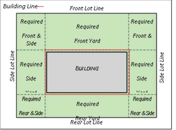
3
multi-unit residential building, in accordance with applicable building
restriction lines, covenants, plat notations, and setbacks, if any.
*Buildable Area Graphic
SECTION 2.05 - COASTAL AREAS
“Coastal Areas” means areas which border on bays or estuaries or other
waterways subject to tidal action which are subject to possible flooding or
increased flood levels because of tidal action, hurricane surge or rising water
due to storms, hurricanes or tsunamis. A “coastal area” is not necessarily in a
“V” Zone. In cases where there is a question as to whether an area is a coastal
area, the Harris County Engineering Department shall refer to the FEMA Flood
Insurance Study.
SECTION 2.06 - CONDUIT
A “Conduit” is any open or closed device for conveying flowing water.
4
SECTION 2.07 - COUNTY ENGINEER
“County Engineer” means the holder of the statutory position of the County
Engineer for Harris County or the employee designated by the County Engineer
to perform a task required by these Regulations.
SECTION 2.08 - CURB AND GUTTER SECTIONS
A “Curb and Gutter Section” is a full width concrete pavement with curb, either
doweled on six-inch (6”) curbs or doweled four-inch (4”) by twelve-inch (12”)
curb or monolithic curb and gutter sections for asphalt concrete pavement.
SECTION 2.09 - DESIGN STORM EVENT
“Design Storm Event” means the rainfall intensity upon which the drainage
facility will be sized. References to rainfall conditions in these specifications
shall apply to “Technical Paper No. 40, U. S. Weather Bureau”, published by the
U. S. Department of Agriculture, Soil Conservation Service.
SECTION 2.10 - DRAINAGE AREA MAP
“Drainage Area Map” means the area map of a watershed, which is subdivided
to show the area served by each subsystem.
SECTION 2.11 - ELEVATION
“Elevation” means height above mean sea level. The North American Vertical
Datum (NAVD) of 1988 (2001 Adjusted) shall be used. Any future studies
changing the Flood Insurance Rate Map (FIRM), which is referenced to a later
re-leveling of the vertical control system shall be used whenever a revised FIRM
becomes effective.
5
SECTION 2.12 - EXTREME EVENT
“Extreme Event” means a rainfall event, which exceeds the Design Storm Event
up-to and including the 100-year frequency resulting in surcharge of the
underground storm sewer system and overland sheet flow.
SECTION 2.13 - FEMA
“FEMA” means the Federal Emergency Management Agency.
SECTION 2.14.a. – FLOODPLAIN EASEMENT
“Floodplain Easement” means the area of a residential lot shown on a final
plat that is within the 100-year floodplain as determined by the current Flood
Insurance Rate Map (FIRM). The Floodplain Easement will provide notice that
the residential lot is subject to special development and permitting
requirements by local governments implementing flood hazard area
regulations as part of a flood management program developed in compliance
with the National Flood Insurance Program or Texas Water Code Section
16.315. The Floodplain Easement encumbers that portion of a “residential lot”
that may be used for residential purposes which may be flood prone or in a
flood hazard area based on the current FIRM. Improvements constructed or
placed in a Floodplain Easement, including single-family and multi-family
dwelling units, may be subject to additional floodplain management
regulations.”
SECTION 2.14 - GEOTECHNICAL ENGINEER
A “Geotechnical Engineer” is a licensed engineer within the State of Texas who
works for a company registered in the State of Texas that has been accredited
by the American Association for Laboratory Accreditation (A2LA) in
geotechnical testing.
SECTION 2.15 - HCFCD
“HCFCD” means the Harris County Flood Control District.
6
SECTION 2.16 - HYDRAULIC GRADE LINE
“Hydraulic Grade Line” means the line representing the pressure head available
at any given point within the drainage system.
SECTION 2.17 - IN-FILL DEVELOPMENT
“In-fill Development” means the development of open tracts of land in areas
where the storm drainage infrastructure is already in place and takes
advantage of the existing infrastructure as a drainage outlet.
SECTION 2.18– LATENT DEFECTS
“Latent Defects” means a defect or condition of construction which does not
comply with the construction documents or designs intent which is generally a
hidden or concealed defect which cannot be discovered by reasonable or
customary inspection, examination or observation at either the time of
construction or substantial completion, but which manifests over time.
SECTION 2.19 – LOT
For the purpose of these regulations the term Lot means any platted lot, parcel,
or reserve.
SECTION 2.20 - MEAN SEA LEVEL
“Mean Sea Level” means the average height of the surface of the sea for all
states of the tide as was established by the United States Coastal and Geodetic
Survey in 1929.
SECTION 2.21 - PERSON
“Person” includes any individual or group of individuals, corporation,
partnership, association, or any other organized group of persons, including
State and Local governments and agencies thereof.
7
SECTION 2.22 - RAINFALL FREQUENCY
“Rainfall Frequency” means the probability of a rainfall event of defined
characteristics occurring in any given year. Information on rainfall frequency
is published by the National Weather Service. For the purpose of storm
drainage design, the following frequencies are applicable:
1. 2-year frequency – a rainfall intensity having a 50% probability of
occurrence in any given year, or nominally likely to occur once every two
years.
2. 3-year frequency – a rainfall intensity having a 33% probability of
occurrence in any given year, or nominally likely to occur once every
three years.
3. 5-year frequency – a rainfall intensity having a 20% probability of
occurrence in any given year, or nominally likely to occur once every five
years.
4. 10-year frequency – a rainfall intensity having a 10% probability of
occurrence in any given year, or nominally likely to occur once every ten
years.
5. 25-year frequency – a rainfall intensity having a 4% probability of
occurrence in any given year, or nominally likely to occur once every
twenty-five years.
6. 100-year frequency – a rainfall intensity having a 1% probability of
occurrence in any given year, or nominally likely to occur once every one
hundred years.
7. 500-year frequency – a rainfall intensity having a 0.2% probability of
occurrence in any given year, or nominally likely to occur once every five
hundred years.
SECTION 2.23 - REDEVELOPMENT
“Redevelopment” means a change in land use that alters the impervious cover
from one type of development to either the same type or another type and takes
advantage of the existing infrastructure in place as a drainage outlet.
8
Section 2.24 - RESIDENTIAL LOT
“Residential lot” means a lot, parcel or reserve within a subdivision on which
a single-family dwelling unit or a multi-family residential structure may be
lawfully constructed, located or placed, including a site built home, modular
home, manufactured home, townhouse, duplex or a multi-unit residential
building.
SECTION 2.25 - ROADSIDE DITCH SECTIONS
“Roadside Ditch Sections” are ditch sections adjacent to either full width
reinforced concrete pavement or asphaltic concrete pavement.
SECTION 2.26 - SHEET FLOW
“Sheet Flow” means the overland storm runoff that is not conveyed in a defined
conduit and is typically in excess of the capacity of the conduit or roadside
ditch.
SECTION 2.27 - SUBDIVISION
“Subdivision” means a division of any tract of land into two (2) or more parts
for the purpose of laying out any subdivision or any tract of land or any addition
to the city, or for laying out suburban lots or buildings lots, or any lots, and
streets, alleys or parts of other portions intended for public use or the use of
the purchasers or owners of lots fronting thereon or adjacent thereto. A
subdivision includes re-subdivision (replat), but it does not include the division
of land in parcels or tracts of ten (10) acres or more and not involving any new
streets, alleys or easements of access. This definition is based on current state
statutes and should the statutes be changed its new definition would govern.
SECTION 2.28 –SUBSTANTIAL MODIFICATION
Substantial modification shall mean changes to the approved plans, plat, and/or
drainage report or change of use that will increase impervious cover, or the
volume and/or peak discharge of the stormwater runoff from portions of, or
the whole of the project or any other change that would affect the volume or
peak discharge of stormwater runoff that would cause adverse impacts to off-
site properties.
9
SECTION 2.29 - UNINCORPORATED AREA
“Unincorporated Area” means the area in Harris County, Texas, which is not
within an incorporated area of a city, town, and village or within the
“jurisdiction of the Port of Houston Authority of Harris County, Texas,” being
that area within 2,500 feet of the thread of the Houston Ship Channel that is
eligible for limited purpose annexation pursuant to Texas Local Government
Code §43.136.
10
SECTION 3 - GENERAL PROVISIONS
SECTION 3.01 - ADMINISTRATION BY THE COUNTY ENGINEER
The County Engineer is responsible for the administration of these Regulations,
approval of plans required by these Regulations, and enforcement of these
Regulations and maintaining proper records. The County Engineer may
delegate particular authority given to the County Engineer under these
Regulations to another member of the Harris County Engineering Department
and an action by such delegated person under such granted authority shall be
deemed an action of the County Engineer.
SECTION 3.02 - RESPONSIBILITY OF OTHER OFFICIALS
Under these regulations the Harris County Engineering Department is
responsible for all administrative decisions, determinations and duties. The
Harris County Engineering Department may seek and secure the assistance of
other officials of Harris County and of the Harris County Flood Control District
in making its decisions, determinations and in performing duties but is not
required to conform to the recommendations of others.
11
SECTION 4 - ADMINISTRATIVE PROCEDURES
FOR THE REVIEW OF PLATS
SECTION 4.01 - APPROVAL REQUIRED
All development within the unincorporated areas of Harris County is prohibited
without first securing approved plans or plat, if required, and a development
permit issued under the Regulations of Harris County, Texas, for Floodplain
Management.
SECTION 4.02 - ENFORCEMENT
It shall be unlawful for any person to lay out, subdivide or plat any land into
lots, blocks, tracts or streets within the unincorporated area of Harris County
if the land has not been laid out, subdivided and platted in accordance with
these rules and regulations.
SECTION 4.03 - PLAT CRITERIA
For tracts of land located within the extraterritorial jurisdiction (ETJ) of an
incorporated city or town and subject to the jurisdiction of the Planning
Commission or other governing body of that city or town, general
subdivision and layout requirements as established by the applicable
Commission or other governing body shall apply. In the circumstance where
any rule, regulation, procedure or policy lawfully or officially adopted by the
governing body of any city or town exercising jurisdiction within its
extraterritorial jurisdiction is less restrictive than that contained herein, the
standards adopted by these rules and regulations and applicable State law
shall apply.
For all other tracts not located within a municipality’s extraterritorial
jurisdiction or for which the municipality has issued a written certification
stating that a plat is not required to be filed for that subdivision of land in
accordance with Chapter 212 of the Texas Local Government Code, the
following rules and design requirements shall apply:
1. Lots shall be of sufficient acreage to meet minimum requirements for
on-site sewage service per TCEQ Chapter 285.4 Facility Planning
regulations, unless served by public water and/or sewage.
12
2. Public road rights-of-way shall be a minimum fifty feet (50’) in width
and in conformance with the Geometric Design Guidelines as adopted
by Harris County Commissioners’ Court.
3. A building setback line of not less than twenty-five feet (25’) from the
road right-of-way shall be imposed on tracts intended for construction
of a single-family structure or structures. However, twenty-foot (20’)
building setback lines will be permitted for single-family residential
lots on cul-de-sacs and knuckles. A ten-foot (10’) building setback line
will be permitted on side lots of single-family residential lots. A
building setback line of no less than ten feet (10’) shall be imposed on
all other tracts. These setbacks may be modified if such modifications
comply with County Planning Criteria.
4. Construction of road and appurtenant drainage facilities shall be in
conformance with specifications as set out in these rules and
regulations.
5. Surveyor shall delineate the limits of the 100-year floodplain on a final
plat and designate a Floodplain Easement on that portion of all
residential lots where the buildable area is within the 100-year
floodplain.
6. Financial Surety: A cash deposit, bond, or letter of credit made in
accordance with the Texas Local Government Code 232.004 or
232.0045 and these regulations.
For all tracts not located within a municipality’s extraterritorial jurisdiction,
thoroughfare alignment and right-of-way (ROW) width planning shall follow
the requirements specified in the Thoroughfare Amendment Study for
Unincorporated and Non-ETJ Areas of Harris County, Texas as adopted by
Harris County Commissioners’ Court and any subsequent revisions thereto.
SECTION 4.04 - EXCEPTIONS
Exceptions to platting requirements are established in Section 232.0015 of
the Texas Local Government Code. A brief description follows:
1. A county may not require the owner of a tract of land located outside
the limits of a municipality who divides the tract into two or more parts
to have a plat of the subdivision prepared if the owner does not lay out
a part of the tract as streets, alleys, squares, parks, or other parts of the
13
tract to be dedicated to public use or for use of lots fronting on or
adjacent to the streets, alleys, squares, or other parts, and the land is
to be used primarily for agricultural use or farm, ranch, wildlife
management, or timber production.
2. A county may not require the owner of a tract of land located outside
the limits of a municipality who divides the tract of land into four or
fewer parts and does not lay out a part of the tract as streets, alleys,
squares, parks, or other parts of the tract to be dedicated to public use
or for use of lots fronting on or adjacent to the streets, alleys, squares,
or other parts to have a plat of the subdivision prepared if each of the
lots is to be sold, given, or otherwise transferred to an individual who
is related to the owner within the third degree by consanguinity or
affinity per Chapter 573, Government Code. If the tract is transferred
to another who is not related within the third degree by consanguinity
or affinity, then the platting requirements of these regulation shall
apply.
3. A county may not require the owner of a tract of land located outside
the limits of a municipality who divides the tract into two or more parts
to have a plat of the subdivision prepared if all the lots of the
subdivision are more than 10 acres in area and the owner does not lay
out a part of the tract as streets, alleys, squares, parks, or other parts
of the tract to be dedicated to public use or for use of lots fronting on
or adjacent to the streets, alleys, squares, or other parts.
4. A county may not require the owner of a tract of land located outside a
municipality to have a plat of the subdivision prepared if all the lots are
sold to veterans through the Veterans’ Land Board program.
5. A county may not require the owner of a tract land to have a plat
prepared if the owner is the state or any state agency, board, or
commission or owned by the permanent school funds of the state unless
the subdivision lays out a part of the tract as streets, alleys, squares,
parks, or other parts of the tract to be dedicated to public use or for use
of lots fronting on or adjacent to the streets, alleys, squares, or other
parts.
6. A county may not require the owner of a tract of land located outside
the limits of a municipality who divides the tract into two or more parts
to have a plat of the subdivision prepared if the owner of the land is a
political subdivision of the state, the land is situated in the floodplain,
and the lots are sold to adjoining landowners.

14
7. A county may not require the owner of a tract of land outside the limits
of a municipality who divides the tract into two parts to have a plat of
the subdivision prepared if the owner does not lay out a part as streets,
alleys, squares, parks, or other parts of the tract to be dedicated to
public use or for use of lots fronting on or adjacent to the streets, alleys,
squares, or other parts and one part is to be retained by the owner, and
the other new part is to be transferred to another person who will
further subdivide the tract subject to the plat approval requirements.
8. A county may not require the owner of a tract of land located outside
the limits of a municipality who divides the tract into two or more parts
to have a plat of the subdivision prepared if the owner does not lay out
a part of the tract as streets, alleys, squares, parks, or other parts of the
tract to be dedicated to public use or for use of lots fronting on or
adjacent to the streets, alleys, squares, or other parts and all parts are
transferred to persons who owned an undivided interest in the original
tract and a plat is filed before any further development of any part of
the tract.
SECTION 4.05 - REVIEW PROCEDURES
Municipalities in Harris County exercising their extraterritorial jurisdiction
(“ETJ”) in the unincorporated area of Harris County have developed specific
and unique procedures in processing plats. The procedures outlined below
shall be followed for submitting a plat application and plat to a municipality
and Harris County for review and comment. Procedures for submitting a plat
application and plat for property located in the unincorporated area of Harris
County are also included below. For all plats within a municipality’s ETJ, use
the dedicatory language as promulgated by that municipality. For plats not
located in a municipality’s ETJ, required dedicatory language and all plat
certificate requirements are set forth in Section 4.07 and in Appendix “A”
respectively.
Plats Within A Municipality’s ETJ. For plats of property located in the
unincorporated area of Harris County and the ETJ of a municipality, the
owner of the tract being platted shall submit copies of the plat, along with a
plat application, to the municipality exercising ETJ for review and comments,
at which time the municipality may begin its review of the plat. It shall be
the responsibility of the owner of the tract being platted to ensure that the

15
Harris County Engineering Department and the Harris County Flood Control
District also receive copies of the plat.
Plats Not Located in a Municipality’s Extraterritorial Jurisdiction. For plats
of property located exclusively in the unincorporated area of Harris County
and not in the extraterritorial jurisdiction of any municipality, the owner of
the tract being platted shall simultaneously submit copies of the plat
application and the plat to the Harris County Engineering Department and the
Harris County Flood Control District, at which time they will begin their
review of the plat.
All Plats. Upon Harris County Engineering Department’s receipt of the
original mylar of the plat fully executed by the owners and, as applicable,
approved by the appropriate Planning Commission or governing body, along
with the required documentation described in “Recordation Requirements” in
Section 4.06 below, Harris County Engineering Department will begin its
review of the plat.
If the plat does not meet all the requirements of Section 4 of these
Regulations, the Harris County Engineering Department will provide its
comments to the owner of the tract being platted in accordance with Section
232.0025 of the Texas Local Government Code. If the plat meets all the
requirements set forth in Section 4 of these Regulations, the Harris County
Engineer will sign it. The plat will then be placed on the next available
Commissioners’ Court agenda for approval.
Once approved by Harris County Commissioners Court (“Court”), the Court
will send the plat to the office of the Harris County Clerk for recordation. The
Harris County Clerk shall calculate the required recording fees and notify the
applicant or applicant’s designee of same. Upon receipt of such fees, the plat
will be filed and recorded in the Official Public Records of Real Property and
Map Records of Harris County, Texas.
SECTION 4.06 - RECORDATION REQUIREMENTS
The following documentation is required to be submitted along with the
original mylar of the plat that is to be reviewed by the Harris County
Engineering Department, submitted to Harris County Commissioners’ Court
for approval, and filed with the Harris County Clerk. Harris County will
accept for recordation only those plats printed on the front side of the mylar
or other reproducible material.
16
1. A title report, or opinion, title policy or certificate or letter from a title
company authorized to do business in the State of Texas must be
provided indicating ownership of the property, all liens against same,
and any existing easements. The title report shall not have been
executed more than sixty (60) days prior to the time the final plat is
received by the Harris County Engineering Department and may
require updating at the request of Harris County personnel. Owners of
property located within the plat must either sign the plat or execute an
Owner’s Ratification of Plat document, as promulgated by the County
Engineer. Furthermore, liens against the property shall be subordinate
to all dedication of streets, rights-of-ways, easements and terms and
conditions referred to on the plat. Lienholders must either sign the plat
or execute a Lienholder’s Subordination to Dedication document as
promulgated by the Harris County Engineer. See Appendix “B” for
notary formats.
2. An original tax certificate from the tax collector of each political
subdivision in which the property is located showing that all taxes
owed to the County, School District, Utility District, and/or any other
political subdivision have been paid in full. If the plat or replat is filed
after September 1 of a year, the plat or replat must also have attached
to it a tax receipt issued by the collector for each taxing unit with
jurisdiction of the property indicating that the taxes imposed by the
taxing unit for the current year have been paid or, if the taxes for the
current year have not been calculated, a statement from the collector
for the taxing unit indicating that the taxes to be imposed by that taxing
unit for the current year have not been calculated. If the tax certificate
for a taxing unit does not cover the preceding year, the plat or replat
must also have attached to it a tax receipt issued by the collector for
the taxing unit indicating that the taxes imposed by the taxing unit for
the preceding year have been paid in full.
This requirement does not apply to the extent of the applicability of
exceptions in Texas Property Code 12.002(e) in regard to certain real
property acquired by will or inheritance or to certain property acquired
by eminent domain.
3. A completed Utility Service Plan, as promulgated by the County
Engineer, shall be submitted. In no case shall a plat be recorded prior
to assurances being given that all applicable State and County reviews
and/or permit(s) have been obtained.
17
4. A letter from the County Tax Assessor-Collector certifying that the
name of the subdivision to be presented to Commissioners’ Court is not
in conflict with any other previously recorded subdivision. This
requirement applies to the first section of multi-section subdivisions,
all re-plats, and amending plats and is not applicable to street
dedication plats designated by a street name.
5. Approved plans are to be on file with the Engineering Department at the
time the plat is submitted to Commissioners’ Court. However, if the
tract of land is being platted to create reserves for the purpose of sale
only and there are no immediate plans for construction of
improvements on said reserves, then a note shall be placed on the face
of the plat stating:
“Site drainage plans for the future development of this reserve must
be submitted to the Harris County Flood Control District and the
Harris County Engineering Department.”
6. A letter, statement or other instrument from the owner of any privately
owned easement within the plat boundaries where such easement is to
be crossed by streets (either public or private) or public utility or
drainage easements, stating that the owner of such easement approves
such crossing of the private easement for the purposes intended and
depicted on the plat, if such approval is not granted in the original
document conveying the easement.
7. A plat review fee as established by Commissioners’ Court is required
to be submitted.
8. For plats of lots and/or reserves requiring plan review and not
dedicating any public rights-of-way, a non-refundable administrative
fee is assessed in the amount of $10.00 per lot. Reserves are assessed
a non-refundable administrative fee of $20.00 per 100 feet of plat
boundary adjoining road right-of-way rounded to the next highest
increment of $20.00. Payment of administrative fees should be made
payable to Harris County and are due prior to the plat being promoted
to Commissioners’ Court for action. Payment of administrative fees
must be submitted with the Financial Surety/Administrative Worksheet
validated by the Planning Section.

18
9. For plats proposing the dedication of a public street(s) and construction
of paving and appurtenant drainage, a Financial Surety is required prior
to plat approval and shall be:
A. Made payable to Harris County, unless cash; and
B. In a total amount based upon the following schedule:
RESIDENTIAL SUBDIVISIONS COMMERCIAL AND STREET
DEDICATION SUBDIVISIONS
$50 per lot with average road
frontage less than 100 feet.
$75 per 100 feet of proposed
pavement. The fee shall be
rounded to the next 100 feet.
$75 per lot with average road
frontage 100 feet or greater.
* NOTE:
The minimum financial surety posted in any case shall be $2,500.00.
Included is the non-refundable administrative fee of $10 per lot for
residential subdivisions or $20 per 100 ft. of pavement in commercial
and street dedication subdivisions.
10. For properties being platted in the unincorporated areas of Harris
County, where there is not Extraterritorial Jurisdiction being exercised
for water and sewer facilities, the following requirements for water and
sewage facilities apply:
A. The drinking water supply shall meet the minimum requirements
established by Chapter 341 of the Health and Safety Code and any
other minimum requirements established by the Texas
Commission on Environmental Quality applicable to drinking
water.
B. Any onsite sewerage disposal systems shall be constructed in
accordance with Chapter 366 of the Health and Safety Code and
the Revised Rules of Harris County for On-Site Sewerage
Facilities.
19
C. Any sewerage facility other than a properly permitted onsite
sewage facility shall be constructed and operated under a valid
permit issued by the Texas Commission on Environmental
Quality.
11. If a property lies within the 100-year floodplain as shown on the most
recent FIRM adopted by Harris County, the floodplain must be
delineated graphically on the final plat. Surveyor shall designate a
Floodplain Easement on that portion of all residential lots where the
buildable area of those residential lots is within the 100-year
floodplain. Refer to Section 4.08 for floodplain easement dedicatory
language.
12. Additional information may be required by the Engineering Department
to clarify or support any of the aforementioned recordation
requirements.
SECTION 4.07 – FLOODPLAIN EASEMENTS ON PLATS
Where the buildable area of a lot, parcel or reserve is intended for
single family or multi-family residential units and is proposed to be placed
within the mapped 100-year floodplain, the final plat shall show that portion
of the 100-year floodplain as a “Floodplain Easement” on the plat. The
Floodplain Easement shall be illustrated on the final plat map as congruent
with the limits of the 100-year floodplain within the plat boundary from the
most recent FIRM and shall be included as a dedication by the property owner
using the language below.
1) Sample Floodplain Easement
”A Floodplain Easement is hereby established over that portion of the
effective 100-year floodplain area as delineated from FIRM PANEL No.
XXXX dated XXXX within the boundary of this final plat, the limits of
which impact the buildable areas of residential lots, wholly or partially,
and within such area is prone to flooding. (*See attached sketch.)
Construction of any type of residential housing within a Floodplain
Easement is subject to additional flood hazard area regulations. A
Floodplain Easement may be abandoned by Harris County
Commissioners Court if the buildable area of a residential lot is
determined to be outside the 100-year floodplain by submitting County
Engineer’s Form 1226, with the applicable documentation and fee, to
the Office of the County Engineer.

20
2) Abandonment of Floodplain Easement
A Floodplain Easement may be abandoned by using following
procedure:
a) Complete Harris County Engineer Form 1226 including providing proof
that the buildable area of a specific residential lot(s) has been removed
from the mapped 100-year floodplain by a letter of map revision
(LOMR) or a letter of map amendment (LOMA).
b) Submit the applicable fee, to be the same as a permit for a single family
residence outside the floodplain, currently $75.00.
c) Once received, reviewed and approved by the Office of the County
Engineer, a Court Order will be submitted to Commissioners Court,
abandoning the Floodplain Easement on the residential lot(s).
d) Once approved by Commissioners Court the County Engineer will file
the abandonment in the Real Property Records of Harris County.
SECTION 4.08 - DEDICATORY LANGUAGE AND CERTIFICATES REQUIRED
ON PLATS OF PROPERTY LOCATED IN THE
UNINCORPORATED AREA OF HARRIS COUNTY
1. Dedicatory language on the plats must include the following paragraphs
and can be found in Appendix “A” to these regulations:
A. “FURTHER, Owners do hereby dedicate to the public a strip of
land fifteen (15) feet wide on each side of the center line of any
and all bayous, creeks, gullies, ravines, draws, sloughs, or other
natural drainage courses located in said plat, as easements for
drainage purposes, giving the City of (name of city), Harris
County, or any other governmental agency, the right to enter
upon said easement at any and all times for the purpose of
construction and maintenance of drainage facilities and
structures.”;
B. “FURTHER, Owners do hereby covenant and agree that all of the
property within the boundaries of this plat and adjacent to any
drainage easement, ditch, gully, creek or natural drainage ways
shall hereby be restricted to keep such drainage ways and
21
easements clear of fences, buildings, planting and other
obstructions to the operations and maintenance of the drainage
facility and that such abutting property shall not be permitted to
drain directly into this easement except by means of an approved
drainage structure.”; and
C. “FURTHER, Owners certify and covenant that they have complied
with or will comply with existing Harris County Road Law,
Section 31-C as amended by Chapter 614, Acts of 1973, 63
rd
Legislature and all other regulations heretofore on file with the
Harris County Engineer and adopted by the Commissioners’ Court
of Harris County.”
2. Additional certification on the plat must indicate the floodplain status
of the buildable areas on “residential lots” on the plat, referring to the
applicable Flood Insurance Rate Map panel and effective date.
A. Buildable Areas Outside the Floodplain:
“I, ___________________, a Registered Professional Licensed
Surveyor in the State of Texas, do hereby certify that the buildable
areas for all residential lots are outside [or, are proposed to be
outside, based on engineering plans and specifications submitted to
the County Engineers Office,] the 100-Year Floodplain as shown on
Federal Insurance Rate Map Panel No. [insert panel number] dated
[insert effective date of map]. This certification is based solely on
plotting boundaries from the FIRM Map, and no technical analysis
was conducted.”
B. Buildable Areas in the Floodplain
“I, ____________________ a Registered Professional Licensed
Surveyor in the State of Texas, do hereby certify that the buildable
areas for all or some of the residential lots are located within the
100-year floodplain as plotted from the Federal Insurance Rate Map
Panel No. [insert panel number] dated [insert effective date of map]
and are subject to flooding. The 100-year floodplain is a flood hazard
area prone to flooding, and subject to additional floodplain
management regulations.”
3. Floodplain easement dedicatory language must be shown on the plat if
a Floodplain Easement is required in accordance with Section 4.07 Floodplain
Easements.
22
”A Floodplain Easement is hereby established over that portion of
the effective 100-year floodplain area as delineated from FIRM
PANEL No. XXXX dated XXXX within the boundary of this final plat,
the limits of which impact the buildable areas of residential lots,
wholly or partially, and within such area is prone to flooding. (*See
attached sketch.) Construction of any type of residential housing
within a Floodplain Easement is subject to additional flood hazard
area regulations. A Floodplain Easement may be abandoned by
Harris County Commissioners Court if the buildable area of a
residential lot is determined to be outside the 100-year floodplain
by submitting County Engineer’s Form 1226, with the applicable
documentation and fee, to the Office of the County Engineer.
4. Approved Certificate Language may be found in Appendix “A” to these
regulations.
SECTION 4.09 – Alternative Planning Criteria
Harris County Alternate Planning Criteria for Subdivisions and Platting shall be
adhered to when more stringent than municipality whose extraterritorial
jurisdiction includes any part of unincorporated Harris County. Chapter 42-
Section 3 of the City of Houston’s Ordinance codifies this requirement;
however, the County Planning Criteria applies to all city’s ETJ areas.
Projects following the below County Planning Criteria, are deemed to be more
stringent and said criteria supersedes criteria of any City’s ETJ requirement. To
prevent confusion, any plat using the County’s more stringent criteria, will be
reviewed by the County first, and if found to meet the County Criteria, a letter
will be issued by the County Engineer stating that fact for use by the respective
City.
23
County Planning Criteria
(These pages left intentionally blank)
24
SECTION 5 - ADMINISTRATIVE PROCEDURES FOR THE
REVIEW OF CONSTRUCTION PLANS
SECTION 5.01 - SUBMITTAL PROCEDURES
1. A preliminary set of plans shall be submitted to the County Engineer for
review along with a County issued Routing Slip. Upon review, the Plans
will be returned to the consultant with any necessary comments. Plans
may be reviewed electronically by submitting through the online
system using the appropriate application.
2. Upon addressing all the comments, a final review will be conducted by
submitting the marked-up preliminary set, a reproducible set, and the
routing slip to the County Engineer. The plans will be approved or
additional comments will be made and the sets returned.
SECTION 5.02 - CONSTRUCTION PLANS - GENERAL
For all construction plans submitted to the Harris County Engineering
Department pursuant to these regulations, the following requirements shall
apply:
1. A Professional Engineer, licensed in the State of Texas, is required to
seal, date and sign each sheet of the plans in accordance with rules set
forth by the Texas State Board for Professional Engineers. The seal must
reproduce on all sheets.
2. A cover sheet shall be required for all projects involving three or more
plan and profile sheets. All plan sheet numbers should be included on
the cover sheet or area map. A vicinity map should always be included
to show the project location.
3. Plans for street and/or public improvements shall be standard twenty-
two inch by thirty-four inch (22” x 34”) overall dimensions for all
design in rights-of-way or easements. Site plans may be submitted on
larger sheets when practical.
4. Plans submitted for Harris County Engineering Department approval
shall be on a reproducible material.
25
5. A North arrow is required on all sheets and should be generally oriented
either upward or to the right.
6. All projects shall be tied to the datum adjustment that matches the
FIRMs or the most current datum available in coastal areas. Equations
may be used to translate other datum adjustments to the required
adjustment.
7. Graphic standards for construction plans submitted shall be in
accordance with those outlined in Appendix “C” to these regulations.
8. If the property lies below the base flood level, the floodplain must be
delineated graphically on all plan sheets.
SECTION 5.03 - PLAN LAYOUT REQUIREMENTS
Plans submitted to the Harris County Engineering Department pursuant to
these regulations shall have the following items:
1. General construction layouts shall be submitted for all paving and
utility projects involving more than three plan and profile sheets. For
the purpose of fulfilling this requirement, paving and drainage layouts
may be combined and water and sanitary sewer layouts may be
combined.
2. A drainage area map shall be submitted and shall include drainage
computations with drainage area and storm water flow labeled.
3. A lot grading plan shall be submitted for residential lots on which
earthwork is proposed that will change the natural topography.
4. A drawing showing existing natural contours at one-foot (1’) intervals
of the land to be developed.
5. A graphical sheet index shall be included on the general construction
layout or on a separate index sheet showing the plan and profile sheet
location and sheet number.
6. Match lines in appropriate locations and not in the intersections of two
streets or cul-de-sac knuckles shall be provided.
7. If a roadway exists where plans are being prepared to improve the
26
roadway or construct new pavement or to construct a utility, this
roadway should be labeled as to its existing width, type of surfacing and
base thickness if available without destruction of pavement.
8. All improvements shall be labeled as “Proposed” or “Existing” in both
Plan and Profile Views.
9. Include a fire lane designed in accordance with the current Harris
County Fire Code for approval with all commercial site plans.
10. Include a landscape plan designed in accordance with these regulations
for approval with all commercial site plans.
SECTION 5.04 - STANDARD DETAIL SHEETS
For all construction plans submitted to the Harris County Engineering
Department pursuant to these regulations, the following requirements shall
apply:
1. The Harris County standard paving and detail sheets shall be
incorporated by reference in the project specifications and by
construction notes on the plans.
2. The details of special structures not covered by approved standard
drawings, such as stream and gully crossings, special manholes, etc.,
should be included. The details shall be drawn on the detail sheets with
the horizontal and vertical scales equal.
3. The Harris County Engineering “Express Review Sheet” shall be
submitted with each set of plans and be completed including Harris
County Appraisal District account number.
SECTION 5.05 - STANDARD NOTE REQUIREMENTS
The following standard notes shall be included in the plans, where applicable,
as specified below:
1. All projects shall include the notes in Appendix “D” to these regulations.
2. All projects involving paving or utilities located in a public right-of-way
27
shall include notes in Appendix “E” to these regulations.
3. All projects involving esplanade openings and turn lanes shall include
the notes in Appendix “F” to these regulations.
4. All projects located within the 10% (10-year) floodplain, the 1% (100-
year) floodplain, or the 0.2% (500-year) floodplain shall include notes
in Appendix “G” to these regulations.
SECTION 5.06 – SUPPLEMENTAL REQUIREMENTS
Unless otherwise directed by the County Engineer, the following additional
requirements shall be included with the initial submittal of preliminary plans
or prior to final plan approval as set forth below:
1. Harris County Flood Control District approval is required prior to final
plan approval.
2. Harris County Toll Road Authority approval is required prior to final
plan approval if project encroaches or impact HCTRA right-of-way.
3. Texas Department of Transportation (TxDOT) approval is required
prior to final plan approval if project encroaches or impacts HCTRA
right-of-way.
4. If required, Traffic Impact Analysis approval is required prior to final
plan approval.
5. If project encroaches into a pipeline easement, approval from the
owner of the easement is required prior to final plan approval.
6. If utility connections are proposed, approval from the utility owner
verifying capacity is required prior to final plan approval.
7. If project encroaches into jurisdictional wetlands, approval from the
U.S. Army Corps of Engineers if required prior to final plan approval.
8. Maintenance Agreements for non-standard items located in Harris
County right-of-way are required prior to final plan approval.
28
9. Harris County Capital Improvement Projects Division Interpose “No
Objection” letter for projects adjacent or affecting capital projects are
required prior to final plan approval.

29
SECTION 6 - DRAINAGE REQUIREMENTS
SECTION 6.01 - DRAINAGE POLICY
1. Design Requirements
A. The drainage criteria administered by Harris County and
complemented by the City of Houston and the Harris County Flood
Control District Criteria for newly designed areas provides street
drainage design at a 2-year event frequency, and protects from
structural flooding at the 100-year design frequency. Additionally,
in areas in or adjacent to mapped floodplains, structural protection
is provided for the 500-year design event, using those elevations
derived from the effective Flood Insurance Study (FIS). This is
accomplished with the application of various drainage
enhancements such as storm sewers, roadside ditches, open
channels, detention and overland (sheet) run-off.
B. Recognizing that each site has unique characteristics that may
enhance the opportunity to provide proper drainage, the intent of
these criteria is to specify minimum requirements. These
minimums may be modified with prior consent of the Harris
County Engineering Department provided that the objective for the
minimum drainage standards is maintained.
2. Street Drainage Design - Street ponding of short duration is anticipated
and designed to contribute to the overall drainage capability of the system.
Storm sewers and roadside ditch conduits are designed as a balance of
capacity and economics. These conduits are designed to convey less
intense, more frequent rainfalls while attempting to allow traffic movement
during these events. When rainfall events exceed the capacity of the storm
sewer system, the additional run- off is intended to be stored or conveyed
overland in a manner that reduces the threat of flooding to structures.
3. Flood Control Design – Harris County is a participant in the National
Flood Insurance Program. The flood insurance program attempts to
make flood insurance available at low cost by providing for measures that
reduce the likelihood of structural flooding.
4. Relationship to the Platting Process – The approval of storm drainage
systems, detention facilities, and flood channel improvements is a part of
the review process for planning and platting of new development.
30
SECTION 6.02 - DESIGN REQUIREMENTS
All designs of major thoroughfare drainage facilities, manholes, inlets, bedding
and backfill shall meet the requirements of Standard Specifications, Standard
Drawings and Harris County Regulations.
The Standard Specifications, Standard Drawings, Harris County Regulations, as
well as the most recently adopted City of Houston design guidelines, will apply
for all non-major thoroughfare projects located within Harris County and the
City of Houston ETJ. The most stringent design details shall apply in the event
of any discrepancy.
Note: With prior approval, products listed in the Harris County Special
Specifications 8013 may be used. Alternative types of pipe proposed for use in
storm sewer applications must receive prior approval of the County Engineer.
1. Method of Determining Runoff
A. Area runoff shall be determined using the Rational Formula which
is defined as:
Q = CiA
Where Q = amount of runoff in cubic feet per second (cfs)
C = watershed imperviousness coefficient. See
Figure 1: Minimum “C” Values for Land Use
Types for suggested typical values.
i = rainfall intensity in inches per hour
Implicit in the determination of “i” is when the entire
watershed under consideration is contributing runoff, a
concept known as the Time-of Concentration (T
c
) ratio,
which are expressed in minutes.
T
c
represents the time in minutes required for the runoff to
flow through the drainage area to the point of consideration.
This is defined as:
T
c
=
10 A
0.1761
+ 15 (in minutes)

31
A = acres of subarea under consideration in the
watershed area
Note: See Appendix “H” for intensity duration
B. Design Storm Events for typical storm sewer design will consist of
a 2-year storm. Unless otherwise directed by the County Engineer,
design rainfall pattern shall follow the requirements specified in
the most recently amended HCFCD Criteria Manual. Rainfall
intensity for storm sewer design must be determined using Region
3 data (Appendix H) for all regions of unincorporated Harris
County.
Figure 1: Minimum “C” Values for Land Use Types
Land Use Type
Runoff
Coefficient
Residential Districts
Lots more than ¾ acres 0.35
Lots ¼ - ¾ acre 0.45
Lot less than ¼ acre 0.55
Multi-Family Areas
Less than 20 DU/AC 0.65
20 DU/AC or Greater 0.80
Business Districts 0.80
Industrial Districts
Light Areas 0.65
Heavy Areas 0.75
Railroad Yard Areas 0.30
Parks / Open Acres 0.18
C. Application of Runoff Calculation Models
(1). The Rational Method shall be used for designs on all areas
served by storm sewer up to 600 acres in size.
(2). Rainfall runoff modeling shall be applied to areas greater
than 600 acres in size or any areas that are drained by an
open channel provided the model takes into account the
32
storage and ponding in streets. Models must be acceptable
to FEMA if they are to support a submittal for a map change.
D. Coefficients for the Rational Method.
(1). The runoff coefficient “C” values in the Rational Method
formula will vary based on the land use. Minimum to be used
is shown in Figure 1: Minimum “C” Values for Land Use
Types.
(2). Alternatively, when the area is not outlined in Figure 1, the
runoff coefficient “C” in the Rational Method formula can be
calculated from the equation:
C = 0.6Ia + 0.2
Where C = Watershed coefficient
Ia = percent impervious area (expressed as a
decimal)
(3). If the alternate form is to be submitted, a calculation of the
computation of C is to be provided as part of the drainage
calculations.
2. Design of Storm Sewers
1. Storm sewers shall be designed using the Manning Equation in
combination with the Continuity Equation. Proper consideration
will be given to the units of measure, whether English or metric.
2. The Manning Equation is defined as:
V = (K/n)R
2/3
S
f
½
Where K = 1.49 for English units
n = 0.013 for concrete pipes and
0.024 for CMP pipes
V = velocity in feet per second
R = hydraulic radius of the conduit in feet
which equals area/wetted perimeter
S
f
= friction slope as headloss per length
33
3. The Continuity Equation is defined as:
Q = VA
Where Q = Discharge or runoff in cubic feet per
second (cfs)
V = velocity in feet per second
A = Cross-sectional area of conduit in square
feet
4. Design Frequency
(1). Newly Developed Areas – The design storm event for sizing
storm sewers in newly developing areas shall be a two (2)
year rainfall.
(2). Redevelopment or In-Fill Development with Increased Rate
of Runoff – The existing storm drain serving redevelopment
or infill development shall be evaluated in accordance with
conditions outlined below, using a 2-year rainfall, assuming
existing development conditions. Afterwards the storm drain
shall be re-evaluated with the proposed re-development, or
in-fill development, in place.
(a). If the hydraulic gradient is twelve inches (12”) or less
above the top of curb with the flow in the receiving
channel at the top of the outfall pipe and no structures
are threatened by the project, then no improvements
to the existing storm drain are required.
(b). If the extreme event analysis indicates that structures
are threatened by flooding, the applicant has the
option of either making improvements to the existing
storm drain or providing detention or improving the
receiving stream and not impacting downstream
conditions.
5. Velocity Considerations
(1). Storm sewers should be constructed to convey the design
flow in sub critical hydraulic conditions if possible.
34
(2). Minimum 2-year flow velocities should not be less than three
feet (3’) per second with the pipe flowing full, under the
design conditions.
(3). Maximum 2-year flow velocities should not exceed eight feet
(8’) per second.
6. Pipe Sizes and Placement
(1). Soil boring with logs shall be made along the alignment of all
storm sewers having a cross section equal to or greater than
seventy-two inches (72”) in diameter or equivalent cross
sectional area. Each boring shall be taken at intervals not to
exceed five hundred (500) linear feet and at a depth of less
than three feet (3’) below the flow line of the sewer. The
required bedding will be determined from the soil boring.
(2). The storm sewer and inlet lead shall be designed with a
minimum of twenty-four inch (24”) inside diameter or
equivalent cross sectional area. Box conduits shall be a
minimum of two feet (2’) by two feet (2’). Closed conduits,
either circular, elliptical, or box, shall be selected based on
hydraulic principles and economy of size and shape.
(3). Larger pipes upstream should not flow into smaller pipes
downstream unless construction constraints prohibit the use
of a larger pipe downstream, or the improvements are
outfalling into an existing system, or the upstream system is
intended for use in detention.
(4). Match crowns of trunk storm sewer pipe at any change in
pipe size unless severe depth constraints prohibit the
matching of crowns. Severe depth constraints include any
system in which the outfall system exists and the designed
storm system cannot achieve 2 feet or more of cover at the
point of lowest cover without additional fill. This includes:
(a). Any system that includes a lake or detention pond, and
the depth of the storm sewers is constrained by that lake
or detention pond, and the designed storm sewer system
cannot achieve 2 feet or more cover at the point of
lowest cover without additional fill.
35
(b). Any time there is a conflict with the existing utility
system which cannot be reasonably relocated. This
includes large diameter water lines, underground
electrical conduits, underground telecommunication
conduits, petrochemical pipelines, or sanitary sewers.
(c). Any time there is a conflict with a proposed sanitary
sewer system which cannot be avoided due to design
criteria constraints. This includes but may not be
limited to sanitary sewers and their service leads.
(d). The saving of specimen trees which would be harmed
by fill on lots with a minimum lot size of 8400 sf. A tree
survey must be provided showing location, size and
species of trees proposed to be saved.
(5). Locate storm sewers in public street rights-of-way or in
approved easements. Proposed storm sewers shall not be
laid parallel to and under proposed or existing pavement.
Parallel storm sewer must be laid at least tw0 feet (2’) from
the back of curb or edge of pavement to the outside edge of
the pipe. Perpendicular roadway crossings are acceptable.
(6). All precast, reinforced, concrete conduits must be laid in a
straight line. Deflection in accordance with manufacturer’s
specifications will be allowed if on approved plans.
(7). All public side lot or back lot drainage facilities shall be
underground storm sewer systems designed in accordance
with these Harris County standards. Drainage swales are
permitted for off-site sheet flow only. Private, individual lot
drainage is exempt from this requirement except when
discharging into a public right-of-way.
(8). In all easements restricted to storm sewers, the conduit shall
be centered within the limits of the easement. The width of
the easement shall be two (2) times the depth plus the
diameter of the pipe rounded up to the next highest five foot
(5’) increment. The minimum shall never be less than twenty
feet (20’).
36
(9). For storm sewers located in easements adjacent to public
street rights-of-way, the minimum width shall be increased
for larger pipe or conduit by requiring that a minimum
distance of five feet (5’) shall be maintained between the
easement line and the outside edge of the sewer, and a
minimum distance of two feet (2’) shall be maintained from
the right-of-way line to the outside edge of the sewer pipe or
conduit.
(10). Do not place the bell of the RCP within an inlet, junction box,
or manhole structure. The bell must be cleanly sawed and
removed prior to placement.
7. Starting Water Surface and Hydraulic Gradient
(1). The hydraulic gradient shall be calculated using the top of
the outfall pipe as the starting water surface elevation.
(2). Should the upstream pipe be higher than the hydraulic grade
line at drop in pipes invert, then the hydraulic grade line shall
be recalculated assuming the starting water surface to be at
the top of the pipe at that point.
(3). For the design storm (a two year frequency), the hydraulic
gradient shall at all times be below the gutter line.
8. Manholes
(1). Use manholes for precast conduits at the following locations:
(a). Size or cross section changes.
(b). Inlet lead and conduit intersections.
(c). Changes in pipe grade.
(d). At a maximum space of seven hundred feet (700’)
along a conduit run.
(2). Use manholes for monolithic concrete storm sewers at the
same locations as precast conduits, except they are not
required at the intersection of inlet leads unless needed to
provide maintenance access.
37
(3). All manholes constructed on proposed or existing major
thoroughfares shall be constructed in accordance with Harris
County Specifications.
(4). All precast manholes must conform to ASTM C 913.
Cored or blocked out pipe openings must be designed to
closely fit the outside diameter of the proposed tie in. Precast
manholes with thin-wall knockouts to accommodate a range
of pipe sizes will not be allowed in the right-of-way.
(5) Incoming and outgoing reinforced concrete pipe must be at
least three inches (3”) away from the corner of the junction
box structure as measured from the outside edge of the pipe
to the inside corner of the structure. If the junction box
structure is pre-cast to accept the corner tie in or the
structure was otherwise designed to accept this, the design
engineer shall submit the design plans and specifications to
Harris County prior to street acceptance.
9. Inlets
(1). Locate inlets at all low points in gutter or at intermediate
points in the profile grade to provide proper drainage.
(2). Inlets should not be placed within driveway locations/limits
but should be placed in the center of the lot.
(3). Valley gutters across intersections are not permitted.
(4). Inlet spacing is a function of gutter slope and should be
designed to conform with the Pavement Design
Requirements and Drainage Design Requirements of these
design guidelines.
(a). Local and collector street section: For minimum gutter
slopes, the maximum inlet spacing shall be a gutter run
of seven hundred feet (700’) at high point in pavement
or the adjacent inlet, with a maximum of one thousand
four hundred feet (1400’) of pavement draining
towards any one inlet location.
(b). On cul-de-sac or partial cul-de-sac sections, gutter runs
shall be limited to four hundred feet (400’).

38
(c). On major thoroughfares, gutter runs shall be limited to
three hundred feet (300’).
(5). Use only Harris County and City of Houston Standard Inlets
shown in Figure 3, “City of Houston Standard Inlets
Acceptable to Harris County.”
(6). Storm sewer leads must be tied directly into the face or back
of “B-B” or “H-2” inlet box and shall not be tied into the short
side of “B-B” or “H-2” inlets.
(7). Do not use “Beehive” grate inlets or other “specialty” inlets.
(8). Do not use unprotected grate-top inlets in unlined roadside
ditch.
(9). Do not place inlets in circular portion of cul-de-sac streets
unless special conditions warrant otherwise and are included
on approved plans and are approved prior to placement.
(10). If drainage will enter or leave proposed pavement then inlets
must be located at the end of proposed pavement.
(11). Do not locate inlets adjacent to median openings.
(12). Place inlets on side streets intersecting major streets, unless
special conditions warrant otherwise and are included on
approved plans.
(13). All precast inlet boxes must conform to ASTM C 913. Cored or
blocked out pipe openings must be designed to closely fit the
outside diameter of the proposed tie in. Precast inlets or
catch basins with thin-wall knockouts to accommodate a
range of pipe sizes will not be allowed in the right-of-way.
(14) Incoming and outgoing reinforced concrete pipe must be at
least three inches (3”) away from the corner of the inlet
structure as measured from the outside edge of the pipe to
the inside corner of the structure. If the inlet structure is
pre-cast to accept the corner tie in or the structure was
otherwise designed to accept this, the design engineer shall

39
submit the design plans and specifications to Harris County
prior to street acceptance.
(15). Type “E” inlets shall not be used in the right-of-way, with
exception for temporary locations for interim drainage in
areas of future half boulevard. Use of Type “E” inlets in this
application shall be confirmed by the County Engineer.
FIGURE 2: City of Houston Standard Inlets Acceptable to Harris County
Inlet
Type
Application Capacity City of Houston
Drawing Number
A Parking Lots / Small Areas
2.5 cfs 02632-01
B-B Residential / Commercial
5.0 cfs 02632-04
C Residential / Commercial
5.0 cfs 02632-06
C-1 Commercial
10.0 cfs 02632-06
C-2 Commercial
15.0 cfs 02632-06
C-2A Commercial
20.0 cfs 02632-06
D Parking Lots
2.0 cfs 02632-07
D-1 Small Areas
2.5 cfs 02632-08
E Temporary Drainage Swales 20.0 cfs 02632-09
& 02632-10
H-2 Residential / Commercial
5.0 cfs 02633-01
& 02633-02
3.
Consideration of Overland Flow
A. Extreme Event Analysis – The design frequency for consideration
of overland sheet flow will consider extreme storm events. These
events, which exceed the capacity of the underground storm sewer
system and result in ponding and overland sheet flow, shall be
40
routed to drain along street rights-of-way or open areas and
through the development to a primary outlet.
B. Relationship of Structures to Street
(1). All structures shall be higher than the ponding anticipated in
areas immediately adjacent to the structure as anticipated by
the extreme event analysis.
(2). The engineer shall show the proposed structure’s minimum
slab elevation at eighteen inches (18”) above the 1% 100-
year floodplain, one-foot (1’) above the ponding depth within
a ten foot (10’) radius of the proposed buildable area, or at
or above the 500-year floodplain elevation as determined by
the Floodplain Insurance Study, whichever is applicable and
greater.
(3). Slab and drainage elevations, conduit locations, and grading
for the extreme event shall be shown on a specifically
designated page of construction plans.
(4). An engineer’s certification stating that the grading,
elevations, and drainage are within engineering tolerances
of the approved subdivision plan set without publicly
dedicated streets shall be submitted prior to issuance of
single family residential structure permits associated with
that approved plan set.
C. Calculation of Flow
(1). Streets will be designed so that consecutive high points in the
street will provide for a gravity flow of drainage to the
ultimate outlet.
(2). The maximum depth of ponding at high points will be six
inches (6”) above top of curb during an extreme event
condition.
(3). The maximum depth of ponding at low points will be
eighteen inches (18”) above the top of curb during an
extreme event condition.
41
(4). Along major thoroughfares and principal arterial streets, the
depth of water along the median gutter section shall not
exceed three inches (3”) in depth under the extreme event
condition.
(5). Sheet flow between lots may be provided only in connection
with a defined drainage easement.
(6). A map shall be provided which delineates extreme event flow
direction for both offsite, and through a proposed
development. The map shall also show the method of
discharge to the primary drainage outlet. Positive drainage
must be provided to intercept offsite sheet flow.
(7). In areas where ponding occurs and where no sheet flow path
exists, a calculation must be provided which demonstrates
how the runoff from a 100-year event will be conveyed and
remain in compliance with the other terms of this Section.
D. Interim off-site sheet flow: Drainage swales may be used for
interim offsite sheet flow in lieu of closed conduits in phased
projects and for projects adjacent to existing development. This is
required any time the proposed development will cause ponding on
an adjacent owner’s property.
In areas where the project design incorporates fill adjacent to
the adjacent property, the Contractor shall implement grading
and/or perimeter runoff catchment devices (e.g.- perimeter
ditches) during construction to ensure that adjacent parcels
bordering the project site do not experience increased interim
drainage flows or carry sediment generated as part of
construction activities. The interim drainage allowed to leave
the property shall not exceed the pre-developed conditions.
Where applicable, these practices are in addition to the standard
Storm Water Pollution Prevention design and shall include
additional ditches redirecting site drainage or temporary piping.
This note is not intended to replace or address any liability or
responsibility under Texas Water Code 11.086.
4. Design of Open Channels
A. Design Frequency

42
(1). Unless otherwise directed by the County Engineer, open
channel design and construction standards shall follow the
requirements specified in the most recently amended HCFCD
Criteria Manual.
(2). Unless otherwise directed by the County Engineer, design
standards for outfalls into channels shall conform to those
standards delineated in the most recently amended HCFCD
Criteria Manual.
B. Determination of Water Surface Elevation
(1). Water surface elevations shall be calculated using Manning’s
Equation and the Continuity Equation.
(2). For the design storm event, the water surface must be
calculated to remain within banks.
C. Design of Culverts
(1). Head losses in culverts shall conform to Texas Department of
Transportation Hydraulic Manual, Chapter 4 – Culverts.
(2). Corrugated metal pipe will not be approved for permanent
culverts in Harris County rights-of-way except at railroad
crossings, and if used underneath the railroad crossing, the
culvert shall be designed to railroad loadings.
D. Design of Outfalls
(1). Unless otherwise directed by the County Engineer, all outfall
designs shall conform to the HCFCD Criteria Manual.
5. Design of Roadside Ditches
A. Design Frequency
(1). Roadside ditch design is permissible only for commercial
areas equal to or less than one (1) acre or for single-family
residential lots. Detention is required in accordance with
Section 6.03 for all other conditions.
43
(2). The design storm event for the roadside ditches shall be a
two (2) year rainfall.
(3). Design capacity under the two (2) year storm event for a
roadside ditch shall be no less than 0.5 feet below the edge
of pavement or the natural ground at the right-of-way line,
whichever is lower.
(4). The design shall include an extreme event analysis to
indicate that the proposed structures will not be flooded.
(5). Outfall drainage to existing roadside ditches shall be limited
to tracts with frontage along the roadside ditch. If no
frontage to the roadside ditch exists, but it can be shown
with detail topographic surveys that the tract ultimately
drains to the roadside ditch, then outfall will only be
considered with full retention of the storm water during the
design rainfall event.
B. Velocity Considerations
(1). For grass-lined sections, the maximum design velocity shall
be four feet (4’) per second during the design event.
(2). A grass-lined or unimproved roadside ditch shall have side
slopes no steeper than three (3) horizontal to one (1) vertical
(3:1) or as soil conditions will permit. Steeper slopes will be
allowed when the existing right-of-way is limited or other
construction features dictate the design. The steepest slope
shall not exceed two (2) horizontal to one (1) vertical (2:1).
(3). The minimum grade for roadside ditches shall be 0.1 foot per
100 feet.
(4). Calculation of velocity shall use a Manning’s roughness
coefficient of 0.04 for earthen sections and 0.025 for ditches
for paved inverts.
(5). Erosion control methods shall be used when design velocities
are expected to be greater than four feet (4’) per second or
where erodible soil conditions are indicated in the
geotechnical report.
44
C. Culverts
(1). Culvert length shall be determined by measuring the width of
the crossing and adding a one-foot (1’) shoulder to each edge
of radius of the crossing and the intersection length from the
edge of the shoulder to the flow line of the ditch. The slope
will not be steeper than a three (3) horizontal to one (1)
vertical (3:1) at each end.
(2). Culverts shall be placed at all driveway and roadway
crossings and other locations where deemed necessary. The
size and grade of the culvert(s) shall be provided for each lot.
(3). Pipe culverts shall conform to ASTM C-76, Class III, for
reinforced concrete pipe.
(4). The size of roadside culverts is to be based upon drainage
area. Notwithstanding this requirement, the minimum
culvert size shall be eighteen inches (18”) for residential and
commercial driveways.
(5). All proposed and reasonably expected future culverts shall be
included in the hydraulic profile. The culvert used shall not
create a headloss of more than 0.20 feet greater than the
normal water surface profile without the culvert.
(6). Storm water discharging from a ditch into a storm sewer
system must be intercepted by use of an appropriate
structure (i.e., stubs with ring grates or type “E” manholes).
D. Invert Protection
(1). Ditch invert protection shall be used when velocities exceed
four feet (4’) per second.
(2). Ditch invert protection will be used at the upstream and
downstream ends of all culverts.
E. Depth and Size Limitations for Roadside Ditches
(1). The maximum depth for a roadside ditch shall not exceed
four feet (4’) below the adjacent road centerline top of
45
pavement. There may be instances where extreme
conditions may warrant a deeper ditch. In those cases,
specific written prior approval must be obtained from the
Harris County Engineering Department.
(2). Roadside ditch bottoms shall be at least two feet (2’) wide,
unless design analysis supports a narrower width and prior
written approval is obtained from the Harris County
Engineering Department.
(3). A minimum distance of two feet (2’) shall be established and
maintained between the right-of-way line and the adjacent
edge of the bank of a ditch.
46
SECTION 6.03 - STORM WATER DETENTION
1. Application of Detention
A. If new development or redevelopment has the opportunity to drain
directly into a channel maintained by HCFCD, then HCFCD criteria
shall prevail unless otherwise directed by the County Engineer.
(1). If the drainage system for a development project outfalls
directly into a channel maintained by the HCFCD, and the
requirements of the HCFCD include payment of an impact
fee, then no further impact fees or detention will be required
by Harris County Engineering Department.
(2). If redevelopment occurs without increasing the overall
impervious character of the site, or without increasing the
drainage outfall capacity from the site, then no detention will
be required.
(3). If the development involves only one single family residence
where no major changes in existing drainage are proposed
and the tract is not part of a larger development project, then
no detention will be required.
(4). If development involves only lots fronting on County roads,
no detention is required if the developed area is contained
within the 150 foot lot depth fronting the road or the total
impervious area does not exceed the area calculated by
multiplying the 150 foot lot depth by the lot width adjacent
to the County road. This provision is only applicable for
single-family residential lots where no changes in existing
drainage patterns are proposed for the remainder of the lot.
B. Use of on-site detention to mitigate impacts on Harris County
maintained drainage systems is required under these regulations
when either:
(1) It is proposed that commercial development outfall into a
Harris County roadside ditch; or
(2) It is proposed that the tract or development outfall to a
Harris County storm sewer system and the capacity allocated
to the tract in the original design calculations is less than
47
projected for the proposed development. This shall be
evaluated using either the methodology documented in the
original design calculations or that outlined in these
regulations.
C. Separate from the requirements of 6.03.1.B. above, use of on-site
detention to mitigate impacts on defined channels at or downstream
of the site may be required under Harris County’s Floodplain
Regulations. Unless otherwise directed by the County Engineer,
Harris County will rely on the technical review in accordance with
the most recently amended HCFCD Policy Criteria and Procedures
Manual in determining detention requirements under the most
recently amended Harris County Floodplain Regulations.
D. Where on-site detention is required under both criteria (B and C), the
largest detention storage rate determined under each criteria shall
apply.
2. Calculations of Detention Volume
A. Unless otherwise directed by the County Engineer, design rainfall
shall follow the requirement specified in the most recently
amended HCFCD Criteria Manual.
B. Detention volume for new development areas is to be calculated
based on the gross area of the tract being developed. However, the
County Engineer may grant phased detention for phased
commercial projects based on the portion of the tract being
developed at the time. All future development will require
approval from the County Engineer.
C. Detention volume for redevelopment areas is to be calculated on
the basis of the amount of area of increased impervious cover.
D. Detention volume for areas proposed for gravity outfall shall be:
(1). Roadside ditch outfall – Unless otherwise directed by the
County Engineer, minimum storage rate of 1.0 acre feet per
acre unless a Method 2 hydrologic and hydraulic analysis, as
defined by the most recently amended Harris County Flood
Control District Design Criteria Manual, shows a lower rate
and volume is acceptable. The discharge rate shall be limited
to the capacity of as outlined in Section 6.03 (4)(A).
48
NOTE: If a method 2 analysis is performed, the minimum
detention volume shall not be less than 0.75 acre-feet per
acre.
(2). Storm sewer outfall – Unless otherwise directed by the
County Engineer, minimum storage rate of 0.75 acre-feet per
acre unless a formal Method 2 hydrologic and hydraulic
analysis, as defined by the most recently amended Harris
County Flood Control District Design Criteria Manual, shows
a lower rate and volume is acceptable. The discharge rate
shall be limited to the existing storm sewer capacity
allocated to the tract.
E. For the areas proposed for pumped/gravity combination outfall, the
following criteria shall apply:
(1). The detention volume shall be the same as D(1) and D(2),
EXCEPT THAT the volume of pumped flow shall be limited
to 50% of total basin capacity.
NOTE: The minimum detention volume shall not be less than
1.0 acre-feet per acre for a pumped/gravity combination
system that outfalls into a roadside ditch and 0.75 acre-feet
per acre for a pumped/gravity combination system that
outfalls into a storm sewer.
(2). Automatic controls shall be incorporated to shut off all
pumping when outfall system capacity is reached.
Additionally, a gravity return line to the detention facility
must be provided for additional head control in the event of
failure of automatic level controls. Pumping cannot be
resumed until the outfall has receded to one-half (½) the
depth of the roadside ditch.
(3). Drain Time – Maximum drain time is four (4) days. If drain
time is longer than four days, use the increase in detention
volume that approximates the drain time as shown in Figure
3. If the maximum discharge rate from the detention facility
to a roadside ditch is insufficient to allow the facility to drain
within seven days, this is likely an indication that the
proposed area to be developed is too large to be
accommodated within the existing roadside ditch. In this
case, an alternative drainage solution may be required which

49
could include acquisition of off-site drainage easements and
construction of open channel ditches to serve the
development. If the calculated drain time exceeds seven
days, consult with the County Engineer.
FIGURE 3: Increase in Detention Volume
Duration
Increase in Detention
Volume
4 Days 0%
5 Days 5%
6 Days 15%
7 Days 25%
F. When parking areas are used for detention, the maximum depth of
ponding in parking areas shall be nine inches (9”) directly over the
inlet grate.
G. Outfall drainage to existing roadside ditches shall be limited to
those tracts with frontage along the roadside ditch. In cases where
no frontage on roadside ditch exists, but where it can be shown
with detail topographic surveys that the tract ultimately drains to
the roadside ditch, the minimum detention volume shall not be less
than 1.0 acre-feet per acre. The allowable discharge rate to a
roadside ditch shall be limited to the pro-rata share of the existing
capacity of the roadside ditch at the point of outfall or any location
downstream, whichever is less as outlined in Section 6.03 (4)(A).
3. Design of Basin
The following requirements shall apply for basins designed under these
Regulations:
A. The side slope ratio shall be 3:1 or flatter depending on local soil
conditions.
50
B. The design must either prevent sheet flow down the basin side
slopes or provide for adequate erosion control through the back
slope drains, concrete slopes, or other acceptable methods.
C. Dry bottom basins shall be sloped to drain and dry out between
storm events in order to accommodate maintenance. The minimum
bottom traverse slope shall be three-fourths of one percent
(0.75%), and the minimum pilot channel slope shall be one-tenth
of one percent (0.1%).
D. Wet bottom basins shall meet the following criteria:
(1). A minimum of six feet (6’) of permanent water depth is
required unless the wet bottom is for purposes of wetlands.
(2). A six-foot (6’) width minimum shelf, one-foot (1’) above
static water’s surface elevation is required.
(3). Side slopes must meet the following criteria:
(a). A ratio of 3:1 from shelf to bottom of basin; or
(b). A ratio of 3:1 or flatter depending on local soil
conditions from above shelf to natural ground.
(4). Alternatives to items D(2) and D(3) above may be approved
provided the facility design demonstrates that it can be easily
maintained with due consideration of public safety.
4.
Detention Outfall Facilities
A. The maximum discharge rate for detention facilities shall be
limited to the capacity allowed to the subject tract of the receiving
storm sewer. In the case of a roadside ditch outfall, the rate of
runoff from the front one hundred-fifty feet (150’) of the tract
calculated is defined in Section 6.02 (1) of these regulations,
assuming a runoff coefficient “C” of 0.2. Alternatively, the
allowable discharge rate to a roadside ditch can be calculated based
upon the pro-rata share of the existing capacity of the roadside
ditch at the point of outfall or any location downstream, whichever
is less. Capacity of the roadside ditch shall be computed using
detailed topographic survey of the ditch and Manning’s Equation as
outlined in Section 6.02 (2) (B). Pro-rata share of capacity shall be

51
computed as the ratio of the detention pond service area (including
the detention pond) that naturally drains to the roadside ditch
divided by the total drainage area of the roadside ditch upstream
of the outfall location.
B. The outfall orifice shall be designed using the following equation:
_________________
Q = CA 2gh
D = Q
½
/ 2.25 h
¼
Where Q = outflow discharge in cubic feet per
second (cfs)
C = 0.8
A = orifice area
h = head – water surface differential –
typically two feet (2’), but no less than 0.5 feet
g = gravity – 32.2 feet / sec
2
D = diameter of orifice (inches)
C. Restrictor Criteria
(1). An appropriate sized restrictor system must be installed to
ensure detention volume is utilized. If circular pipe of less
than six inches (6”) is to be used, appropriate measures must
be incorporated to ensure clogging of the outfall pipe does
not occur.
(2). The outfall pipe containing the restrictor shall be a minimum
of eighteen inches (18”) or six inches (6”) greater than the
restrictor pipe size, whichever is larger.
(3). The restrictor shall be located in the upstream end of the
outfall pipe.

52
D. Outfall Method
(1). The outfall pipe shall be ASTM C76, Class III Reinforced
Concrete.
(2). The restrictor shall be PVC or other material acceptable to
the Harris County Engineering Department.
(3). All gravity discharges shall be designed to prevent erosion of
the roadside ditch.
(4). Pump systems:
(a). An outfall from a pumped discharged system shall not
discharge directly into the roadside ditch but shall
provide a stilling manhole or basin for pump system
energy dissipation prior to a gravity discharge.
(b). The entrance velocity into the roadside ditch shall not
exceed three feet (3’) per second.
(c). A maximum level control and return line to the
detention basin shall be provided to limit head build up
and control outflow into the roadside ditch during a
flooding event.
E. A gravity spillway must be provided in addition to the pipe outlet
to protect structures from flooding in the event the capacity of the
basin is exceeded.
SECTION 6.04 - OWNERSHIP AND EASEMENTS
1. Private Facilities
A. Submission of pump system specifications and a written
operating plan that defines how the pump(s) will be
controlled to avoid overloading the existing system is
required when pump discharge outfalls into a roadside ditch.
This information shall be included in the plan detail sheets.
53
B. A maintenance work area of twenty feet (20’) in width
surrounding the extent of the detention area shall be
provided. Permanent access easements and necessary utility
easements and parking lots may be included as a portion of
this twenty-foot (20’) width as determined by the County
Engineer.
C. Notice of Detention Requirements Form
(1). Blank forms are available upon request.
(2). The “Notice of Detention Requirements” forms shall
indicate the party responsible for maintenance of the
detention facility.
(3). A signed and notarized “Notice of Detention
Requirements” shall be filed in the Harris County
Clerk’s Office, Real Property Records.
(4). Once filed, the form becomes a legal document
attached to the property in perpetuity.
(5). If conditions change and the detention system is no
longer required, the Harris County Engineering
Department will notify, in writing, the Harris County
Clerk’s Office, Real Property Records. Such notice shall
unencumber the property from the previously recorded
“Notice of Detention Requirements” form.
D. Any facility serving a single-family residential subdivision
with 14 or more lots and private streets, shall have the
detention facility maintained by a political subdivision of
the state.
2. Public Facilities.
A. Detention facilities will be accepted for maintenance by the Harris
County Flood Control District in cases where public drainage is
being provided and the facilities meet minimum requirements for
acceptance.
54
B. A maintenance work area of thirty feet (30’) in width surrounding
the detention area must be provided. Up to 10 feet of public right-
of-way may be included as a portion of the 30-foot width.
C. A dedication of easement shall be provided by plat or by separate
instrument.
D. For wet bottom basins, the minimum wet surface area shall be one
(1) acre unless it incorporates storm water quality features such as
wetland areas.
E. Any facility draining water from public streets shall be
maintained by a governmental body such as a municipal utility
district or HCFCD.
SECTION 6.05 – SUBMERGED STORM SEWERS
The use of submerged storm sewers should be avoided unless it is part of a
storm water quality feature/amenity lake system. For the purpose of these
regulations, storm sewer systems are not considered submerged where only
the outlet pipe from the last manhole entering a storm water quality/amenity
lake system is below static water surface. In this case, storm sewers shall
meet the following conditions:
Permanent Access Easements/Private Streets/Storm Sewers
1. Incorporate methods to drain the system in case of repairs. Methods
include specifying locations of cofferdams, specifying portable pump
equipment, and providing a sequence that would result in being able to
drain any portion of the storm sewer within 3 days with the longest
allowable time being 5 days.
2. In order to reduce the possibility of mosquito breeding, a system shall
be designed such that sections of storm sewer are dry or hold a
minimum of 3 inches of water and are continuously connected to the
lake feature.
Public Streets/Storm Sewers
55
1. Incorporate a sluice gate system into design so that the lake can be
drained by gravity. If desired, an additional sluice gate may be added
to isolate the storm sewer system from the lake.
2. Design the sluice gate system such that upon opening, the lowest
portion of the storm sewer will drain dry by gravity within 3 days with
the longest allowable time being 5 days.
3. If equipped with a sluice gate designed to isolate the storm sewer, the
manhole adjacent and upstream of the sluice gate must have a sump of
sufficient depth to allow for pumping the system dry.
4. Provide an Interlocal Agreement, in a form acceptable to the County
Attorney, between the utility district or other political subdivision of
the State and the County indicating the following:
a) The entire system shall be covered by a drainage easement
dedicated to the public.
b) The utility district will accept the dedication of the sluice gate
system for maintenance.
c) The utility district will make available to the County all
complaints regarding the storm sewer system and the utility
district’s repair and maintenance records.
d) The utility district agrees not to damage any pavement or storm
sewer in its maintenance of the sewer system.
5. In order to reduce the possibility of mosquito breeding, a system
shall be designed such that sections of storm sewer are dry or hold
a minimum of 3 inches of water and are continuously connected to
the lake feature.
The following additional design requirements apply to submerged storm sewer
systems.
a) The hydraulic gradient shall be calculated using the static lake
level as the starting water surface elevation.
b) All storm sewer pipe shall be reinforced concrete pipe ASTM, C-
76, Class III with joint conforming to ASTM C443 with rubber
gaskets conforming to ASTM, C1619.
56
c) All storm sewers shall be encased in cement stabilized sand in
conformity with City of Houston drawings, 02317-02, 02317-03,
02317-05, 02317-06, and 02317-07, as appropriate.
d) Submerged storm sewer systems are not allowed within the
rights-of-way of major thoroughfares.
57
SECTION 6.06 – LOW IMPACT DEVELOPMENT AND GREEN
INFRASTRUCTURE
A Low Impact Development (LID) or Green Infrastructure (GI) technique
may be utilized to address drainage and storm water quality requirements
provided:
1. The proposed LID or GI technique conforms to the Harris County Low
Impact Development & Green Infrastructure Design Criteria for Storm
Water Management (Design Criteria) as adopted by Commissioners’
Court; and
2. Prior to submitting plans for acceptance, the proposed LID or GI
technique must be reviewed in a pre-project meeting in accordance
with the Design Criteria.
58
SECTION 7 - PAVING
SECTION 7.01 – PAVING DESIGN REQUIREMENTS
The following design requirements are applicable to all pavement that is
designed and constructed under Harris County jurisdiction by the development
community.
SECTION 7.02 - DESIGN REQUIREMENTS
The following design requirements are applicable to pavement within the
Harris County street right-of-way:
1. PAVEMENT WIDTH– The width shall be in accordance with the
following Table 7.1, “Roadway Classifications and Section
Requirements” and the “Geometric Design Guidelines for Subdivision
Streets” as most recently adopted by Harris County Commissioners’
Court.
2. All proposed major thoroughfares within unincorporated Harris
County shall meet the current design criteria as promulgated by the
County Engineer. The City of Houston Major Thoroughfare Plan, all
other municipalities’ Major Thoroughfare Plans, and the Thoroughfare
Amendment Study for Unincorporated and Non-ETJ Areas of Harris
County, Texas as adopted by Harris County Commissioners Court will
be used to determine when a roadway is classified as a major
thoroughfare.
3. Major thoroughfare intersections, including intersections between
local/collector streets with major thoroughfares, shall not exceed 1%
algebraic grade difference. Transitions to achieve that grade must be
made in advance of the intersection and beyond the intersection.
Proposed top of pavement elevations shall be provided along the
gutter lines and pavement centerlines to show conformance with
grade requirements. An “As-Built” record drawing shall be provided
to Harris County prior to scheduling an inspection.
4. The engineer shall design and prepare plans for the full boulevard
within the limits of all proposed major thoroughfares. Developer’s
requirements is to only build one half of the boulevard and entire
drainage system including any required detention for the full
59
boulevard unless location specific needs dictate an alternate
consideration approved by the County Engineer.
5. Centerline of swales used to drain the unimproved half boulevard
section shall be placed to drain to future inlets which must be
constructed to stage one with type E inlets.

60
Table 7.1 Roadway Classifications and Section Requirements
*A waiver to this requirement may be requested if onsite parking is proposed.
A site plan for the reserve development indicating the type of facilities and
number of parking spaces proposed is required to be submitted with the
preliminary infrastructure plan submittal. Harris County will make a
determination if the proposal is satisfactory. If acceptable, a letter of
certification from the developer stating that the required number of parking
spaces will be provided in connection with the development of the reserve is
required as a condition of signature and approval of the infrastructure plans
Notes:
1. 4x12 curb section shall only be approved on streets where single family
structures are taking direct primary access.
2. Alternative paving sections may be considered and approved by the
County Engineer for master planned, mixed-use developments.
Land Use on Both Sides of
Right-of-Way (R.O.W.)
Roadway
Classification
Portland Cement Concrete
Single
Paving
Section
Double Paving Section Major Thoroughfare
Width Curb Width Curb Width Curb
Single family Residential on
both sides of R.O.W.
Local 28’ (B-B) 6” or 4” x 12 2/25’ 6” or 4” x 12
Single Family Residential
Reserve Restricted to
Landscape or pocket parks
less than one acre
Local 28’ (B-B) 6” or 4” x 12
6”
2/25’ 6” or 4” x 12
6”
Single Family Residential
Detention Pond or Amenity
Lake
Local 28’ (B-B) 6” or 4” x 12
6”
2/25’ 6” or 4” x 12
6”
Single Family Residential
Reserve Restricted to
Recreation/Open
Collector 41’ (B-B)* 6” or 4” x 12
6”
2/25’ 6” or 4” x 12
6”
Single Family Residential
Unrestricted or Restricted to
Commercial or Industrial
Collector 41’ (B-B) 6” or 4” x 12”
6”
2/25’ 6” or 4 ”x 12”
6”
25’ (B-B) 6” only
Restricted Reserve to
Commercial or Industrial on
both sides of R.O.W.
Collector 41’(B-B) 6” 2/25’ 6” 25’ (B-B) 6” only

61
Table 7.1 Continued below:
Land Use on Both Sides of right-of
Way (R.O.W.) Roadway
Classification
Single Paving
Section with
Roadside Ditches
Double Paving Section
with Roadside Ditches
Asphaltic Concrete
__________________
_
Single Paving Section
with Roadside
Ditches
Width Width Width
Single family Residential on both
sides of R.O.W.
Local 22’ (E-E) with 6’
shoulders
2/24’ (E-E) with 6’
shoulders
22’ (E-E) with 6’
shoulders
Single Family Residential
Reserve Restricted to Landscape or
pocket parks less than one acre
Local 22’ (E-E) with 6’
shoulders
2/24’ (E-E) with 6’
shoulders
22’ (E-E) with 6’
shoulders
Single Family Residential
Detention Pond or Amenity Lake
Local 22’ (E-E) with 6’
shoulders
2/24’ (E-E) with 6’
shoulders
22’ (E-E) with 6’
shoulders
Single Family Residential
Reserve Restricted to
Recreation/Open
Collector 41’ (E-E) with 6’
shoulders
2/24’ (E-E) with 6’
shoulders
41’ (E-E) with 6’
shoulders
Single Family Residential
Unrestricted or Restricted to
Commercial or Industrial
Collector 41’ (E-E) with 6’
shoulders
2/24’ (E-E) with 6’
shoulders
41’ (E-E) with 6’
shoulders
Restricted Reserve to Commercial
or Industrial on both sides of
R.O.W.
Collector 41’ (E-E) with 6’
shoulders
2/24’ (E-E) with 6’
shoulders
41’ (E-E) with 6’
shoulders

62
PAVEMENT THICKNESS
A. Local, Collector, Major Thoroughfare
(1). Concrete - The requirements presented in Table 7.2 below
shall be the minimum allowable local, collector,
thoroughfare thicknesses utilizing Portland cement
concrete. These thicknesses were developed considering
both the Portland Cement Association (PCA) design method
(“Design of Concrete Pavement for City Streets”, 1974) and
the American Association of State Highway and
Transportation Officials (AASHTO) method (“AASHTO
Guide for Design of Pavement Structures”, 1993).
Table 7-2. Concrete Thickness for 30-Year Design Life
Roadway
Classification
Concrete Pavement
Thickness, in.
28-day
Compressive
Strength, fc’, psi
Minimum Required Depth
of Stabilization, in.
Local
2
6 3000 6
Collector
2
7 3000 8
Major
Thoroughfare
2
8
1
10
1
4500
3000
8
8
Notes:
1. For major thoroughfares in excess of 30,000 VPD (see
criteria below).
2. For paving design purposes, see definitions for
local, collector, and major thoroughfare as
described in “Section 12 – Traffic” of these
regulations.
(2). Asphalt, Flexible Base – roads shall use a minimum of a six-
inch (6”) stabilized subgrade, eight inches (8”) of base
course, one and one-half inches (1½) hot mixed, hot laid
asphalt. Alternative pavement design may be considered
provided the equivalent structural number is met or
exceeded. Flexible base pavement for all developments,

63
other than low density, single-family, shall be designed in
accordance with the design parameters in Section 2, below.
B. Major Thoroughfares with an excess of 30,000 VPD on year 15 of
design life, a licensed engineer shall design the pavement thickness
and reinforcement using the AASHTO method and Harris County
Engineering Department specified design parameters. The
pavement thickness and reinforcement design shall be based on a
current soil analysis, stabilized subgrade, roadway use (including
the design lane traffic volume) and life span of the proposed
pavement.
Harris County Engineering Department specified design parameters for
reinforced concrete designs for Major Thoroughfares are:
AASHTO Design
Parameter
Design Value Comments
Drainage Coefficient, C
d
1.2 Good to excellent, 1%
Excellent, 1% to 5%
Load Transfer Coefficient,
J
3.2
Jointed, reinforced pavement with
load transfer such as dowels,
specified by detail
Loss of Support, LS 1
Modulus of Rupture, S’
c
See comment Dependent on required
concrete compressive
strength
M
r
=570 psi for f’
c
=3000 psi
M
r
=620 psi for f’
c
=3500 psi
M
r
=660 psi for f’
c
=4000 psi
M
r
=710 psi for f’
c
=4500 psi
Reliability, R 95%
Initial Serviceability
Index, p
o
4.5
Terminal Serviceability
Index, p
t
2.5
Elastic Modulus, E
c
See comment
Dependent upon required
concrete strength
E
c
=3.6x10
6
psi for f’
c
=3000
psi
M
r
=3.8x10
6
psi for f’
c
=3500
psi
M
r
=4.0x10
6
psi for f’
c
=4000
psi

64
AASHTO Design
Parameter
Design Value Comments
M
r
=4.2x10
6
psi for f’
c
=4500
psi
Friction Factor, F
1.8
Lime, lime-fly ash, asphalt
or cement stabilized
subgrade
Harris County Engineering Department specified design parameters for flexible
paving designs based on available traffic data are:
AASHTO Design
Parameter
Design Value Comments
Reliability, R 95%
Standard Deviation, S
o
0.45
Soil Resilient Modulus, M
r
30,000 psi Mr = 1500 X CBR; CBR
estimated as 20 for
stabilized subgrade
Drainage Coefficient, m
2
m
3
1.25 AASHTO Table .24 – good
quality drainage (1% - 5%)
– drains within 1 day
Initial serviceability index,
p
o
4.2
Terminal serviceability
index, p
t
2.5
Structural layer
Coefficients
Hot-mixed hot-laid
asphalt surface
material
0.44
Black base 0.34
Cement-stabilized
limestone
0.23
Lime-stabilized
limestone
0.17
Crushed recycled
concrete
0.14
Raw limestone 0.14
Cement-stabilized earth 0.15
Lime-stabilized or lime-
fly ash stabilized earth
0.11

65
AASHTO Design
Parameter
Design Value Comments
Minimum acceptable
recommended thickness
Surface course 2 in.
Base course 4 in.
Sub-base course 4 in.
SECTION 7.03 – MATERIALS REQUIREMENTS
The following requirements shall apply to paving subject to the jurisdiction of
the Harris County Engineering Department:
1. The concrete mix design shall be either of the following options:
A. A mix design containing five (5) sacks of cement per cubic yard
with no Fly Ash allowed; or
B. A mix design containing Fly Ash and cement that has cementitious
content of not less than five and one half (5 ½) sacks per cubic yard.
The Fly Ash content shall not exceed twenty-five percent (25%) by
weight.
2. All concrete pavement shall have a minimum design and in place
compressive strength of 3000 psi at twenty-eight (28) days.
3. Concrete for major thoroughfares shall meet the design determined by
the AASHTO design required in Section 7.02 B, above.
4. Minimum reinforcing for Local, Collector, and Major Thoroughfares shall
meet the size, strength, and spacing shown in Table 7.3 following:
TABLE 7.3
REINFORCING STEEL BAR SIZES AND SPACING
FOR VARIOUS PAVEMENT THICKNESS (D) AND WIDTH (W) WITH:
EXPANSION JOINT SPACING = 80 FT (MAXIMUM)
fcc
c
= 3,000 PSI AND fy = 60,000 PSI
LONGITUDINAL STEEL TRANSVERSE STEEL
PAVEMENT # 4 BARS # 4 BARS

66
THICKNESS
D
(IN)
PAVEMENT
WIDTH
(FT)
NUMBER
OF
BARS
SPACING
(IN)
END BAR
SPACING
(IN)
SPACING
(IN)
6 28 17 20.50 4 36
7 25 17 18.25 4 36
7 35 24 18.00 3 36
7 36 25 17.75 3 36
7 37 25 18.25 3 36
7 41 28 18.00 3 36
7 45 31 17.75 3 36
MAJOR THOROUGHFARE
LONGITUDINAL STEEL TRANSVERSE STEEL
#5 BARS #5 BARS
PAVEMENT
THICKNESS
D(IN)
PAVEMENT
WIDTH (FT)
NUMBER OF
BARS
SPACING(IN)
END BAR
SPACING (IN)
SPACING(IN)
10 25 44 18 3 36
10* 25 86 9 3 36
*Applies to major thoroughfare paving with one hundred sixty feet (160’)
expansion joint spacing only.
**Reinforcing steel bar size and spacing for eight inch (8”) pavement thickness
to be designed by the engineer.
A.
Minimum lap length for #4 reinforcing steel shall be twenty-two
inches (22”). Minimum lap length for #5 reinforcing steel shall be
twenty-four inches (26”). For all cold construction joints, use four-
foot (4’), Grade 40 L-bars spaced at 24-inch centers through the
deformed metal strip.
B. Expansion joints in cul-de-sacs and knuckles shall be placed as
shown in Appendix “I”.
5. Asphalt
Hot mix asphalt shall meet the requirements of “Harris County
Standard Specification, Item No. 250 and 340”. (Complete Harris
County Standard Specifications are available online at
www.eng.hctx.net).
6. Base Course Requirements

67
A. Cement stabilized crushed aggregate base course shall meet the
requirements in “Harris County Standard Specification, Item No.
231” except that Section 231.4 is modified so that the base course
shall be compacted to 95% Standard Proctor Density, ASTM D-698.
B. Hot mix asphaltic concrete base course (black base) shall meet the
requirements in “Harris County Standard Specification, Item No.
250.”
C. Untreated aggregate base shall meet the requirements in Harris
County Standard Specification Item No. 230. Placement
requirements shall be included in the construction plans, maximum
eight-inch (8”) lifts, compacted to 95% Standard Proctor Density,
ASTM D-698.
7. Stabilized Subgrade Requirements
The geotechnical engineer shall provide subgrade treatment recommendations
including type of stabilizer and anticipated application rate (lb/yd
2
) to develop
the required subgrade density design requirements.
A. Lime-stabilized subgrade shall meet the requirements outlined in
“Harris County Standard Specifications, Item Nos. 220 and 221”.
B. Portland Cement-stabilized subgrade shall meet the requirements
outlined in “Harris County Standard Specification, Item No. 222”.
C. Lime fly ash or fly ash stabilized subgrade shall meet the
requirements outlined in “Harris County Standard Specification,
Item No. 223”.
D. Commercially available products shall meet the requirements of
the manufacturer and the geotechnical engineer and shall be
approved by Harris County Engineering Department.
SECTION 7.04 – SPECIFICATION REQUIREMENTS
1. Pavement shall be constructed in accordance with “Harris County
Standard Specification, Item No. 360”, as modified below, for all
privately funded local and collector roadway projects.
68
A. Section 360.13, is hereby modified to allow the use of a metal
center strip in lieu of saw cutting the center longitudinal
contraction joint.
B. Section 360.8, is hereby modified to allow the use of wood forms
for six-inch (6s) and seven-inch (7s) pavement sections. The
bottom flange of steel forms shall be two inches (2”) or more. If
other commercially available types of forms are used they shall
be installed in accordance with the manufacturer’s suggested
method and meet the approval of the design engineer and Harris
County Engineering Department.
C. Section 360.10,11, and 12, is hereby modified to allow placement
at contractor’s responsibility based upon equipment sequence
utilized in accordance with recommendations and practices of
ACI 304.
D. Section 360.19 Deficient Pavement Thickness, is hereby
modified as follows:
It is the intent of Harris County to receive and accept streets and roads into
the County’s System of Maintained Roads that are constructed in strict
conformity with the paving thickness shown on the approved construction
plans.
Pavement that is constructed and cored in accordance with this specification
shall be acceptable if the measurement of any core is not deficient by more
than 0.30 inches from the thickness shown on approved construction plans.
If a core shows the pavement to be deficient in thickness by more than 0.30
inches but less than 0.5 inches, the following procedure may be followed:
1. Additional cores for deficient pavement thickness will be taken at
ten-foot (10’) longitudinal intervals and at random locations
transversely on each side of the deficient core until a core is taken that
is acceptable. If the new cores on either side of the deficient core are
acceptable and the average of the three cores is not more than 0.30
inches less than the original plan thickness, the pavement is acceptable.
2. If the average of the cores in (1), above, is not acceptable, then
additional cores shall be taken until an acceptable core is found on each
side of the original deficient core. All concrete between the two
acceptable cores shall be removed and replaced to the centerline joint.
3. All cores shall be from the same pavement pour.
69
Any core that is deficient by 0.5 or more inches is unacceptable. If a core is
unacceptable then take additional cores out of the same pour on each side of
the deficient core at ten-foot (10’) intervals until the pavement thickness is
found to be acceptable as stated above. All concrete between the two
acceptable cores shall be removed and replaced to the centerline joint.
A. All references to Harris County Specification requirements
contained in this document pertain to the technical provisions of
the specifications and not to the measurement and payment
provisions therein.
B. Section 360.12 is hereby modified to allow use of fly ash in lieu
of retarder up to a temperature of 97q if approved.
Major thoroughfares shall be constructed in accordance with Harris County
Standard Specification 360.12.
SECTION 7.05 – GEOMETRIC REQUIREMENTS
1. Curb and Gutter Sections
A. The minimum gradient on gutters shall be 0.30 percent.
B. The maximum drop of grade tangents from opposite directions to
a common inlet shall be 1.5 feet.
C. The maximum allowable curb run to an inlet shall be seven
hundred feet (700c) in one direction for residential streets and
three hundred feet (300c) in one direction for major
thoroughfares or streets within commercial developments.
D. There shall be a minimum one percent (1%) fall around
intersection turnout for a minimum radius of twenty-five feet
(25c). The grade for larger radius shall be determined on an
individual basis.
E. Vertical curves shall be installed when algebraic difference in
grades exceeds one percent (1%). Elevations shall be shown at
ten-foot (10c) intervals through vertical curves. A minimum
differential of 0.03 feet (0.03’) on ten foot (10’) intervals shall be
maintained by altering the calculated elevations.
F. The required radius of cul-de-sac pavement is as follows:
70
(1). Residential radius shall be a minimum of forty-two feet
(42c) to face of curb, and
(2). Commercial radius shall be a minimum of fifty feet (50c) to
face of curb.
G. Unless otherwise directed by the County Engineer, when a curb
and gutter intersects a drainage ditch, the grade of the gutter
must be above the designed water surface of the ditch in
accordance with requirements of the Harris County Flood Control
District.
H. The minimum grade for cul-de-sac shall be 0.60 percent along
gutter.
I. All major thoroughfares with a center line radius of lanes or
rights-of-ways less than two-thousand feet (2000’) will require a
variance that shall be reviewed and approved by the County
Engineer.
J. Super-elevation should not be used except with prior approval by
the County Engineer. Where super-elevation is used, it should be
based on sound engineering practice and in accordance with the
latest edition of AASHTO’s, “A Policy on Geometric Design of
Highways and Streets.”
K. For boulevard sections, the amount of cross slope over the
pavement section shall be shown on the plans. The usual cross
slope is one-fourth inch (1/4s) per foot from curb line to curb line,
and one-eighth inch (1/8s) per foot for turn lanes and esplanade
crossovers.
L. For streets with single paving sections, the amount of cross slope
over the pavement section shall be in accordance with Harris
County Drawing S/D-1, “Subdivision Pavement Standards.”
M. A minimum gradient of 0.40 percent around the longest radius is
required on an L-type street intersection.
N. All grades shall be laid to match the top of the curb of an existing
inlet.
O. When the curb grades are not laid below the natural ground, fill
lines shall be shown on the plans and shall be of a sufficient
height to ensure a minimum of three-eighths inch (3/8s) per foot
transverse slope toward the curb from the property line between
71
a point two feet (2c) outside the right-of-way and the top of the
curb. If this type fill is required and the pavement is adjacent to
a non-participating property owner, fill easements from this
property owner must be obtained and filed. A copy of the
recorded easement document shall accompany the final plans.
P. All grades shall be labeled for all top of curbs except at railroad
crossings. Centerline grades are only acceptable for approved
streets with ditch sections.
Q. Gutter elevations are required for vertical curves where a
railroad track is being crossed.
R. The gradient for tangents to vertical curves at railroad crossings
shall be a maximum of three and one-half percent (3.5%) and four
percent (4%) at bridges, box culverts, and pedestrian tunnels.
S. Where railroad crossings are not at right angles to the pavement
slab, vertical curves should be calculated for each curb line and
should be posted at ten-foot (10c) intervals in the profile.
T. Valley Gutters are not permitted.
2. Roadway Sections with Ditches
A. The minimum grade on ditches shall be one percent (1.0%). If
ditches exceed 4 feet in depth, with side slopes steeper than 5 to
1, guard rails shall be required or ditches piped unless an
alternative design meeting the intent of this section is submitted
and approved.
B. The ditch shall be designed to handle runoff as determined in
Section 6.02 “Design Requirements”, above.
C. The side slopes of ditches shall not be steeper than a ratio of 3:1
for unimproved ditches. Steeper slopes may be allowed when
existing right-of-way is limited or other construction features
dictate the design. Prior written approval by the Harris County
Engineering Department shall be obtained for steeper slopes.
D. All culverts shall be designed to carry ditch discharge. The
minimum culvert size shall be eighteen inches (18”). All
driveways shall have culverts or bridges.
72
3. Curbs
A. The standard curb height for residential streets is either the
standard six-inch (6”) curb or a four-inch by twelve-inch (4”x12”)
roll-over curb configuration. Islands shall be constructed only
with a six-inch (6”) standard curb height in accordance with
Harris County Drawing S/D-1, “Subdivision Pavement Standards.”
B. Curbs are to be decreased from six inches (6s) to two inches (2s)
in ten feet (10c) when approaching railroad tracks, an existing
roadway without curbs, or channelized turn lanes.
4. Sidewalks and Driveways
A. All sidewalks and driveways shall conform to the latest revision
of the “Regulations of Harris County for the Construction of
Driveways and Culverts on County Easements and Rights-of-Way”
and in accordance with the requirements of the Texas Department
of Licensing and Regulation (TDLR).
B. Paved median noses shall be six inches (6”) thick with surface
colored black for concrete pavement and uncolored for asphalt
pavement, a minimum of six feet (6’) deep measured from the end
of the median nose and the curbs are at least four feet (4’) in
width face to face. This requirement is imperative for all median
noses.
C. If sidewalks are proposed, curb ramps shall be provided to
connect to adjacent sidewalks and shall be designed in accordance
with the requirements of the Texas Department of licensing and
Regulations (TDLR) and standard details as promulgated by the
County Engineer.
5. Requirements for Intersections, Turnouts, Transitions, and
Thoroughfares
A. At a “T” intersection with a street that has not been improved to
its ultimate width, concrete pavement should be stopped either
73
at the right-of-way line or the end of the curb return, whichever
would require less concrete removal at a future date.
B. When roadway turnouts are placed where an existing cross street
intersects, the turnout should be sized to fit the ultimate
pavement width and then transitioned to the existing roadway
utilizing the same materials as exist on the existing road/street.
The length of transition shall conform to “Geometric Guidelines
for Subdivision Streets, Harris County, and City of Houston,” (and
any subsequent revisions thereto) as adopted by Commissioners’
Court on July 28, 2009, and the latest edition of the “Texas
Manual on Uniform Traffic Control Devices” (TMUTCD) with
Revisions.
C. When paving only one (1) side of a proposed divided
thoroughfare, all left turn lanes and median crossovers in the
one-half (1/2) of the right-of-way where the roadway is being
paved shall be paved to the center line of the street right-of-way
except at street intersections where turnouts should be
constructed for both halves of the boulevard.
D. When meeting an existing concrete street at right angles, the
existing street shall be saw cut in a V-shape extending from the
curb returns to a point where the center line of the proposed
pavement intersects the quarter point of the existing street in
order to create a crowned intersection. In the event that this
construction would cause an excessively rough riding condition
which would make adequate control of the vehicle difficult, a
special design will be considered to eliminate this condition.
E. All traffic signs, striping, channelization devices, etc., must
comply with the latest edition of the “Texas Manual on Uniform
Traffic Control Devices” (TMUTCD) with Revisions.
F. Prefabricated pavement markings on major thoroughfares and
major thoroughfare modifications shall be placed in accordance
with Harris County Standard Specifications, Item Nos. 666 and
669.
74
6. Miscellaneous Paving Requirements
A. If driveways are to be constructed with the paving project, show
the driveways on the plans and post a center line for the driveway
at the property line with elevation for each drive.
B. Private streets shall be treated as if they were driveways, and the
sidewalk area should be honored with no curb extending through
this area unless the private street is constructed to public street
standards, including curb ramps.
C. Load transfer devices shall be placed at the end of all concrete
streets and protected from corrosion.
D. All concrete that must be removed shall be removed either to an
existing expansion joint or a sawed joint.
E. Crest vertical curves shall provide sight distance in accordance
with the design speed; however, a minimum forty-five (45) MPH
sight distance must be maintained for all major thoroughfares,
and forty (40) MPH sight distance must be maintained for all
other crest vertical curves
F. Barricades which meet the Harris County requirements (Type III)
must be placed at the end of all dead-end streets that do not
terminate in a cul-de-sac.
G. Prior to final acceptance of the improvements by Harris County,
the owner of the development must furnish and install the street
name signs for all intersections. The street name signs shall be
standard Harris County type signs having a green background
with white lettering and complies with the “Texas Manual on
Uniform Traffic Control Devices” (TMUTCD) with revisions
required.
H. A letter of agreement from the entity approving the construction
plan crossing is required when paving is placed over a
transmission pipeline.
I. Horizontal tie bars are required when meeting concrete pavement
that has no exposed steel and further:
75
(1). The tie bars shall be #6 bars, twenty-four inches (24s) long,
twenty-four inches (24s) center to center, embedded twelve
inches (12s), and epoxied; and
(2). As an alternate to (1) above, the existing pavement may be
saw cut and removed to expose a minimum of twelve inches
(12s) of steel (longitudinal) to the new construction with an
equivalent cross section area of steel equal to the proposed
pavement steel.
J. All guidelines set forth in the latest edition of “Texas Manual on
Uniform Traffic Control Devices” (TMUTCD) with Revisions shall
be strictly followed.
K. “Cold” joints in pavement are prohibited.
L. Pavement marking and sign placement details shall be shown on
the plan and profile sheets or on separate plan sheets.
76
SECTION 8.0 – STRUCTURES AND BENCHMARKS
1. The inclusion of bridges or other ditch type crossings may be required
as part of a project in order to maintain a smooth flow of vehicular
traffic through any given area. In the event uncertainty exists
concerning whether or not a bridge will be required, it is advisable to
contact the Harris County Engineering as soon as possible so that the
issue can be resolved while the project is in the planning stage.
For all bridges and similar crossings that are to be constructed within
the jurisdiction of Harris County, the following requirements shall
apply:
A. All bridges and box culverts to be designed to minimum HL-93
loading or AASHTO “LRFD Bridge Design Specifications” as
applicable load design.
B. Bridge Widths
(1) Where there are no curbs on the approach pavement to the
bridge, the width of the bridge (face to face of curbs) shall
be out to out distance of the approach road pavement edges
plus two feet (2’) each side, plus the walk or walks. The
sidewalks shall be four-foot (4’) clear width type.
(2.) Where there are curbs on the approach pavement to the
bridge, the width of the bridge (face to face of curbs) shall
be the same as the distance between curb faces on the
approach road. The sidewalks shall be six-foot (6’) clear-
width type.
C. Individual one way traffic bridges on median boulevards shall
have one walk on the outside of either side of the bridge and two
way traffic bridges shall have a walk on each side of the bridge.
D. All bridges shall be of reinforced concrete design unless specific
application require other materials and then only with prior
approval of the Harris County Engineering Department.
E. All bridge railings shall be galvanized or stainless steel on
reinforced concrete parapet walls.

77
F. All galvanized Flex Beam Guard Rails shall be designed and
constructed in accordance with the Harris County Engineering
Department drawing titled “Flex Beam Guard Rail Detail”.
G. All design and construction shall be in conformance with “Harris
County Standard Specification Item No. 420, Concrete Structures”
and all other applicable Harris County specification items.
H. Where culverts are used as a bridge, the headwall shall be of a
sufficient height to allow construction of the guardrail and sidewalk
at the elevation of the roadway.
2. The inclusion of a new permanent benchmark is required for the
following projects and shall be clearly indicated on the construction
plans for the proposed location:
A. All new or substantially repaired bridges that are designed for
public vehicular traffic. The benchmark shall be located at the
midway point on the downstream side of the bridge.
B. New residential subdivisions with the following exceptions:
(1) Where the entire subdivision is located further than
one mile outside of the current Flood Insurance Rate Map
1% (100–year) floodplain boundary.
(2) Where the subdivision is located within one mile of
an existing Harris County reference mark and that mark
has been recovered within the past 365 days. Station
recovery data forms are available through the Harris
County website: http://www.harriscountyfrm.org.
(3) Permanent physical markers shall be provided so
each lot owner has access to, or visibility of, the
Floodplain Easement, if any, on a lot.
New benchmarks shall be located on top of the concrete over a
BB inlet, or on the concrete at the nose of a median in the center
of the road.
The benchmark shall be established upon a permanent structure,
or may be set as a monument, and shall be readily accessible
and identifiable on the ground.
78
All required monuments, markers and benchmarks shall be in
place prior to the County’s acceptance of any street
improvements.
C. Refer to Appendix J for requirements for setting new
benchmarks, submittal and acceptance procedures.
SECTION 9.0 - TESTING REQUIREMENTS
SECTION 9.01 GENERAL
1. All construction materials shall be tested and monitored by an A2LA or
AASHTO accredited laboratory.
2. All construction materials shall be tested and monitored in accordance
with provisions referenced in Section 7.04.
3. Any engineering technician performing testing in accordance with these
rules shall be proficient for the type of testing required as deemed by the
engineer-in-charge of the accredited laboratory.
4. Upon completion but prior to the acceptance of the work by Harris County
Engineering Department, the accredited materials engineering
laboratory shall submit to the Harris County Engineering Department a
written statement of substantial compliance sealed by a professional
engineer licensed in the State of Texas. The written statement of
substantial compliance must acknowledge that all construction materials
and operations used in the project were tested and inspected by
accredited laboratory and that they comply with all the specifications
applicable to the project.
SECTION 9.02 - BEDDING AND BACKFILL
1. The testing of materials used for bedding and backfill of storm sewers
as well as other utility located underneath or within one-foot (1’) of
subgrade shall be conducted to ensure compliance with “Harris County
Standard Specification No. 430” and the project specifications.
2. In construction applications where utilities under the pavement on
knuckles and/or cul-de-sacs exist, a special geotechnical note shall be
79
placed on the geotechnical certification page detailing the method of
stabilization and backfill used to meet Harris County Standard
Specifications for these applications.
SECTION 9.03 - SUBGRADE TESTING
1. All paving subgrade shall be proof-rolled after the roadway has been cut
to grade. The Design Engineer, Accredited Laboratory, or their
designated representative shall monitor proof-rolling operations and
shall determine whether remediation of weak areas is required before
subgrade treatment. If remediation is required, the Design Engineer or
Accredited Laboratory shall provide recommendations for remediation.
The Design Engineer shall determine equipment that is suitable for use
during proof-rolling.
2. Samples of the paving subgrade shall be taken to verify the applicability
of the recommended stabilization type and quantities. The Accredited
Laboratory shall determine the frequency of sampling. The Accredited
Laboratory shall confirm that the stabilizer type and application rate
provided in the plans and specifications is appropriate or shall provide
the appropriate stabilizer type and application rate based on laboratory
testing of the paving subgrade.
3. Density tests shall be performed every 300 linear feet of chemically
treated subgrade. Closer spacing for density testing may be required to
verify conformance with project specifications.
4. In the event of rainwater standing on the subgrade after densities are
made or other conditions beyond the contractor’s control, and if the
Design Engineer deems that the subgrade condition has been adversely
affected, proof rolling of the subgrade will be required if reinforcing
steel has not been placed. In the event that reinforcing steel is present,
in-place densities will be performed; however, the Design Engineer may
request that the steel be removed and the subgrade subjected to proof-
rolling.
5. A minimum of three (3) in-place density tests per street are required.
6. The contractor is required to have copies of treated subgrade density
test reports in his/her possession at the construction site at the time of
placement of base material. The test date shall be clearly marked on
the test reports.
80
SECTION 9.04 - FLEXIBLE BASE
1. All base material shall be from an approved Texas Department of
Transportation (TxDOT) supplier or supplier approved by the Design
Engineer.
2. A minimum of three (3) density tests per street are required to verify
conformance of compaction to the project specifications.
SECTION 9.05 - SURFACE COURSE
1. All surface course material shall be provided from an approved TxDOT
supplier or supplier approved by the Design Engineer.
2. Testing shall be performed through asphalt cores to verify compaction
criteria outlined in the project specifications is met.
SECTION 9.06 - CONCRETE PAVEMENT
1. All concrete shall be provided from an approved TxDOT supplier or
supplier approved by the Design Engineer.
2. The testing Laboratory shall review the submitted concrete mixture
proportions to ensure the requirements of the project specifications are
met.
3. A minimum of four (4) test cylinders shall be made for each 125 cubic
yard, or portion thereof, placed each day. Samples shall be taken in
accordance with ASTM C 172 and molded and cured in accordance with
ASTM C 31. Field tests including measurement of ambient temperature,
concrete temperature, slump, and air content shall be made in accordance
with the appropriate ASTM test methods, where applicable.
4. All test specimens shall be prepared in accordance with ASTM C 617 and
tested in accordance with ASTM C 39. Two (2) specimens shall be tested
at seven (7) days and two specimens shall be tested at twenty-eight
(28) days. The acceptance test results shall be the average of the two
specimens tested for each age interval. If one specimen in a test age
indicates evidence of improper sampling, handling, molding or testing,
it shall be discarded and the strength of the remaining specimen shall
be considered the test result. Should both specimens in a test interval
81
show any of the aforementioned defects, Harris County may request
that cores of the pavement placed in the affected area be re-taken.
5. Additional test specimens may be required due to concrete placing
conditions or for adequately determining the strength of concrete when
early opening of the paving to traffic is necessary and/or desirable.
SECTION 9.07 - CONCRETE CORES
1. Once the pavement has been in place for a minimum of fourteen (14)
days, one core shall be taken for each 1,000 square yards of pavement
or portions thereof with a minimum of one core on each street. Cores
shall be taken alternately in each one-half section of the pavement. The
Design Engineer or the Testing Laboratory Engineer shall select
locations of the cores.
2. All cores shall be broken at twenty-eight (28) days in accordance with
ASTM C 42. Each core shall meet the minimum compressive strength
requirement outlined in the project specifications. If a core fails to
meet the minimum strength requirement, additional cores may require
testing to meet the aforementioned testing requirements.
3. See Section 7.04 (1)(K), above for a discussion of pavement thickness
verification by concrete cores.
SECTION 9.08 - STRUCTURES
1. Testing for bridges and structures shall be in accordance with the project
specifications.
82
SECTION 10 - INSPECTIONS
SECTION 10.01 - CONSTRUCTION INSPECTION
The construction of improvements shall be conducted under the supervision of
a licensed engineer who shall ensure that work is performed in accordance with
the approved plans. Monitoring shall be performed by the following:
1. The Design Engineer shall provide a qualified onsite inspector throughout
the construction project for all significant operations.
2. A construction materials technician proficient in the type of testing being
performed as deemed by the engineer-in-charge of the accredited
laboratory.
3. An inspector from Harris County.
SECTION 10.02 - NOTICE OF START
The contractor shall notify the Harris County Engineering Department in
writing (emails and facsimile acceptable) a minimum of twenty-four (24) hours
in advance of the work commencing on the project. The notice shall include the
development permit number issued under the “Regulations of Harris County,
Texas, for Floodplain Management.” Failure to follow these requirements may
result in the County not accepting the paving and drainage facilities for
maintenance upon completion.
83
SECTION 11 - ACCEPTANCE OF IMPROVEMENTS WITHIN
SUBDIVISIONS
SECTION 11.01 – ACCEPTANCE PROCEDURES
A project is eligible for initial inspection at such time as the pavement and
drainage facilities have been completed and the subdivision plat and required
right-of-way or easement instruments have been recorded in the Official
Public Records of Harris County.
To schedule an initial inspection and allow homebuilders to obtain
development permits in accordance with the Regulations of Harris County,
Texas for Floodplain Management, the Engineer of Record shall submit the
following:
1. A completed “Request for Initial Inspection Form” as promulgated by
the County Engineer. An engineer may submit the request
electronically via the on-line submittal process. The form shall include
the engineer’s, contractor’s, and developer’s e-mail address for contact
purposes.
2. A physical copy of the approved plans for the project. These plans
shall be stamped record drawings, sealed by a licensed engineer and
shall have the following statement. “This project is constructed in
general conformance with these plans and elevations on these plans
represent what was constructed within engineering tolerances.” In cases
where Developer builds both halves of a major thoroughfare, the
stamped record drawings shall cover both halves.
3. A “Statement of Substantial Compliance Form” as promulgated by the
County Engineer demonstrating the project met all testing and
performance requirements. An engineer may submit the request
electronically via the on-line submittal process.
4. Two physical copies of the recorded plat to scale.
5. A copy of the development permit.
6. A copy of the Financial Surety Worksheet and receipt.
Each homebuilder may obtain one (1) permit for a model home prior to the
initial inspection being scheduled and the requirements above being
submitted.
84
When receiving the package and request for initial inspection, Harris County
shall issue a receipt indicating what items were received and the date they were
received. The online system will be updated by the next business day after
receiving the items. Once all items are received, the online system will indicate
the date of package completion beginning the 10 day review process. Then
Harris County shall respond by one of the following:
1. Determining the package is complete, scheduling the initial inspection,
and releasing development permits. No provision in the regulations
releases the project parties from meeting Harris County’s minimum
criteria as adopted in said regulations.
2. Rejecting the package and notifying all parties of required corrections.
Upon the earlier of (1) verification that the submittal documents meet all of
Harris County’s minimum criteria (2) the passage of 10 business days from
package receipt without a rejection or return of the package, homebuilders may
obtain development permits, provided that such permits are otherwise
authorized in accordance with the Regulations of Harris County, Texas for
Floodplain Management. Upon completion of the inspection, the County
Engineer shall issue a punch list indicating any items that must be addressed
prior to the start of the one-year performance period. The engineer must apply
for re-inspection and pass the initial inspection within 90 days of the original
inspection date. If the engineer has not requested and passed the initial
inspection within 90 days of the original inspection date, the County Engineer
may, in the interest of the safe, orderly, and healthful development of the
unincorporated area of the county and the promotion of the health, safety,
morals and general welfare of the county’s residents, suspend the issuance of
any or all County permits in regard to the subdivision until the initial inspection
has been requested and passed. Any inspection requests after 90 days of the
previous inspection shall be subject to a complete re-inspection of all facilities.
The County will schedule re-inspections within two weeks after receiving a
request. Should the County fail to meet any of the time frames outlined in this
section, an additional day will be added to the 90 day time frame for every day
the County missed the deadline. Once all paving and drainage items are
corrected as well as any safety related items, the County Engineer shall issue a
Letter of Substantial Completion indicating the improvements appear to meet
the approved plans and specifications for the project and specifying the date
the project will be eligible for final inspection and acceptance for County
maintenance. This date will be one calendar year after the date of the “Passing
of the Record Drawing Inspection”.
85
To schedule a final inspection, an engineer shall submit the following:
1) Submit the request for inspection electronically via the on-line
submittal process
2) The developer’s executed “Directive for Financial Assurance Form,”
as promulgated by the County Engineer. This form indicates if the
developer wishes the County to release or retain the submitted
financial assurance. Should this directive indicate the developer’s
wish that the County retain the submitted financial assurance, the
developer shall be responsible for latent defects only. Should this
directive indicate the developer’s wish that the County release the
submitted financial assurance, less the administrative fees, the
developer will be responsible to fix all deficient items. An engineer
may fulfill this obligation by submitting the request electronically
via the on-line submittal process.
Upon receipt of the above items, the County Engineer shall schedule an
inspection notifying the applicable Precinct representative, developer,
engineer, and contractors of the scheduled inspection date via e-mail.
After completion of the inspection and any subsequent re-inspections, the
County Engineer shall do one of the following in regard to any Financial
Surety consisting of cash, provided that the funds have not been forfeited to
the County pursuant to a Directive for Financial Assurance Form:
1. Recommend acceptance and authorize release of the financial
assurance funds minus the administrative portion in their entirety.
2. Recommend retaining the entire submitted financial assurance funds
and not accepting the infrastructure due to material defects in the paving
and/or drainage improvements constructed by the developer. If this
occurs, the County Engineer shall refer the matter to the County
Attorney for legal action providing specific evidence.
Failure to submit the “Request for Final Inspection Form” and the “Directive
for Financial Assurance Form” within forty-five (45) days after the one-year
anniversary date of the “Passing of the Record Drawing Inspection Date”
shall constitute a failure to complete the roads, streets and drainage
requirements in accordance with these regulations and within a reasonable
time. This shall be considered a violation of a condition of the financial
surety, resulting in a hold being placed on the subdivision for additional
permits and a referral to the Harris County Attorney for further action.
86
Failure to complete and pass all inspections within six (6) months after the
one-year anniversary date of the “Passing of the Record Drawing Inspection
Date” shall constitute a failure to complete the roads, streets, and drainage
requirements in accordance with these regulations and the financial surety
will be forfeited to Harris County. Harris County may seek further action
through the Harris County Attorney’s Office to bring the subdivision into
compliance.
SECTION 11.02 - INSPECTION AND RE-INSPECTION FEES
A re-inspection fee in the amount of $1,000.00 shall be charged prior to
scheduling the inspection if any of the following events occurs:
1. An inspection is scheduled when the work proposed on the plans is not
completed in its entirety unless such partial inspection is specifically
approved prior to scheduling.
2. A re-inspection is scheduled and upon inspection it is determined that
the deficiencies previously noted have not been addressed.
3. An inspection or re-inspection is cancelled without giving three (3)
working days notice unless affected by severe weather.
In order for a project to be considered ready for inspection, parties must be
available to open and close manhole lids and inlet plates upon request and all
fire plugs in the upper reaches of the storm sewer system must have been
flushed to demonstrate proper flow prior to the start of the inspection. If fire
plugs are not present or charged, this requirement may be waived. Failure
to do so will result in a $1,000.00 re-inspection fee.
In no case will the developer be held responsible for work covered under the
“Regulations of Harris County for the Construction of Driveways and/or
Culverts” as applicable unless the developer was the permittee. The permittee
under those regulations will be held responsible for deficient work. The
developer will only be held responsible for latent defects if they release the
Financial Surety for deficient work.

87
SECTION 12 - TRAFFIC
SECTION 12.01 – Traffic Definitions:
1. Major Thoroughfares – Long, continuous facilities that are designed to
carry high volumes of traffic and generally serve as high volume travel
corridors that connect and provide access to commercial, mixed use, and
residential areas.
2. Collector – Roadways that carry moderate volumes of traffic. Collectors
can be classified as major or minor, depending on the type of facilities
to which they are connected, length, type of surrounding land use, and
existing and/or projected traffic volume and characteristics. These
facilities typically have the primary function of carrying traffic from local
roadways or other collectors to intersections with like and/or higher
class facilities.
3. Local – Roadways that carry low volumes of traffic local to a given area.
These facilities are typically very short (less than one (1) mile in length).
Their primary function is to provide access to homes and businesses and,
where applicable, accommodate on-street parking and pedestrian
activities.
SECTION 12.02 – LEFT TURN LANES
Left turn lanes shall be required in the following situations:
1. All signalized intersection approaches along Major Thoroughfares and
Collectors, planned or existing;
2. All unsignalized intersections and driveways along divided Major
Thoroughfares and Collectors, planned or existing;
3. All unsignalized intersections and driveways along undivided Major
Thoroughfares, and Collectors planned or existing;
4. All developments with an overall footprint in excess of five (5) acres
located within 500 feet of the intersection of two or more
thoroughfare facilities (i.e., Major Thoroughfares, and/or Collectors
as defined by the City of Houston Major Thoroughfare and Freeway
Plan);
88
5. New public or private school construction;
6. Shopping centers and other traffic generators with a lease space in
excess of one hundred thousand (100,000) square feet;
7. Places of worship.
It should be noted that the preparation of a Traffic Impact Analysis is strongly
encouraged for all midsize and large developments. Furthermore, a Traffic
Impact Analysis may be required, as a condition for review and/or acceptance,
if it is determined by the Harris County Engineering Department that the
development has the potential to impact regional transportation facilities
and/or has a regional impact on traffic patterns, such as schools. A traffic
impact analysis is required for the evaluation of requests for variances and/or
deviations from Harris County Design and Development Guidelines. If the
developer or engineer feels a left turn lane is not warranted, he/she shall
submit a Traffic Impact Analysis to support any request for a variance of the
left turn lane.
Turn lanes shall meet the criteria outlined in Section 7 - Paving. The paving
design requirements shall be the same as the adjacent main traveled lane
requirements.
When asphalt roadways are widened to accommodate left and right turn lane
installations, the entire roadway shall be overlaid from beginning to ending of
the widening transitions.
SECTION 12.03 - ROADSIDE SIGNS
Roadside signs shall be in accordance to latest edition of the "Texas Manual on
Uniform Traffic Control Devices" (TMUTCD) with Revisions, and Harris County
Standard Details and Design Specifications.
SECTION 13 - LANDSCAPING
SECTION 13.01 - LANDSCAPE POLICY
The purpose of these Rules is to protect the public, to maintain safe and
efficient operating regulations, and to preserve and maintain the integrity of
Harris County roads and road drainage easements and rights-of-ways, during
89
the construction, maintenance and/or repair of landscaping or placing of
vegetation.
SECTION 13.02 - USE OF TERMS:
A. “Landscaping” means the placement of trees, shrubs, or plants for the
purpose of beautification of an esplanade(s) or other portion(s) within a
County right-of-way.
B. “Visibility Triangle” means the triangular area adjacent to the
intersection of any street established by measuring a distance of twenty-
five (25) feet for Major Thoroughfare and Collector Street and fifteen (15)
feet for Local Street from the point of intersection of two streets along
the right-of-way of each of the intersecting streets and connecting the
ends of each measure distance to assure adequate visibility sight lines for
vehicular traffic approaching the intersection. In these areas,
landscaping shall be no greater in height than thirty (30) inches above
top of adjacent curb or centerline of pavement when allowed to grow to
its maximum height.
C. “Specimen Tree” means an exemplary tree of good health and true to
species habit and form, containing a minimum caliper of 1 ½ inches.
D. “Caliper” means the minimum diameter of a tree as measured six (6)
inches above the ambient grade for trees up to and including four (4)
inches in diameter, twelve (12) inches above the ambient grade for trees
having a diameter exceeding four (4) inches but not exceeding eight (8)
inches and fifty-four (54) inches above the ambient grade for trees having
a diameter greater than eight (8) inches.
SECTION 13.03 - CONSTRUCTION ACTIVITY
No person shall enter upon land acquired, claimed or maintained by Harris
County for road and/or road drainage for the purpose of placement or
modifications of landscaping until the County Engineer certifies that all
requirements have been met.
SECTION 13.04 - PROHIBITED ACTIVITY
No person shall place landscaping in such a manner as to interfere with the
construction, maintenance and/or repair of any County road, ditch or right-of-
90
way. In the event that any such facility interferes in any manner with the
construction, maintenance and/or repair of any County road, the person,
company, or other entity in control of the landscaping shall alter it no later than
thirty (30) days after notice from the County Engineer and bear the cost and
expense of any change or alteration.
No person shall place landscaping in such a manner as to interfere with the use
of or obstruct vehicular or pedestrian traffic on any County road or drainage on
or along such road. No landscaping higher than thirty (30) inches shall be
placed in the visibility triangle.
No person shall place landscaping in such a manner as to constitute a danger
or hazard of any kind to persons or vehicles using or maintaining such road, or
any public property located within the boundaries of the County right-of-way.
The operation of construction equipment on the traveled surface of any
improved County road is prohibited unless the placement of landscaping cannot
be accomplished by any other method. In such instances, the equipment shall
use rubber tires on said traveled surfaces unless other methods are approved.
SECTION 13.05 - TREESCAPE AND SCREENING REQUIREMENTS FOR
COMMERCIAL ESTABLISHMENTS AND PUBLIC
BUILDINGS
The following requirements apply to all commercial and public buildings
constructed or substantially redeveloped after the effective date of these
regulations.
“Public Buildings and Commercial Establishments” include any building where
the public may gather or where goods or services are provided for
compensation. This definition includes, but is not limited to, auditoriums,
classrooms, churches, libraries, restaurants, theaters, schools, daycare
facilities, nursing homes, hospitals, correctional facilities, hotels, motels,
dormitories, department stores, shopping centers, doctor offices, general
offices, laundries, apartment complexes and warehouses. Not included in this
definition is an industrial facility having a fire brigade that conforms to
requirements of the Occupational Safety and Health Administration or
apartment buildings.
Public Buildings and Commercial Establishments (PB&CE) Requirements:
Each PB&CE fronting a public road shall be required to plant trees and shrubs
in accordance with the schedule listed below. A landscape design and
compliance review sheet as promulgated by the County Engineer shall be
91
submitted for review with each site plan for a proposed PB&CE. Nothing in
these regulations shall be construed as restricting such authority as the County
may have to remove or require the removal of any landscaping within the right-
of-way, whether or not constructed or maintained in conformance with these
regulations.
Street Trees:
The required number of street trees is derived by dividing by thirty (30) the
total length of all public street frontage measured in feet. Street trees are
required adjacent to all public streets, and the required number of street trees
must be planted along said frontage on private property and within ten (10)
feet of the property line. Exceptions may be granted in instances where trees
would encroach into a visibility triangle. Said trees shall be a minimum of 1.5
caliper inches in size and from the approved list found in Appendix “A” of
Chapter 33 of the City of Houston Code of Ordinances in effect at the time of
adoption of these regulations. If the development is part of a larger planned
development, then its pro rata share of street trees shall be provided. Street
trees shall be located on private property within ten feet of the adjacent
property line fronting the public right-of-way. This planting area can be
increased in cases where encroachment into a visibility triangle would create a
safety hazard. The required trees may be placed in the adjacent County right-
of-way to fulfill this requirement provided the following conditions are
satisfied:
1. Such planting is approved by the respective County Commissioner’s
designee.
2. Restrictive covenants exist to provide for the maintenance of said trees with
no County involvement.
3. Trees are planted in such a manner that they do not create a traffic hazard
or a potential to damage the sidewalk or street pavement.
4. Trees planted beneath a utility line shall not have a mature height of greater
than 25 feet.
Parking Lot Trees:
To calculate the number of required parking lot trees: determine the number of
parking spaces: divide by 10; and round up or down, unless less than one. A
minimum of one tree shall be provided. Said trees shall be a minimum of 1.5
caliper inches in size and located within 120 feet of each parking space. These
trees shall be from the approved list found in Appendix “A” of Chapter 33 of the
City of Houston Code of Ordinances in effect at the time of adoption of the these
regulations.
92
Parking Lot Shrubs:
Each development fronting a public street shall have a shrub barrier planted
along the perimeter of the parking lot to screen the parking area from the public
street. The shrubs shall be a minimum of 18 inches in height and shall be
selected from the City of Houston’s approved shrub list found in Appendix “D”
of Chapter 33 of the City of Houston Code of Ordinance in effect at the time of
adoption of these regulations. The number of shrubs required is equal to ten
times the number of street trees. No less than 75% of the shrubs required
under this section shall be planted along the perimeter of the parking lot
adjacent to the public street.
Buffer Requirement:
Any new commercial or public building proposed adjacent to existing single
family residential property shall provide a landscape buffer. An amenity
feature constructed within the subdivision is exempt from this requirement.
Acceptable buffers include:
a. A minimum of a six (6)-foot tall wood or masonry fence.
b. Evergreen plants capable of forming a year round screen of at least
six feet in height within three years of installation.
The buffer shall extend the entire distance between the existing single-family
residential development and the proposed public building or commercial
establishment or its pro rata share if it is a part of a larger development.
Pathways may be allowed through the buffer on a case-by-case basis.
SECTION 13.06 - TREE PLANTING REQUIREMENTS FOR SINGLE
FAMILY RESIDENTIAL LOTS
The following requirements apply to all single-family lots platted and recorded
after the effective date of these regulations. Nothing in these regulations shall
be construed as restricting such authority as the County may have to remove or
require the removal of any landscaping or plantings within the right-of-way,
whether or not constructed or maintained in conformance with these
regulations. Every lot greater than 5,000 sf in size shall require that a
minimum of two 1.5 inch minimum caliper trees are planted in the front yard.
Every lot smaller or equal to 5,000 sf in size shall require a minimum of one
1.5 caliper tree be planted in the front yard. These trees shall be planted prior
to occupancy of the residence. The trees must be selected from the City of
Houston’s approved tree list found in Appendix “A” of Chapter 33 of the City of
Houston Code of Ordinances in effect at the time of the adoption of these
93
regulations. These requirements shall appear on the face of the plat and in the
restrictive covenants of the subdivision. The required trees may be placed in
the County right-of-way to fulfill this requirement provided the following
conditions are satisfied.
1. Such planting is approved by the respective County Commissioner’s
designee.
2. The restrictive covenants are structured to provide for the
maintenance of said trees with no County involvement.
3. The trees are planted in such a manner that they do not create a
traffic hazard or a potential to damage the sidewalk or street
pavement.
SECTION 13.07 – PRESERVATION OF EXISTING TREES
Existing trees that are preserved and meet all these requirements may be
counted towards part or the entire tree requirement on a caliper inch basis for
any trees required by these regulations.
SECTION 14 – VARIANCES
If any person wishes an exception to any provision of these Regulations, such
person shall request a variance in writing from the Harris County Engineering
Department setting forth the provision(s) from which the variance is sought
and why the requested variance is needed. Such person must also explain how
equivalent measures to the provision(s) from which a variance is sought will
be provided or why the requirement(s) in the regulations is not applicable to
such person’s project. The Harris County Engineer shall hold a hearing, and
deny or grant the variance. The Harris County Engineer may approve a request
for variance to these Regulations based on sound engineering practice.
Variances will be granted only if the conditions of Section 60.6 of the Title 44
of C.F.R. are met. Specifically:
(a) The applicant has shown good and sufficient cause.
(b) It has been determined that failure to grant the variance would result in
an exceptional hardship to the applicant.
(c) The granting of a variance will not result in an increased flood height,
additional threats to public safety, extraordinary public expense, or
create nuisances, cause fraud or victimization of the public.

94
(d) Variances shall only be issued upon a determination that a variance is the
minimum necessary considering the flood hazard to afford relief.
Economic hardship shall not constitute the sole basis for granting a variance.
If a variance is granted, the person requesting such variance shall conform to
all applicable provisions of these Regulations except the Sections for which a
variance is granted.
SECTION 15 – VESTED RIGHTS
Subject to Local Government Code § 245.004(9), the rights to which a permit
applicant is entitled shall accrue are as follows:
1. Projects with a completed or unexpired administratively complete
application for Preliminary Plat submitted (does not include General
Plans) to Harris County or a municipality on or before midnight of the
effective date of the most currently amended Regulations provided that
the project is not Substantially Modified, or
2. An administratively complete development permit application that is
submitted to the County Engineer on or before midnight of the effective
date of the most currently amended Regulations provided the project is
not Substantially Modified, or
3. An administratively complete submitted drainage report for a
development project to the County Engineer on or before midnight of
the effective date of the most currently amended Regulations, provided
the project is not Substantially Modified.
It is the responsibility of the permit applicant to demonstrate a project’s
entitlement to vested rights under this Section. If a permit applicant believes
they are entitled to a vested right, that determination is to be completed prior
to the filing of an administratively complete permit application, plat
application, or development plan application.
Dormant projects as defined under Texas Local Government Code Section
245.005 are subject to review under these Regulations.
95
If no progress has been made towards completion of a project, the project
will be deemed a Dormant Project and an expiration date of two years from
will be placed on the associated Permit. Progress includes any one of the
following:
1. an application for a final plat or plan is submitted to a regulatory
agency;
2. a good-faith attempt is made to file with a regulatory agency an
application for a permit necessary to begin or continue towards
completion of the project;
3. costs have been incurred for developing the project including, without
limitation, costs associated with roadway, utility, and other
infrastructure facilities designed to serve, in whole or in part, the
project (but exclusive of land acquisition) in the aggregate amount of
five percent of the most recent appraised market value of the real
property on which the project is located;
4. fiscal security is posted with a regulatory agency to ensure
performance of an obligation required by the regulatory agency; or
5. utility connection fees or impact fees for the project have been paid to
a regulatory agency.
Having a permit application, plat application, or development plan
application approved under Section 4.09 Vested Rights does not relieve an
applicant from the requirement to comply with Texas Water Code 11.086.
Harris County’s review under Section 4.09 Vested Rights is not intended to
impair or impact a property owner’s remedies at law or in equity.
96
SECTION 16 - VESTED RIGHTS DETERMINATION
Any applicant who believes that they have obtained a Vested Right shall submit
to the County Engineer prior to the submission of an Administratively Complete
permit application, plat application or development plan application, a petition
explaining the factual and legal bases upon which the person relies to support
the contention that they have a particular vested right and consequently, is
exempt or not subject to a particular provision of these Regulations. The
petition shall include, at a minimum, the following:
1. The name, mailing address, phone number, and fax number of the
applicant (or the applicant’s duly authorized agent);
2. Identification of the property for which the person claims a vested
right;
3. Identification of the applications for which the applicant seeks relief
under this Section;
4. Identification of the “project” as that term is defined in Tex. Loc. Gov’t
Code § 245.001(3) and the permit application, permit, plat
application, plat, development plan application, drainage project, or
drainage report that gives rise to the project;
5. Identification of the original application for the first permit in the
series of permit required for the project, as described in Tex. Loc.
Gov’t Code § 245.001(1) and § 245.002(a) & (b) and each subsequent
permit application or permit constituting the series of permits, by type
of permit and dates filed or approved by the County Engineer;
6. Identification of all pertinent provisions of these Regulations in effect
at the time the original application for the permit, plat application or
development plan application was filed that (a) the applicant contends
control the approval, disapproval of the application for a permit, plat
application, or development plan for which relief is sought, pursuant
to Tex. Loc. Gov’t Code § 245.002(a) & (b);
7. Identification of all the specific provisions of these Regulations that
the applicant contends do not apply to the project due to Vested
Rights;
Within 15 days of receipt of a petition, the County Engineer shall make a
determination as to whether the petition contains the information required
above. If the County Engineer determines that the petition is not complete, he
must notify the applicant in writing within 5 days of the determination and
note the deficiencies. Within 30 days of the receipt of a petition that meets the
minimum requirements above, the County Engineer shall render a
determination that grants the relief requested in the petition, in whole or in
part, or denies the requested relief, in whole or in part. Prior to rendering the
97
determination, the County Engineer may request a pre-determination meeting
with the applicant to discuss the person’s Vested Rights claim and may request
additional documents or information related to the Vested Rights petition.
If the applicant believes the County Engineer determination is made in error,
the applicant may file an appeal with the Hearing Examiner under the
provisions of Sections ____. The appeal must be filed within 30 days of the
County Engineer’s determination.
SECTION 17 – VESTED RIGHTS APPEALS
The term “appellant” is used to refer to the appealing party.
(a) Vested Rights Appeals are initiated by the filing of an appeal with
the Hearing Examiner in writing.
(b) The Hearing Examiner (Examiner) will set a time for a hearing,
which will be scheduled as soon as practicable but within 15 days
of the receipt of the written appeal, and shall prepare a Notice of
Hearing naming the time and date of the Hearing. Copies shall be
distributed as follows:
1. The original copy and the Certificate to Commissioners'
Court will be filed with the Clerk of Commissioners' Court
and the Clerk will prepare a file for the Hearing Notice.
2. The Examiner will set up his own working or hearing file, in
which he will keep one copy.
3. The Examiner will give one copy to the Appellant.
4. The Examiner will deliver one copy to the County Engineer.
The Hearing will be conducted as provided in Section 18
below.
SECTION 18 – VESTED RIGHTS HEARING BEFORE THE EXAMINER
At Vested Rights Hearings before the Examiner, the Examiner will hear the
testimony of the County Engineer and any witnesses called by the County
Engineer. The Examiner will hear the testimony of the appellant and any
witnesses called by the appellant. The Examiner will review all documents and
exhibits submitted to him by the parties. The Examiner will not be bound by
formal rules of evidence and will control the evidence, reserving to himself the
98
power to exclude testimony or exhibits he does not consider relevant. The
Hearing Examiner will maintain an accurate record of the evidence adduced at
the Hearing.
SECTION 19 - FILING OF EXAMINER'S DECISION ON VESTED RIGHTS
APPEALS
The Examiner will prepare a written decision within 3 working days of the
Vested Rights Appeal Hearing. A copy of the Examiner’s decision will be filed
with the Clerk of Commissioners' Court, the members of the Commissioners'
Court and with the County Engineer. The original will be sent to the appellant's
address shown on the application.
SECTION 20 - REVIEW OF VESTED RIGHTS APPEAL BY COMMISSIONERS'
COURT
If the County Engineer, or the appellant wishes to appeal the Examiner's
decision, a written objection must be filed with the Clerk of Commissioners'
Court within (10) days of the date the Examiner's decision on vested rights is
filed. The Clerk will notify the Hearing Examiner who will place the matter on
the Agenda of Commissioners' Court for review at the next meeting of
Commissioners' Court. If the objection is filed by the County Engineer, notice
that the matter is on the agenda will be sent to the appellant by mail at the
appellant's address shown on the permit or application. Commissioners' Court
will review the matter. The Commissioners' Court may either affirm or reverse
the decision of the Hearing Examiner on vested rights.
SECTION 21 - SEVERABILITY
The provisions of these Regulations are severable. If any word, phase, clause,
sentence, section, provision, or part of these Regulations should be invalid or
unconstitutional, it shall not affect the validity of the remaining portions and it
is hereby declared to be the intent of the Commissioners’ Court that these
Regulations would have been adopted as to the remaining portions, regardless
of the invalidity of any part.

Appendix A
(As amended by Commissioners’ Court Order)
CERTIFICATES REQUIRED ON PLATS OF PROPERTY LOCATED IN THE
UNINCORPORATED AREA OF HARRIS COUNTY NOT WITHIN A MUNICIPALITIY’S ETJ
Dedicatory language must include the following paragraphs:
FURTHER, Owners do hereby dedicate to the public a strip of land fifteen (15) feet
wide on each side of the center line of any and all bayous, creeks, gullies, ravines, draws,
sloughs or other natural drainage courses located in said plat, as easements for drainage
purposes, giving the City (name of city), Harris County, or any other governmental agency,
the right to enter upon said easement at any and all times for the purpose of construction
and maintenance of drainage facilities and structures.
FURTHER, Owners do hereby covenant and agree that all of the property within the
boundaries of this plat and adjacent to any drainage easement, ditch, gully, creek or natural
drainage way shall hereby be restricted to keep such drainage ways and easements clear of
fences, buildings, planting and other obstructions to the operations and maintenance of the
drainage facility and that such abutting property shall not be permitted to drain directly
into this easement except by means of an approved drainage structure.
FURTHER, Owners certify and covenant that they have complied with or will comply
with existing Harris County Road Law, Section 31-C as amended by Chapter 614, Acts of
1973, 63
rd
Legislature and all other regulations heretofore on file with the Harris County
Engineer and adopted by the Commissioners’ Court of Harris County.
Additional certification on the plat must indicate the floodplain status of the buildable
areas on “residential lots” on the plat, referring to the applicable Flood Insurance Rate
Map panel and effective date.
A. Buildable Areas Outside the Floodplain:
“I, ___________________, a Registered Professional Licensed Surveyor in the
State of Texas, do hereby certify that the buildable areas for all residential lots
are outside [or, are proposed to be outside, based on engineering plans and
specifications submitted to the County Engineers Office,] the 100-Year
Floodplain as shown on Federal Insurance Rate Map Panel No. [insert panel
number] dated [insert effective date of map]. This certification is based solely
on plotting boundaries from the FIRM Map, and no technical analysis was
conducted.”
B. Buildable Areas in the Floodplain
“I, ____________________ a Registered Professional Licensed Surveyor in the
State of Texas, do hereby certify that the buildable areas for all or some of the
residential lots are located within the 100-year floodplain as plotted from the
Federal Insurance Rate Map Panel No. [insert panel number] dated [insert
effective date of map] and are subject to flooding. The 100-year floodplain is a
flood hazard area prone to flooding, and subject to additional floodplain
management regulations.”
Floodplain easement dedicatory language must be shown on the plat if a Floodplain
Easement is required in accordance with Section 4.07 Floodplain Easements.
”A Floodplain Easement is hereby established over that portion of the effective
100-year floodplain area as delineated from FIRM PANEL No. XXXX dated XXXX
within the boundary of this final plat, the limits of which impact the buildable
areas of residential lots, wholly or partially, and within such area is prone to
flooding. (*See attached sketch.) Construction of any type of residential housing
within a Floodplain Easement is subject to additional flood hazard area
regulations. A Floodplain Easement may be abandoned by Harris County
Commissioners Court if the buildable area of a residential lot is determined to
be outside the 100-year floodplain by submitting County Engineer’s Form 1226,
with the applicable documentation and fee, to the Office of the County Engineer.
Certificate for Harris County Engineer:
I, John R. Blount, County Engineer of Harris County, hereby certify that the plat of
this subdivision complies with all the existing rules and regulations of this office as adopted
by the Harris County Commissioners’ Court and that it complies or will comply with all
applicable provisions of the Harris County Road Law as amended and all other Court
adopted drainage requirements.
____________________________________
John R. Blount, P.E.
County Engineer

Appendix A
Harris County Clerk Certificate of Commissioners’ Court Approval:
I, [insert County Clerk name], County Clerk of Harris County and ex officio clerk of the
Harris County Commissioners’ Court, do hereby certify that the within instrument was approved at
a legally convened meeting of the Harris County Commissioners’ Court held on
_______________________, 20__ by an order entered into the minutes of the court.
____________________________________
[insert County Clerk name]
County Clerk
of Harris County, Texas
By: _________________________________
Deputy
Harris County Clerk Certificate of Filing:
I, [insert County Clerk name], County Clerk of Harris County, do hereby certify that the
within instrument with its certificate of authentication was filed for registration in my office on
________________________, 200___, at __________ o’clock __.M., and duly recorded on
__________________, 200___, at __________ o’clock __.M., and at Film Code No.
______________________________ of the Map Records of Harris County for said county.
Witness my hand and seal of office, at Houston, the day and date last above written.
____________________________________
[insert County Clerk name]
County Clerk
of Harris County, Texas
By: ________________________________
Deputy

Appendix B
NOTARY FORMATS
a. For a natural person acting in his or her own right.
STATE OF TEXAS
COUNTY OF HARRIS
This instrument was acknowledged before me on _______ (date) by ______________ (name
or names of persons acknowledging).
Signature of Notary
NOTARY PUBLIC in and for
The State of Texas
b. For a natural person as principal acting as attorney-in-fact:
STATE OF TEXAS
COUNTY OF HARRIS
This instrument was acknowledged before me on _______ (date) by ______________ (name
of the attorney-in-fact) as attorney-in-fact on behalf of (name of the principal for whom the
document is signed).
Signature of Notary
NOTARY PUBLIC in and for
The State of Texas
c. For a partnership acting by one or more partners:
This instrument was acknowledged before me on _______ (date) by ______________ (name
of the partner or partners signing), partner(s) on behalf of (name of the partnership).
Signature of Notary
NOTARY PUBLIC in and for
The State of Texas

Appendix B
d. For a corporation
This instrument was acknowledged before me on _______ (date) by ______________ (name
of officer), (title of officer) of (name of corporation), a (state in which incorporated)
corporation, on behalf of said corporation.
Signature of Notary
NOTARY PUBLIC in and for
The State of Texas
e. For a public officer, trustee, executor, administrator, guardian, or other representative.
This instrument was acknowledged before me on (date) by (name of the representative
signing), as (title of representative) of (name of the entity or persons represented).
Signature of Notary
NOTARY PUBLIC in and for
The State of Texas

Appendix C
CITY OF HOUSTON DESIGN MANUAL
Department of Public Works & Engineering Graphic Requirements
Chapter 3
GRAPHIC REQUIREMENTS
3.01 CHAPTER INCLUDES
A. Graphic requirements for engineering plans.
3.02 REFERENCES
A. City of Houston monument ties in compliance with Article IV, Chapter 33, City Surveys, of
the Code of Ordinances.
3.03 DEFINITIONS
A. Computer Aided Drafting Design (CADD) - Preparation of drawings, plans, prints, and other
related documents through the use of computer equipment and software programs.
3.04 DESIGN REQUIREMENTS
A. Provide a cover sheet for projects involving three or more design plans (excluding
standard City of Houston detail sheets). Plan sheet numbers and titles shall be listed on
the cover sheet. Include an area key map and vicinity map to identify project location.
B. For Design Contracts with the City coordinate with the designated City project manager for
sheet size.
C. Show service area on cover sheet or area map.
D. Final design plans shall be India ink on mylar, or produced by CADD on mylar using
non-water based ink. Do not use adhesive-backed material on final plans. Stick-ons may
be allowed with approval of the City Engineer for a minor correction during the final review
process.
E. Details of special structures (not covered by approved standard drawings, such as stream or
gully crossings, special manholes, or junction boxes) shall be drawn with vertical and
horizontal scales equal to each other.
F. Each set of engineering plans shall contain paving and utility key drawings indexing
specific plan and profile sheets. City Standard Details, where applicable, shall be included.
All sheets shall have standard title blocks. Where applicable, show HCFCD key drawings
and numbers.
G. Draw key overall layouts to a minimum scale of 1" = 200'.
H. Plan stationing must run from left to right, except for short streets or lines originating from a
major intersection, where the full length can be shown on one sheet.
I. A north arrow is required on all sheets and should be oriented either toward the top or to the
right. This requirement is waived under the following conditions:
1. A storm water or sanitary sewer with flow from west to east or from south to north.
2. A primary outfall drainage ditch with flow from west to east or from south to north.
3. Stationing is intended to start from the cardinal points of the compass and proceed in
the direction of construction.
J. Standard scales permitted for plans and profiles of paving and utility construction drawings
are as follows:
1. Major thoroughfares, streets with esplanades over 400 feet in length, or special
intersections/situations.
1" = 20' Horizontal, 1" = 2' Vertical
2. Minor or residential single-family streets.
1" = 20' Horizontal, 1" = 2' Vertical
1" = 50' Horizontal, 1" = 5' Vertical, or
1" = 40' Horizontal, 1" = 4' Vertical
3. Scales of Paragraph 3.04J.2 above are minimum; larger scales may be used to show
details of construction.
4. Deviation from specified scales can only be permitted with special approval of the City Engineer.
For Design Contracts with the City coordinate the required scales on minor streets with the
designated City project manager.
5. Single-banked plan-and-profile drawings are acceptable; double-banked plan-and-profile
sheets are allowed in certain situations such as off-site utility lines in
undeveloped areas.
K. Show ties on drawings to City monuments when applicable; otherwise, make a statement on
the cover sheet referencing assumed control coordinates.
L. Each sheet of the plan and profile shall have a benchmark elevation and description defined.
M. The seal, date, and original signature of the Professional Engineer responsible for the
plans is required on each sheet developed by the design engineer. The design engineer
may use stamped seal or embossed imprint; however, the embossed imprint must be shaded
so that it will reproduce on prints.
N. A copy of the final plat for new development shall be included with the final design plans
when submitted for final approval.
O. If a roadway exists where plans are being prepared to improve or construct new
pavement or a utility, label the existing roadway width, surfacing type, and thickness.
P. Show all street and road alignments on plans.
Q. Develop plans to accurate scale showing proposed pavement, typical cross sections,
details, lines and grades, and existing topography within street right-of-way, and any
easement contiguous with the right-of-way. At the intersection, the cross street details shall
be shown at sufficient distance (20-foot minimum distance outside the primary roadway
right-of-way) in each direction along cross street for designing adequate street crossings.
R. Match lines between plan and profile sheets shall not be placed or shown within cross street
intersections including cross street right-of-way.
S. Show natural ground profiles as follows:
1. For privately-funded projects, centerline profiles are satisfactory except where a
difference of 0.50 feet or more exists from one right-of-way or easement line to the
other, in which case, dual profiles are required.
2. For City projects, provide natural ground profiles for each right-of-way line.
Easement profiles shall conform to Paragraph 3.04T.1.
T. Basic plan and profile sheets shall contain the following information:
1. Identify lot lines, property lines, easements, rights-of-way, and HCFCD outfalls.
2. Label each plan sheet as to street/easement widths, pavement widths, pavement
thickness where applicable, type of roadway materials, curbs, intersection radii, curve
data, stationing, existing utilities (type and location), and any other pertinent feature
affecting design.
3. Show utility lines 4 inches in diameter or larger within the right-of-way or
construction easement in profile view. Show utility lines, regardless of size, in the
plan view, including communication and fiber optic cables.
4. Graphically show flow line elevations and direction of flow for existing ditches.
5. Label proposed top of curb grades except at railroad crossings. Centerline grades are
acceptable only for paving without curb and gutters.
6. Show in profile curb return elevations for turnouts.
7. Gutter elevations are required for vertical curves, where a railroad track is crossed.
8. For street reconstruction projects, show in profile the centerline elevation at the
property line of existing driveways.
9. Show both existing and proposed station median noses or the centerline of
median openings, including median width.
10. The design of both roadways is required on paving sections with a median.
11. Show in plan view station PCs, PTs, and radius returns. Show in profile station radius
returns and grade change PIs with their respective elevations.
12. All existing and proposed utilities and pavement shall be on the same plan and profile
sheet for a given section unless approved otherwise by Project Manager.
13. Plan view and profile view shall be on the same sheet whenever practical.
U. For plant work, use a grid system to locate proposed work.
3.05 GRAPHIC STANDARDS
A. The following graphic standards for plan and profile shall apply to plans of 1" = 20'
scale. For smaller scale plans, use proportionally smaller line sizes.
B. Existing Improvements: The standards shown in Figure 3.1, Existing Improvements, are
required for depicting existing improvements on base plans. Use lower case letters with a
No. 0 reprographic pen or equal line weight unless otherwise shown in the pen/line weight
table, Figure 3.3, Line Code Definitions. Smaller pen sizes for lettering may be used for
clarity.
C. Proposed Improvements: The standards shown in Figure 3.2, Proposed Improvements, are
required for depicting proposed improvements on base plans. Use upper case letters with
a No. 3 reprographic pen or equal line weight unless shown otherwise in the pen/line weight
table, Figure 3.3, Line Code Definitions. Smaller pen sizes for lettering may be used for
clarity.
D. Signature Block: Use latest edition of Signature Blocks issued by the Engineering and
Construction Division for private and City projects.
END OF CHAPTER
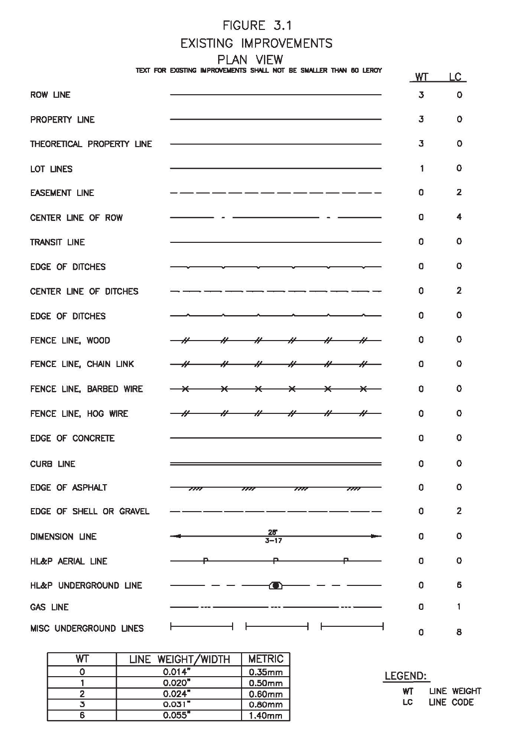
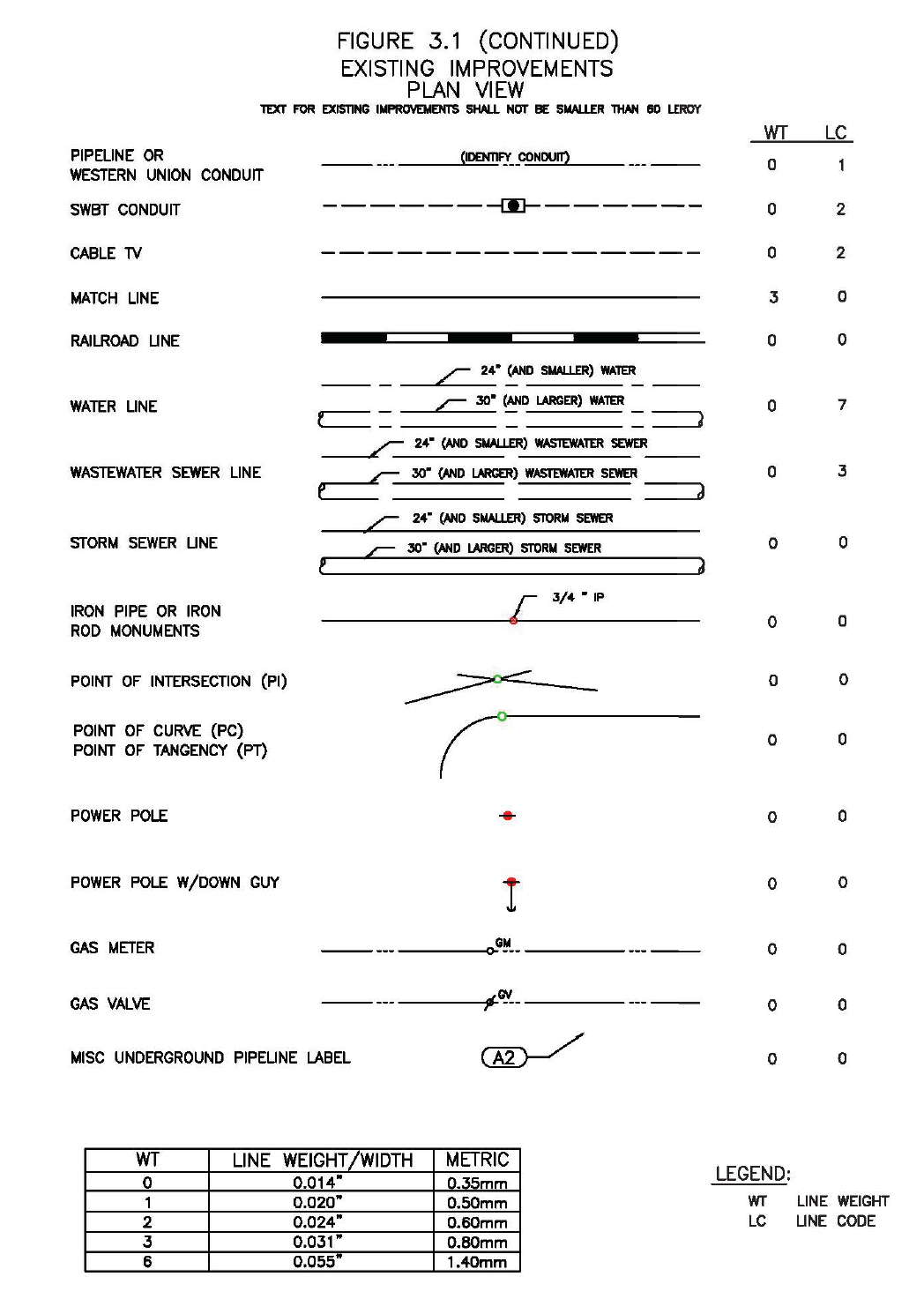
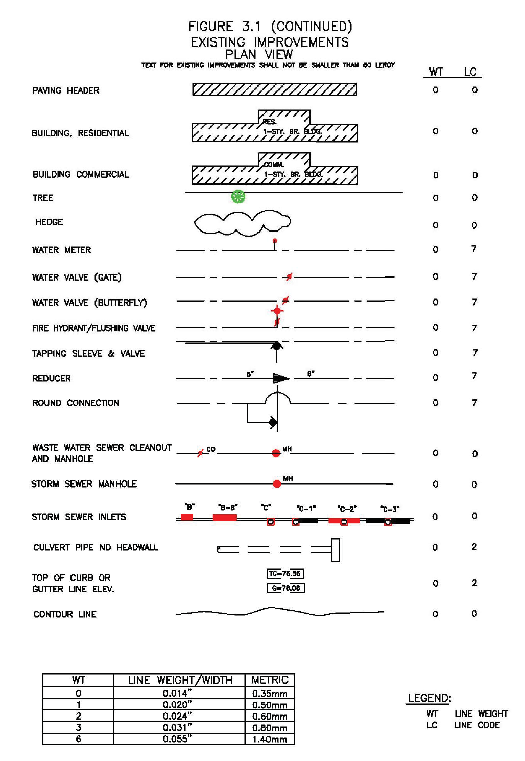
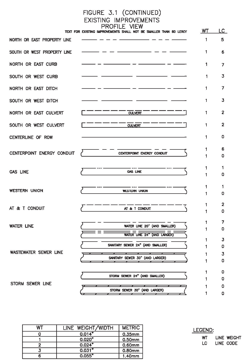
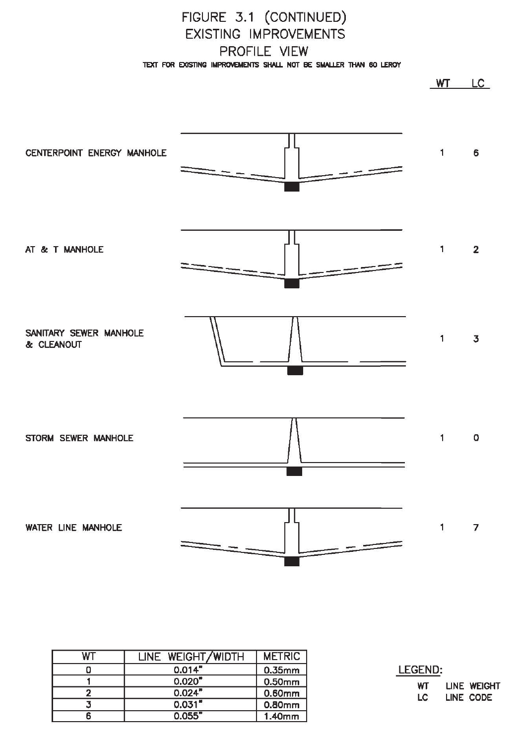
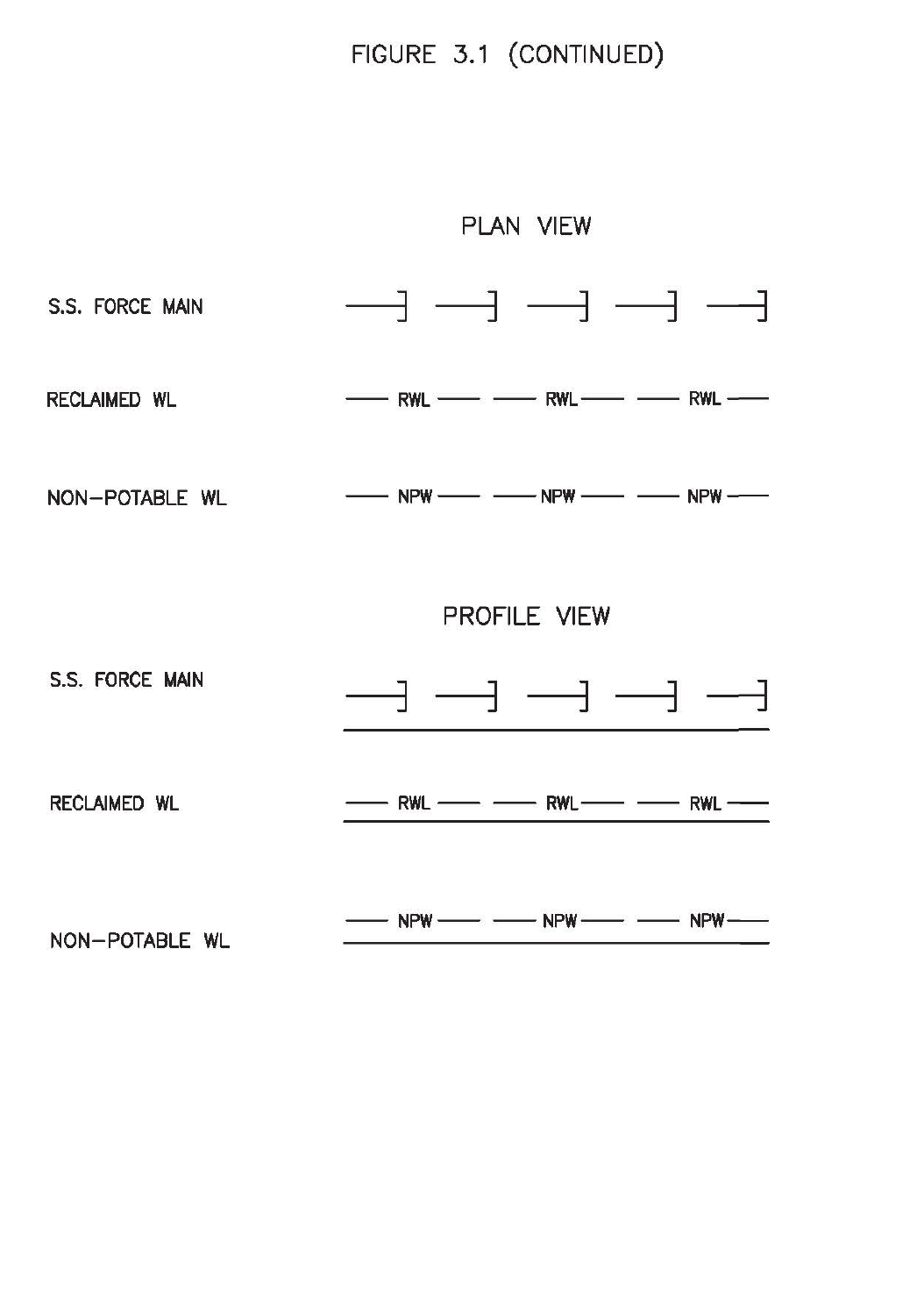
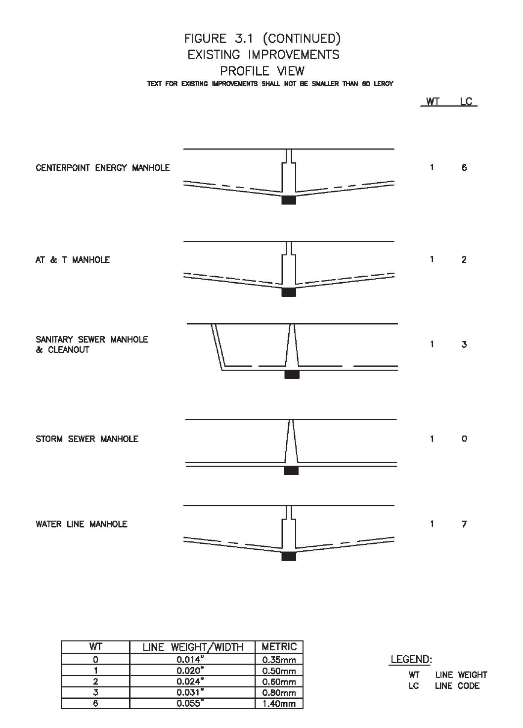
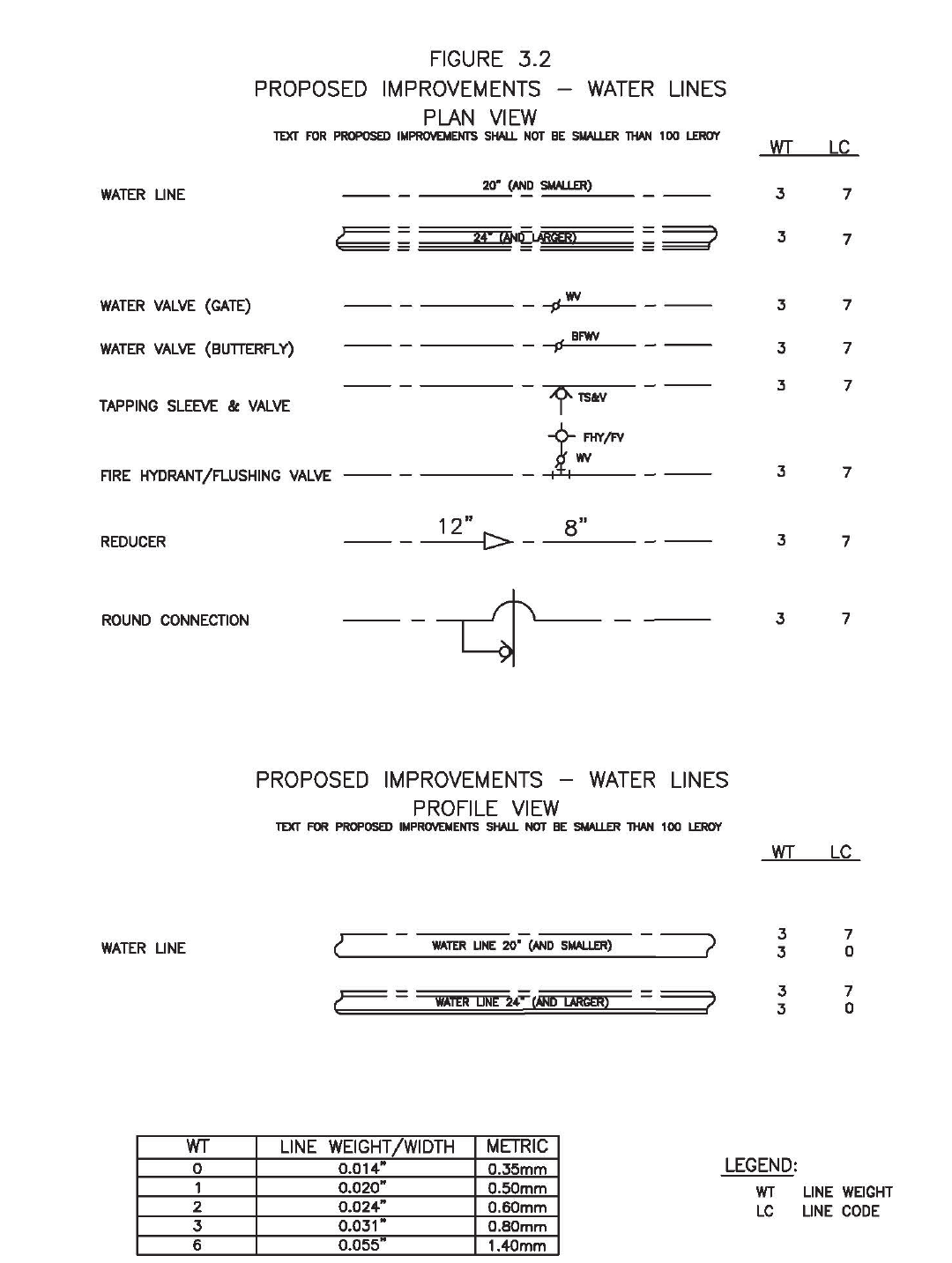
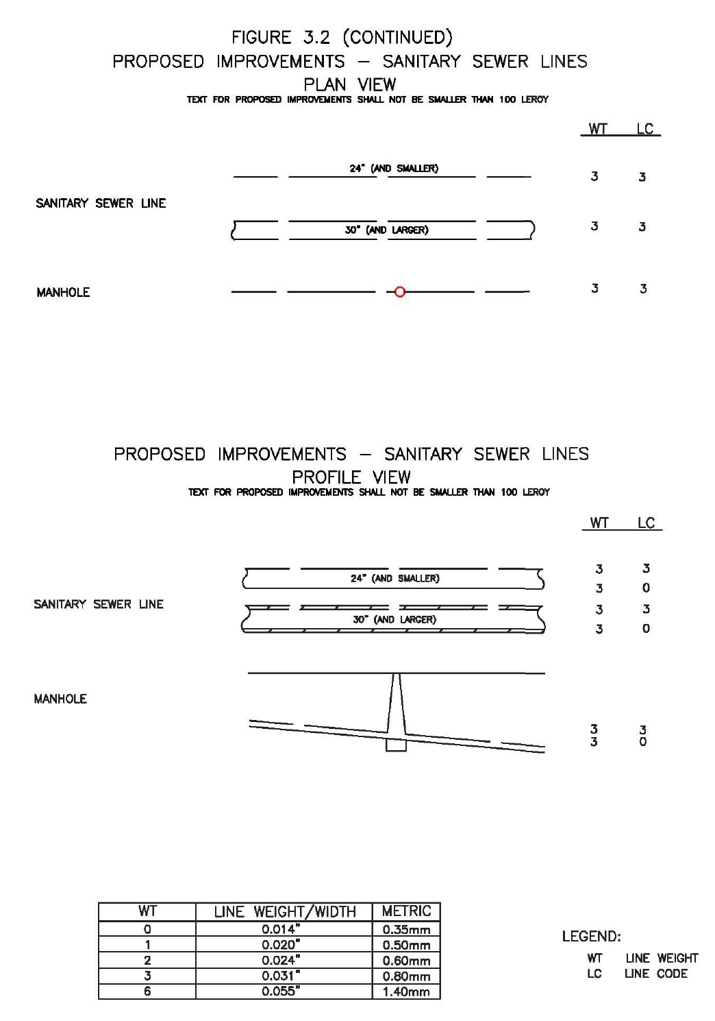
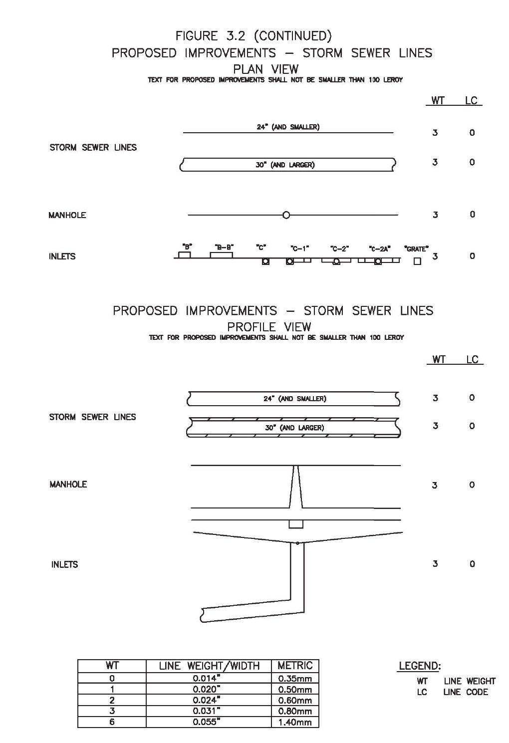
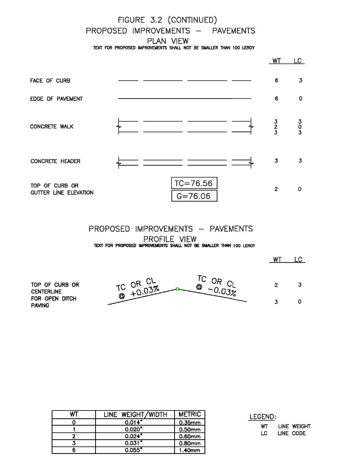
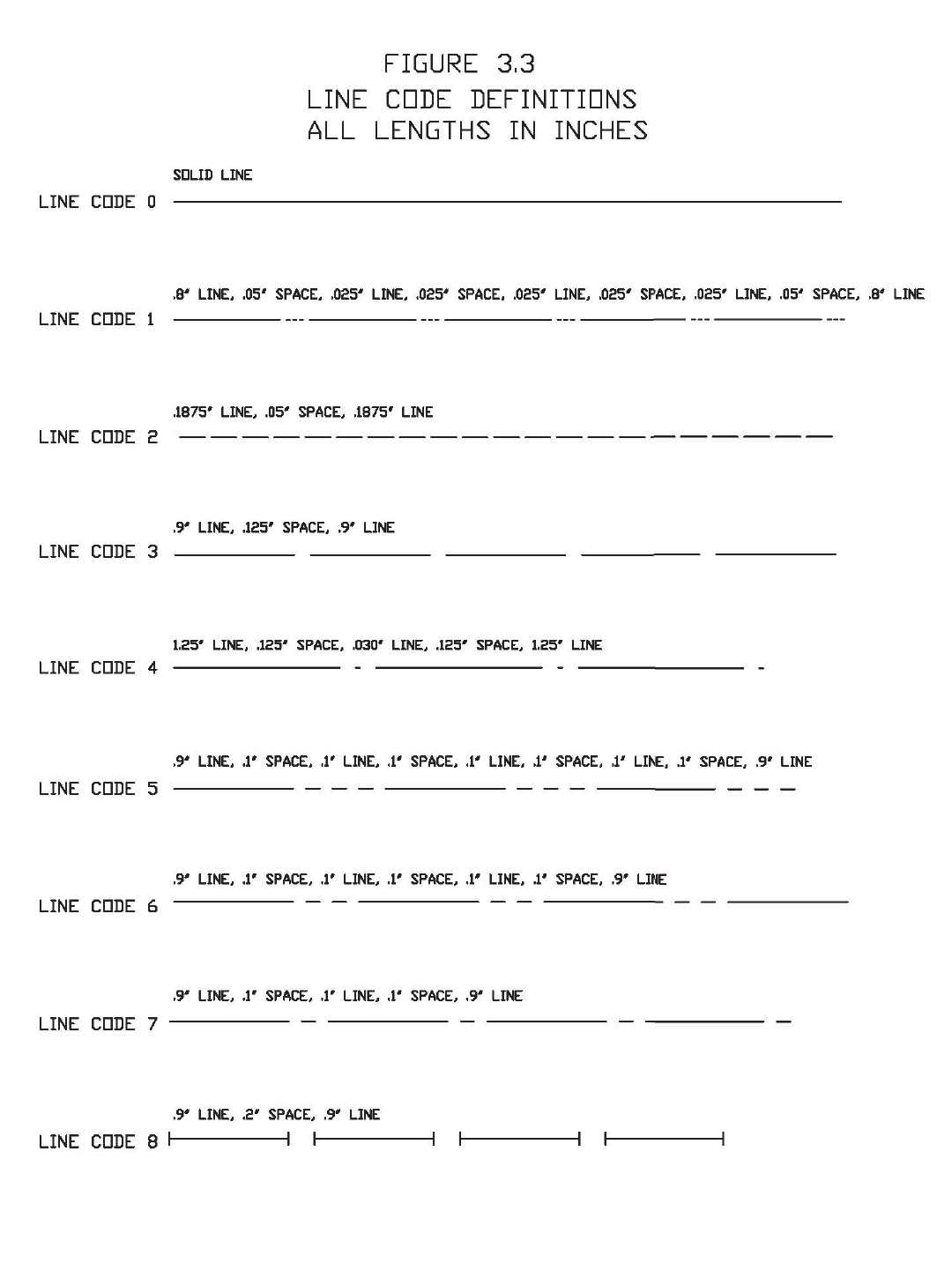

Appendix D
CONSTRUCTION NOTES TO BE
ON ALL PROJECTS
NO
DESCRIPTION OF ITEM
1 Water lines, wastewater collection systems, and storm drainage systems shall be
designed and constructed in accordance with the CITY OF HOUSTON’S, DEPARTMENT
OF PUBLIC WORKS AND ENGINEERING “DESIGN MANUAL, STANDARD
CONSTRUCTION SPECIFICATIONS, AND DETAILS FOR WASTEWATER COLLECTION
SYSTEMS, WATER LINES, STORM DRAINAGE AND STREET PAVING”.
2 All storm sewer will be reinforced concrete (C76 Class III) and shall be installed,
bedded and backfilled in accordance with the City of Houston’s Drawings 02317-02,
02317-03, 02317-05, 02317-06 and 02317-07 as applicable.
3 All storm sewers constructed in side lot easements shall be R.C.P., minimum twenty
(20) foot wide easements shall be provided.
4 An alternative to cement stabilized sand may be used as backfill for pipes fifty-four
(54) inch and larger, from 1-foot above the top of the pipe to the bottom of the
subgrade. Contractor may backfill with suitable material, provided the backfill
material is placed in eight (8) inch lifts and mechanically compacted to ninety-five
(95)% standard proctor density. Tests shall be taken at one hundred (100) foot
intervals on each lift. Bedding and backfill to one (1) foot above the top of the pipe
shall be cement-stabilized sand.
5 All proposed pipe stub-outs from manholes or inlets are to be plugged with eight (8)
inch brick walls unless otherwise noted.
6 The contractor(s) shall notify Harris County Engineering Department – Permit Office
twenty-four (24) hours in advance of commencing utility and/or paving construction
at (713) 274-3823 and written notification forty-eight (48) hours in advance of
commencing construction at 10555 Northwest Freeway, Suite 144, Houston, TX 77092.
7 Paving shall be in accordance with the “Regulations of Harris County, Texas for the
Approval and Acceptance of Infrastructure” and/or amendments of the same.
8 Guidelines set forth in the latest edition of the “Texas Manual on Uniform Traffic
Control Devices, TMUCD with Revisions” shall be observed.
9 OWNER OR OWNER’S AGENT to obtain all permits required by the “Regulations of
Harris County, Texas for Floodplain Management” prior to starting construction.
10 OWNER OR OWNER’S AGENT to obtain all notifications required by Harris County,
Texas prior to starting construction of utilities and/or culverts within Harris County
and Harris County Flood Control District Rights-of-Way.
PLEASE ADD ALL NOTES CIRCLED IN RED TO THE CONSTRUCTION PLANS.

Appendix E
CONSTRUCTION NOTES INVOLVING UTILITIES AND PAVING WORK
LOCATED WITHIN A PUBLIC RIGHT-OF-WAY
NO
DESCRIPTION OF ITEM
1
NOTE: “Notifications Issued by Harris County Engineering
Department – Permits Office – is required for proposed work within
Harris County Right-of-Way. The project must be approved prior to
obtaining the required Notification. Be advised that a Notification
must be obtained separately from site development permit package.
For additional information, please visit
http://www.eng.hctx.net/permits/Public-Review-Code/Public-Plan-
Review/Notification-of-Construction-in-the-ROW or contact Public
Review Inspections Department @ (713-274-3931)”

Appendix F
CONSTRUCTION NOTES FOR
ESPLANADE OPENINGS AND TURN LANES
NO
DESCRIPTION OF ITEM
1 Esplanade noses at the crossover are to be bullet type, painted reflectorized yellow,
in accordance with the Harris County Pavement Marking Detail and to be six inches
(6”) thick with surface colored black for concrete pavement and uncolored for asphalt
pavement, a minimum of six feet (6’) deep measured from the end of the median nose
and the curbs are at least four feet (4’) in width face to face.
2 The relocation of existing trees, landscaping, sprinkler systems, water meters, fire
hydrants, manholes, and pipelines (if applicable) are to be re-installed as
recommended by the Harris County Engineering Department – Permit Office and/or
the Harris County Precinct (If located in Precinct 3, add note: Contractor(s) to
contact Precinct 3 Parks Administration Office @ (281-531-1592) two (2) weeks
prior to construction for tree(s) and landscaping relocation.
3 Existing reinforced concrete pavement is to be machine saw-cut 1-1/2 inches deep to
expose a minimum of twenty-four (24) inches of reinforcing bars and place new
reinforcing bars to match existing steel size and spacing and tie new reinforcing bars
to existing reinforcing bars with eighteen (18) inch laps. Full depth saw-cut may be
used as an alternative.
4 Reinforcing concrete pavement is to be a minimum eight (8) inches with a minimum
of 5.0 sack cement per cubic yard, [4500 psi in twenty-eight (28) days]. Note: Depth
of concrete to meet current requirements of depth of existing pavement whenever it
is greater.
5 Asphalt turn lane to be minimum (2) inches H.M.A.C. with (10) inch base. Road
widening’s done on asphalt roadways for turn lanes must be overlaid full width of the
roadway from beginning to ending transition.
6 Subgrade shall be a minimum of six (6) inches for asphalt and eight (8) inches for
concrete, of a material as specified by the engineer and approved by Harris County,
and compacted to ninety-five (95) percent standard proctor density (+/-) two (2)
percent moisture. Cement stabilized sand, as prescribed by Harris County specs, may
be used as an alternative.
7 Slope on proposed concrete left turn slots is to be a minimum of 1/8 inch per foot with
crown at center of esplanade.
8 All sewers under or within one (1) foot of proposed or future pavement shall be
backfilled with 1-1/2 sack cement stabilized sand to within one (1) foot of subgrade.
9 The contractor shall notify the Harris County Engineering Department – Permit Office
twenty-four (24) hours in advance of commencing construction at (713) 274-3931 and
written notification forty-eight (48) hours in advance of commencing construction for
commercial and residential development.

Appendix F
CONSTRUCTION NOTES FOR
ESPLANADE OPENINGS AND TURN LANES
NO
DESCRIPTION OF ITEM
10 All pavement work will require an accredited lab certification for subgrade, concrete
compressive strength, in place core. Asphalt work will require a sieve test, subgrade
and base compaction results.
11 Paving shall be in accordance with the “Regulations of Harris County, Texas for the
Approval and Acceptance of Infrastructure” relating to the approval and acceptance
of improvements in subdivisions or re-subdivisions and/or amendments of the same.
12 Guidelines set for in the “Manual on Uniform Traffic Control Devices” shall be
observed.
13 Include Harris County Drawing SD-1 as part of the construction plans.
14 Include Harris County Pavement Marking Detail as a part of the construction plans.
15 NOTE: “Notification(s) issued by Harris County Engineering Department - Permit
Office required prior to construction of utilities or turn lanes within Harris County
rights-of-way”. Contact Harris County Permit Office at (713) 274-3931.
16 OWNER OR OWNER’S AGENT to obtain all permits and notification(s) required by
Harris County, Texas prior to starting construction of utilities and/or culverts within
Harris County road rights-of-way.
PLEASE ADD ALL NOTES CIRCLED IN RED TO THE CONSTRUCTION PLANS.

Appendix G
CONSTRUCTION NOTES FOR ALL
PROJECTS LOCATED IN THE 1% (100-YEAR) FLOODPLAIN AND .2%
(500-YEAR) FLOODPLAIN
NO
DESCRIPTION OF ITEM
1 All proposed construction shall be in accordance with the “Regulations of Harris
County, Texas for Floodplain Management”.
2 OWNER OR OWNER’S AGENT to obtain all permits required by Harris County,
Texas prior to starting development within Harris County and Harris County road
rights-of-way.
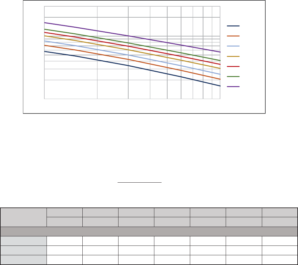
Appendix H
Intensity Duration Curves
Region 3*
*Regions can be found in the Harris County Flood Control District Policy, Criteria, and Procedure Manual Reference Section
6.02.1.B. for design requirements.
Intensity,
Coefficient
50 % AEP 20 % AEP 10 % AEP 4 % AEP 2 % AEP 1 % AEP 0.2 % AEP
2-Year 5-Year 10-Year 25-Year 50-Year 100-Year 500-Year
Region 3
e 0.7244 0.6900 0.6623 0.6294 0.6096 0.5797 0.5196
b (in.) 48.35 52.32 54.68 57.79 61.00 60.66 62.17
d (min.) 9.07 7.88 6.96 5.89 5.46 4.44 2.95
AEP - annual exceedance probability
e
)( TCd
b
i
1.0
10.0
10 100
Rainfall Intensity (in/hr)
Time of Concentration, TC (min)
2 Year
5 Year
10 Year
25 Year
50 Year
100 Year
500 Year
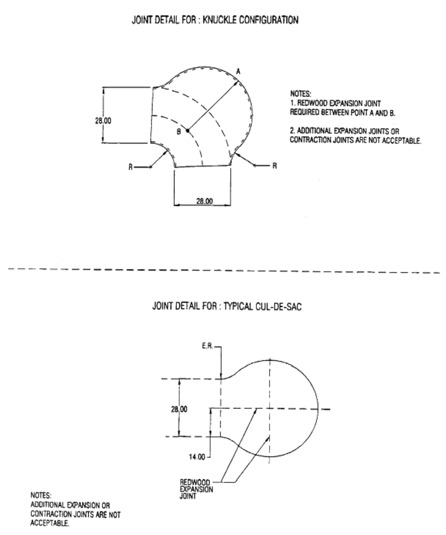
Appendix I
Button Detail For: Knuckle Configuration
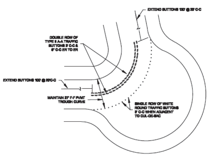
Appendix J
Benchmark Requirements
Standards
New benchmarks are required to use the same criteria established during the Tropical
Storm Allison Recovery Project. The mark will be established using NAVD 1988, 2001
Adjustment Elevation and the GEOID 99 ellipsoid model to match the current Flood
Insurance Rate Map effective June 18, 2007.
Use as much as possible dual frequency, full-wavelength Global Positioning System (GPS)
receivers. The National Geodetic Survey (NGS) 2-centimeter standard, as published in
NOAA Technical Memorandum NOS NGS-58 dated November 1997 is the vertical
surveying standard. The horizontal standard is the NGS Second Order Class I standard as
published in the Federal Geodetic Control Committee (FGCC) document entitled
“Geometric Geodetic Accuracy Standards and Specifications for Using GPS Relative
Positioning Techniques” dated August 1, 1989. In areas where it is impossible to use GPS
due to conditions such as obstructed sky visibility, precise differential leveling is required
to connect such obstructed benchmarks to the rest of the network. Differential leveling
will be used to meet the maximum loop misclosure specifications for the NGS Second
Order Class II vertical stand for leveling, as published in the FGCC document entitled
“Standards and Specifications for Geodetic Control Networks” dated September 1984.
The control will meet the NGS Classification system for Range VI positions. Range VI
indicates that these positions meet the 0.02 meter 0 0.05 meter Accuracy Standard for
Horizontal Position, Ellipsoidal Height, and Orthometric Height (elevation) and the 95%
confidence level.
Survey Control
The controls to be used are the Continuously Operating Reference Stations (CORS)
monitored by NGS. The CORS stations located at extensometer sites are constructed so
as to be unaffected by the subsidence of the ground around them. They are considered
by HGCSD and others to be the most stable control monuments in Harris County. The
three CORS sites are as follows:
PID AJ6426 ADDICKS 1795 CORS ARP (ADKS)
PID AJ6430 NORTHEAST 2250 CORS ARP (NETP)
PID AF9521 LAKE HOUSTON CORS ARP (LKHU)
PID = Permanent Identifier
ARP = Antenna Reference Point (physical bottom of the antenna)
The 1997.00 Epoch Date will be referenced to coincide with the existing network.

Benchmark Construction
A brass disk, provided by Harris County Flood Control District, shall be set in a drilled
hole in the concrete on a permanent structure and fastened with epoxy cement or
established as a permanent monument. A Reference Mark Number will be assigned to
your new monument. Stamp the new disk with the newly assigned Reference Mark
Number.
Benchmark Acceptance
Reference Mark submittal forms can be obtained from the Harris County Permits Office
or downloaded from the website, http://www.eng.hctx.net/permits. A Texas State
Registered Professional Land Surveyor is required to set, level and submit for
acceptance new benchmarks. Submit two (2) paper copies and the digital file of the
fully completed forms to the Harris County Permits Office. After acceptance, the
benchmark information will be uploaded to the Harris County benchmark website for
public use.
APPENDIX K
UNIFORM STANDARDS FOR PUBLIC STREET NAMING
This appendix is written to provide clarification to the street naming standards in
Harris County. Uniformity in street name selection is essential to public safety as it
reduces confusion to the general traveling public, and most importantly reduces
confusion to the emergency service providers.
PRINCIPLES:
Public street naming shall follow these principles:
1. Named in a manner that reduces confusion to the traveler, utility providers,
addressing authority, and most importantly the emergency service provider.
2. When located within, or partially within a Municipality or its Extraterritorial
Jurisdiction (ETJ), street name selection shall follow the guidelines for naming
streets enacted by that Municipality.
3. “One Street – One Name Principle” - Maintains the same name for the entire
limits of the street.
a. When presented the opportunity through a street limit extension or other
improvements, the County Engineer will, when able, require street name
uniformity for the entire limits of the street where it does not currently
exist.
b. Regardless of planned improvements, if at any point a safety concern is
discovered due to non-uniformity, the County Engineer may recommend
changing the street name to facilitate uniformity and safety.
4. All steps necessary to change a street name will be executed by the applicant.
GUIDELINES:
In general, to meet the three principles outlined above, the following are guidelines for
naming streets within Harris County:
1. A new street that is an extension of an existing street or master planned street
shall have the same name as the existing street.
2. A non-public street that is a direct extension of a public street or a cul-de-sac
shall not have the same name as the public street.
3. A directional prefix or suffix may be used to clarify the general location of a
street, provided that the use of the directional prefix or suffix is consistent with
the established naming convention within the area in which the street exists.
4. Street name suffixes shall be limited to the following uses:
a. “Circle”, “Court” and “Loop” shall be used only to designate streets that
terminate at a cul-de-sac or are configured as a geometrically looped street.
b. “Boulevard”, “Crossing”, “Crossroad, “Expressway”, “Motorway”,
“Parkway”, “Speedway” or “Throughway” shall be used only to designate
major thoroughfares, major collector streets, collector streets or other
streets designed to handle traffic volumes in excess of normal neighborhood
traffic generation or that are boulevard sections (i.e. median divided) with
at least two lanes of traffic in each direction.
c. “Bypass”, “Expressway”, “Freeway” and “Highway” shall be used only to
designate highway or freeways subject to jurisdiction of the state
department of transportation.
d. “Avenue”, “Drive”, “Road”, and “Street” shall be used only to designate
major thoroughfares, major collector streets, collector streets, or local
streets.
e. “Bridge”, “Fork”, “Lane”, “Oval”, “Passage”, “Path”, “Place”, “Trail” and
“Way” shall be used only to designate collector streets or local streets.
f. “Tunnel” shall be used only to designate streets that provide underground
or underwater passage.
g. A street name suffix shall not be used as part of the street name.
h. The abbreviation of a street name suffix shall be consistent with the United
States Postal Service postal addressing standards.
5. A street name shall not include any typographic characters or symbols.
6. An alphabetical or numerical street name shall not be used to name a new street
unless the new street is a direct extension of an existing street with an
alphabetical or numerical name that is not duplicative of an existing street name.
7. When a street changes horizontal direction by approximately 90 degrees, the
street name shall change.
For purposes of the section, the terms cul-de-sac, collector street, and local street shall
have the meanings assigned to those terms by the Federal Highway Administration
(FHWA) and/or American Association of State Highway and Transportation Officials
(AASHTO) “A Policy on Geometric Design of Highway and Streets”.
EXEMPTIONS
For streets located in an Extraterritorial Jurisdiction of a municipality, the County
Engineer will review requests for exceptions only after written approval for the
exception from the Municipality is obtained by the applicant. In locations without
Extraterritorial Jurisdiction, requests for exceptions will follow the procedures outlined
within the Harris County Infrastructure Regulations.
